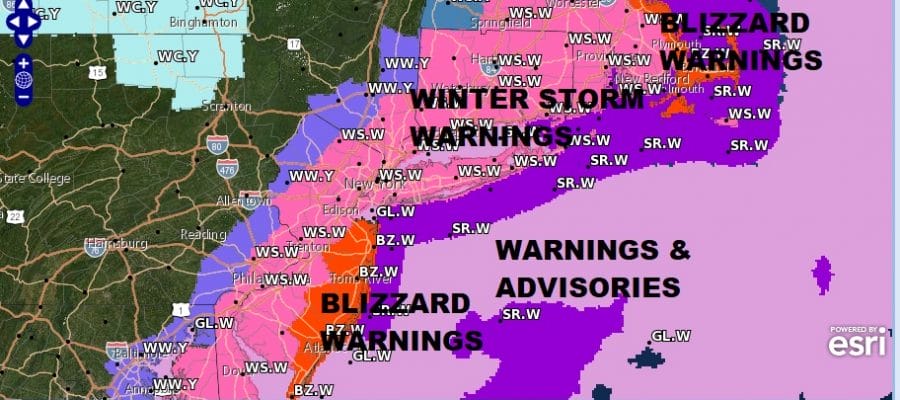
Blizzard Warnings Coastal New Jersey, SE New England
Winter Storm Warnings Delaware to New England

Weather in 5/Joe & Joe Weather Show Latest Podcast
Blizzard Warnings Coastal New Jersey, SE New England
Winter Storm Warnings Delaware to New England

A major ocean storm is developing off the Southeast coast and after days of consternation, we are finally here at Friday and it will be a high impact event. Bliizzard Warnings are in effect for the coastal counties of New Jersey and Southeastern New England. Winter Storm Warnings extend up and down the coast from Delaware to almost all of New Jersey, the lower Hudson Valley, Southern and the rest of Southeastern New England. On the northwest edge of the warning area we have winter weather advisories in effect for the the counties north and west of Philadelphia and in Northwest New Jersey.
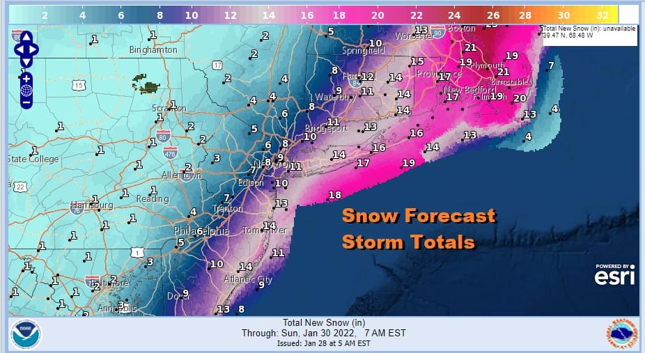
One foot snow accumulations ore more are forecast from coastal southern New Jersey to Long Island and from Southeast Connecticut to Southeastern Massachusetts where some 20 inch plus amounts are forecast. My FINAL CALL snow forecast map is up and was issued at 11pm Thursday night. It is a little higher then the NWS weather service but not by much.

There will be some lead snow that will break out today thanks to an approaching arctic front. The front falls apart but the atmosphere is ripe with developing energy and increasing moisture we already have lots of clouds and on the radar snow has developed.. Most of it is on the light side but there may be enough to leave a coating to an inch or so today. Temperatures will top in the low to mid 30s.
SATELLITE

WEATHER RADAR

The really snow begins tonight as snow rapidly develops from southwest to northeast. Low pressure strengthens rapidly and heads northeast and passes to the east of New Jersey and south of Long Island early Saturday afternoon. The heaviest snow will fall from late tonight into early Saturday afternoon from New Jersey to Long Island and Southwestern New England and then after that will slowly being to taper off.

Further east into Southeastern New England the snow will last until Saturday night before tapering off and ending. There 15 inches or more are forecast. Also through this we will see strong northerly winds develop of 20 to 35 mph with gusts to 50 to 60 mph or more possible along the coast and lower gusts but still some gusts to 40 mph or ore inland. We will likely see additional blizzard warnings go up in parts of Southern New England and Long Island at some point. Inland accumulations will be less and note that there is a sharp cut off of the snow somewhere near the Pennsylvania New Jersey state line. Temperatures will be falling into and through the 20s and by midday Saturday most of the area will see temperatures in the upper teens and lower 20s so wind chills will be down near or even below zero at times. Weather conditions improve Sunday which will be a breezy and cold day as the storm moves away with some sunshine developing and highs just in the 20s in most places.
BE SURE TO DOWNLOAD THE FREE METEOROLOGIST JOE CIOFFI WEATHER APP &
ANGRY BEN’S FREE WEATHER APP “THE ANGRY WEATHERMAN!
MANY THANKS TO TROPICAL TIDBITS & F5 WEATHER FOR THE USE OF MAPS
Please note that with regards to any severe weather, tropical storms, or hurricanes, should a storm be threatening, please consult your local National Weather Service office or your local government officials about what action you should be taking to protect life and property.


