
Blizzard Warning Winter Storm Warning
Blizzard Warning Winter Storm Warning
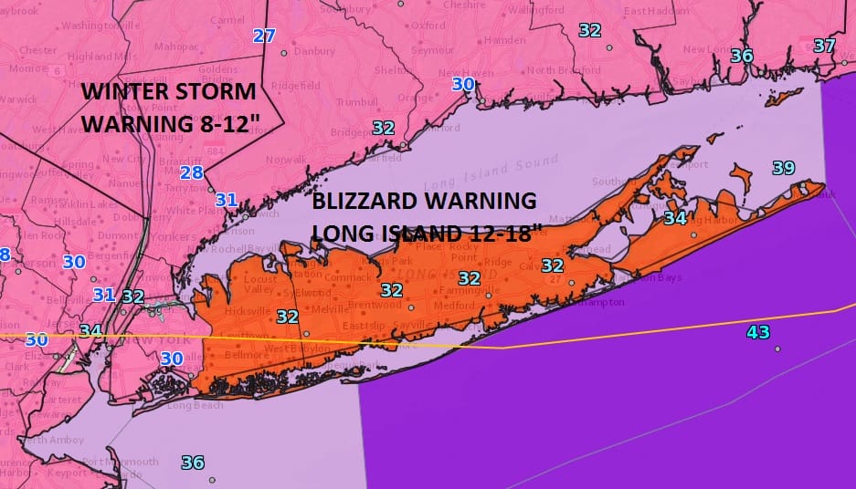
Everything regarding the winter storm or blizzard for Long Island is going along as advertised by weather models the last 2 days. Once they zeroed in on the development and track (with a few wobbles along the way) we are seeing heavy snow at this point. The satellite loop shows the storm center moving off the Maryland coast this morning and it will be moving off to the northeast at a pretty good clip. This prevents it from becoming a monstrous blizzard of 2 to 3 foot snows but there will be every bit of 12 to 18 inches across some areas east of New York City and along the coast including Long Island and even some parts of South Coastal Connecticut.
SATELLITE LOOP

REGIONAL RADAR

LOCAL RADAR NEW YORK CITY

LOCAL RADAR PHILADELPHIA


All the radars are loaded at the moment with heavy snow. The rain snow line will continue to sweep southeastward and change the rain to snow in Southern New Jersey over the next few hours. Snow amounts across Northern New Jersey north of Route 195 will be on the order of 6 to 10 inches..some parts of Northern Monmmouth County to Northeastern New Jersey will be in a zone of 8 to 12 as will the Hudson Valley and most of Western Connecticut north of route 84. South of Route 84 it should be every bit of a foot fo snow before it all tapers off this afternoon. Snow will end in New Jersey between noon and 2pm..in Long Island and across the Hudson Valley eastward..some time from 1pm in the west to 4pm in Eastern areas of Long Island. Temperatures are falling this morning through the 20s. Winds will be gusting to gale force.
The maps below are the National Weather Service forecast snow maps with the most likely snowfall prediction.


Weather conditions improve tonight with clearing skies but it will be windy and bitter cold with lows in the single digits to the low and mid teens. Sunshine forecast for Friday but temperatures won’t be out of the 20s.
SNOW REMOVAL COMPANIES FOR YOUR WINTER NEEDS
LONG ISLAND ROCKLAND COUNTY Connecticut

![]()

ROCKLAND COUNTY TRI STATE SNOW REMOVAL JOHNSTOWN PA


FiOS1 News Weather Forecast For Long Island
FiOS1 News Weather Forecast For New Jersey
FiOS1 News Weather Forecast For Hudson Valley
NATIONAL WEATHER SERVICE SNOW FORECASTS
LATEST JOESTRADAMUS ON THE LONG RANGE
Weather App

Don’t be without Meteorologist Joe Cioffi’s weather app. It is really a meteorologist app because you get my forecasts and my analysis and not some automated computer generated forecast based on the GFS model. This is why your app forecast changes every 6 hours. It is model driven with no human input at all. It gives you an icon, a temperature and no insight whatsoever.
It is a complete weather app to suit your forecast needs. All the weather information you need is right on your phone. Android or I-phone, use it to keep track of all the latest weather information and forecasts. This weather app is also free of advertising so you don’t have to worry about security issues with your device. An accurate forecast and no worries that your device is being compromised.
Use it in conjunction with my website and my facebook and twitter and you have complete weather coverage of all the latest weather and the long range outlook. The website has been redone and upgraded. Its easy to use and everything is archived so you can see how well Joe does or doesn’t do when it comes to forecasts and outlooks.
Just click on the google play button or the apple store button on the sidebar for my app which is on My Weather Concierge. Download the app for free. Subscribe to my forecasts on an ad free environment for just 99 cents a month.
Get my forecasts in the palm of your hand for less than the cost of a cup of Joe!


