Bitter Cold Weekend Before Heading Back to 60!
Bitter Cold Weekend Before Heading Back to 60!
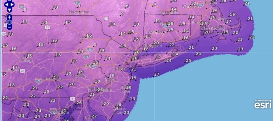
We are seeing the coldest air in weeks moving in for the weekend and it is beginning tonight as temperatures head down to the teens and low 20s and wind chills will knock off another 10 degees from this. It is the cold plus the fact that it has been so warm for the last 3 weeks that we just aren’t used to it.

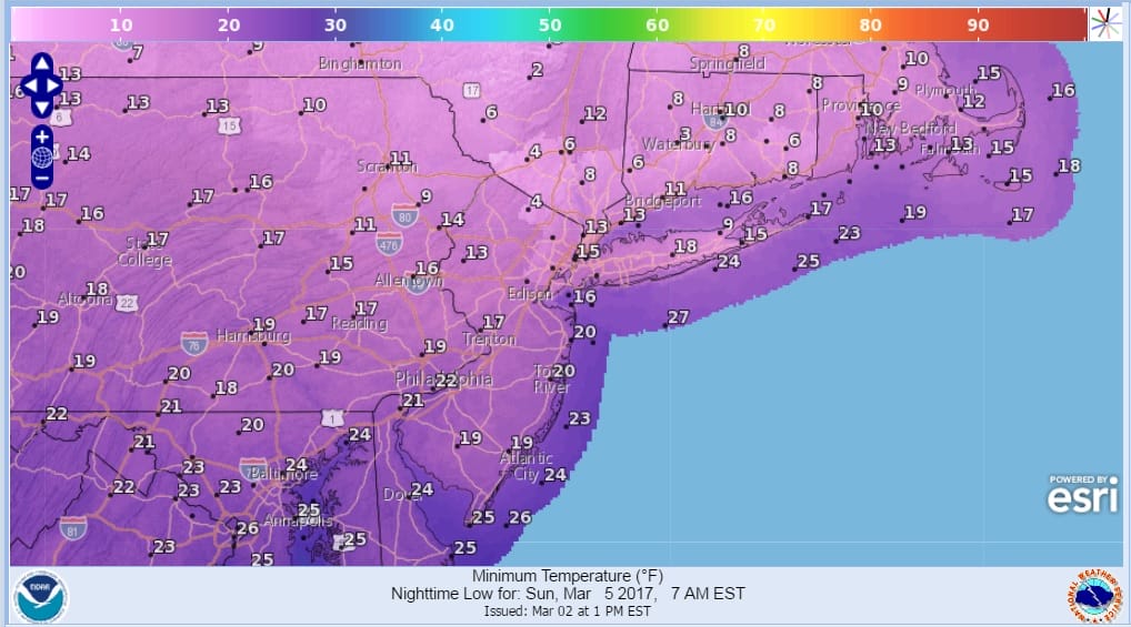
Saturday’s highs will barely make it back to the freezing mark and some places will have a hard time getting out of the 20s. At least we will have ineffective sunshine and lots of it. Then down we go again Saturday night with lows in the teens and single digits by Sunday morning.
The satellite and radar both show an upper air disturbance with clouds and some snow showers moving through this evening but they should be done shortly. Then skies should clear out fairly quickly.
SATELLITE LOOP

REGIONAL RADAR

LOCAL RADAR NEW YORK CITY

LOCAL RADAR PHILADELPHIA


Sunday we will see plenty of sunshine with highs in the 30s in most places. Then the warm up begins with some sunshine and arriving clouds on Monday with highs back into the 40s. Then another cold front approaches late Tuesday so it will be back into the 50s to near 60 with the risk of showers and possible thunderstorms.
Longer range late next week and beyond will continue to hinge on 2 factors. Blocking in the North Atlantic and how strong it is and whether the pattern of deep upper air troughs in the west continues or does it break down? The European model is showing the second choice today which is something we will explore over the weekend if that trend continues.
 GET JOE A CIGAR IF YOU LIKE

SNOW REMOVAL COMPANIES FOR YOUR WINTER NEEDS
LONG ISLAND ROCKLAND COUNTY Connecticut

![]()

ROCKLAND COUNTY TRI STATE SNOW REMOVAL JOHNSTOWN PA


FiOS1 News Weather Forecast For Long Island
FiOS1 News Weather Forecast For New Jersey
FiOS1 News Weather Forecast For Hudson Valley
NATIONAL WEATHER SERVICE SNOW FORECASTS
LATEST JOESTRADAMUS ON THE LONG RANGE
Weather App

Don’t be without Meteorologist Joe Cioffi’s weather app. It is really a meteorologist app because you get my forecasts and my analysis and not some automated computer generated forecast based on the GFS model. This is why your app forecast changes every 6 hours. It is model driven with no human input at all. It gives you an icon, a temperature and no insight whatsoever.
It is a complete weather app to suit your forecast needs. All the weather information you need is right on your phone. Android or I-phone, use it to keep track of all the latest weather information and forecasts. This weather app is also free of advertising so you don’t have to worry about security issues with your device. An accurate forecast and no worries that your device is being compromised.
Use it in conjunction with my website and my facebook and twitter and you have complete weather coverage of all the latest weather and the long range outlook. The website has been redone and upgraded. Its easy to use and everything is archived so you can see how well Joe does or doesn’t do when it comes to forecasts and outlooks.
Just click on the google play button or the apple store button on the sidebar for my app which is on My Weather Concierge. Download the app for free. Subscribe to my forecasts on an ad free environment for just 99 cents a month.
Get my forecasts in the palm of your hand for less than the cost of a cup of Joe!


