Beautiful Day Warmer Humid Weather Ahead
Beautiful Day Warmer Humid Weather Ahead
We are enjoying a beautiful afternoon of sunshine as the satellite loop shows us almost free and clear of clouds. Offshore clouds from the old weekend storm and cold front lie well to the east and Tropical Storm Emily is over Florida as the center has come inland south of Tampa earlier this afternoon. Heavy rains continue in the Southern half of Florida but Emily is no threat to our weather as it will probably track northeastward once it emerges in the Atlantic and remain well offshore. Meanwhile the dry air over us extends westward to the Mississippi River and this insures us a night of clear skies ahead. Temperatures this afternoon are in the warm 80s and lows tonight will be in the 60s to around 70.
SATELLITE LOOP

REGIONAL RADAR

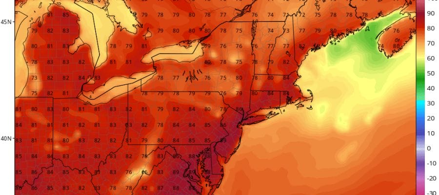
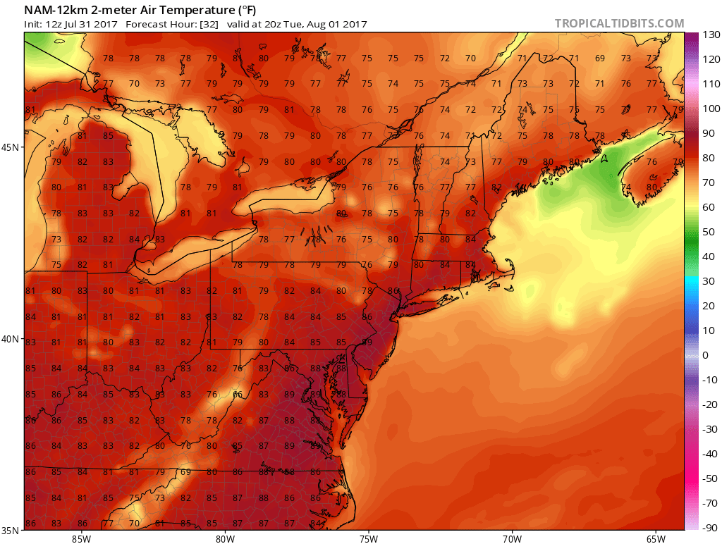
Radars today across the Northeast and Middle Atlantic are getting a break from the usual array of showers and thunderstorms that like to pop up in the afternoon and evening. A few might start to appear on Tuesday in areas well north and west of the coast but for the most part no issues with thunderstorms until later Wednesday. Tuesday will be a little more humid and a little warmer with highs in the 80s to near 90.
BEAUTIFUL DAY TUESDAY’S FORECAST HIGHS
There may be a chance for scattered thunderstorms late in the day on Wednesday as a week upper air disturbance might be strong enough to trigger off a few here and there. The same holds for Thursday with highs both days in the 80s to near 90. Friday and Saturday we have a better chance for thunderstorms with the next cold front approaches and moves through. Sunday right now looks dry and nice with sunshine.
 GET JOE A CIGAR IF YOU LIKE

LANDSCAPE COMPANIES FOR YOUR NEEDS
LONG ISLAND ROCKLAND COUNTY Connecticut

![]()

ROCKLAND COUNTY TRI STATE SNOW REMOVAL JOHNSTOWN PA


FiOS1 News Weather Forecast For Long Island
FiOS1 News Weather Forecast For New Jersey
FiOS1 News Weather Forecast For Hudson Valley
NATIONAL WEATHER SERVICE SNOW FORECASTS
LATEST JOESTRADAMUS ON THE LONG RANGE
Weather App

Don’t be without Meteorologist Joe Cioffi’s weather app. It is really a meteorologist app because you get my forecasts and my analysis and not some automated computer generated forecast based on the GFS model. This is why your app forecast changes every 6 hours. It is model driven with no human input at all. It gives you an icon, a temperature and no insight whatsoever.
It is a complete weather app to suit your forecast needs. All the weather information you need is right on your phone. Android or I-phone, use it to keep track of all the latest weather information and forecasts. This weather app is also free of advertising so you don’t have to worry about security issues with your device. An accurate forecast and no worries that your device is being compromised.
Use it in conjunction with my website and my facebook and twitter and you have complete weather coverage of all the latest weather and the long range outlook. The website has been redone and upgraded. Its easy to use and everything is archived so you can see how well Joe does or doesn’t do when it comes to forecasts and outlooks.
Just click on the google play button or the apple store button on the sidebar for my app which is on My Weather Concierge. Download the app for free. Subscribe to my forecasts on an ad free environment for just 99 cents a month.
Get my forecasts in the palm of your hand for less than the cost of a cup of Joe!


