
Backdoor Cold Front Dropping South

When you check out the latest observations at 10pm you can see the backdoor cold front dropping southward. Winds have turned north or northeast from New York City northward and temperatures are falling now in those areas into the 40s. South of the front temperatures are still holding above 50 with the southwest wind.
Backdoor Cold Front Dropping South 10 pm TEMPERATURES AND WIND

Much of the more important cloud cover is still north of the area but those clouds will also gradually sink southward overnight. A large twist in the clouds is evident across the Upper Mississippi Valley where low pressure is developing. Snow is occurring across much of the upper midwest at the moment and Winter Storm Warnings are posted for those areas.
Backdoor Cold Front Dropping South Satellite Loop

Backdoor Cold Front Dropping South Regional Radar

Radar is showing moisture building across parts of upstate New York where it may be cold enough for snow as high pressure feeds down cold air into those areas tonight. Temperatures here will eventually settle into the 40s but areas south of New York City may hold up for awhile longer. The front is only going to get so far south before stalling out. It will eventually pass back through here as a warm front tomorrow night.
Backdoor Cold Front Dropping South Local Radars


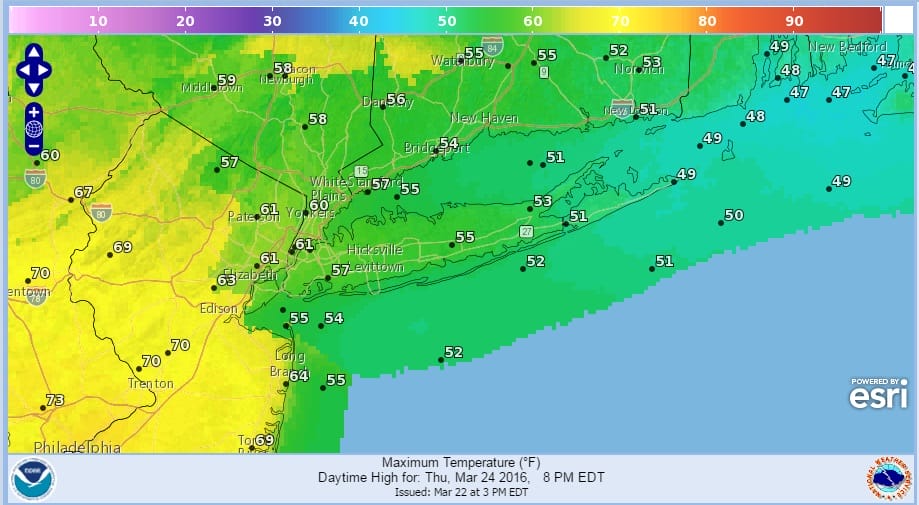
The issue for Thursday will be clouds and wind direction. This will limit sun and temperatures. Look for 50s along the coast and 60s inland. 70 degree readings are possible in Southwest New Jersey and Southeast Pennsylvania. The front lifts northward Thursday night with some showers after midnight. Friday will start with showers and temperatures will reach the 60s before the front passes. Improvement should begin Friday after noon. We will cool down to a nice Easter Weekend.
FiOS1 News Weather Forecast For Long Island
FiOS1 News Weather Forecast For New Jersey
FiOS1 News Weather Forecast For Hudson Valley
NATIONAL WEATHER SERVICE SNOW FORECASTS
LATEST JOESTRADAMUS ON THE LONG RANGE
Weather App

Don’t be without Meteorologist Joe Cioffi’s weather app. It is really a meteorologist app because you get my forecasts and my analysis and not some automated computer generated forecast based on the GFS model. This is why your app forecast changes every 6 hours. It is model driven with no human input at all. It gives you an icon, a temperature and no insight whatsoever.
It is a complete weather app to suit your forecast needs. All the weather information you need is right on your phone. Android or I-phone, use it to keep track of all the latest weather information and forecasts. This weather app is also free of advertising so you don’t have to worry about security issues with your device. An accurate forecast and no worries that your device is being compromised.
Use it in conjunction with my website and my facebook and twitter and you have complete weather coverage of all the latest weather and the long range outlook. The website has been redone and upgraded. Its easy to use and everything is archived so you can see how well Joe does or doesn’t do when it comes to forecasts and outlooks.
Just click on the google play button or the apple store button on the sidebar for my app which is on My Weather Concierge. Download the app for free. Subscribe to my forecasts on an ad free environment for just 99 cents a month.
Get my forecasts in the palm of your hand for less than the cost of a cup of Joe!
![]()
![]()

MENTION JOE CIOFFI AND GET A 5% DISCOUNT


