
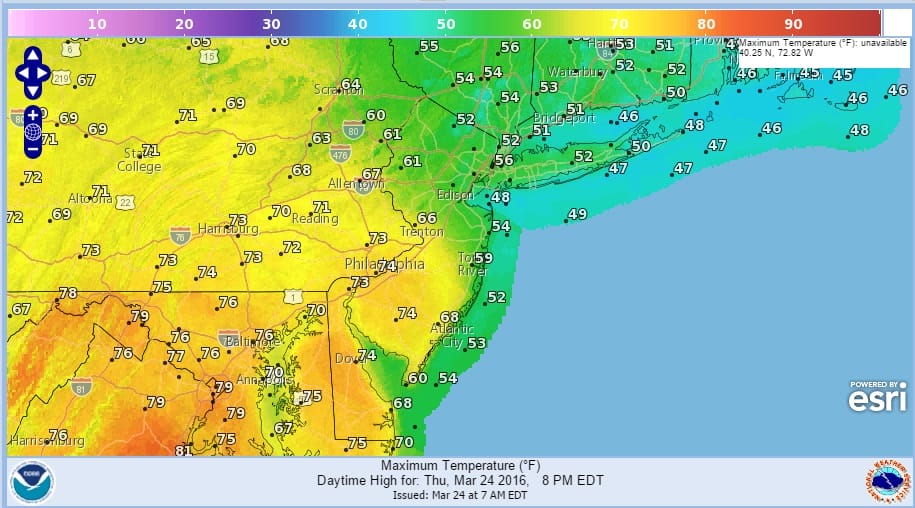
Highs Today Twenty Five Degree Spread

The back door cold front has stalled out pretty much right across the state of New Jersey and this is going to create a large temperature range this afternoon. South of the front highs could reach 70 to 75 while north and east of it some places will barely be into the 50s. There is a huge difference with an east to south wind off the ocean water this time of year and it gets played out on land even if there is a fair amount of sunshine. The front almost runs on a diagonal from Northeast Pennsylvania southeastward to the Central New Jersey coast. Southwest of that line it gets into the 70s! Connecticut and long island do not get out of the 50s, Neither does the Hudson Valley into Northern New Jersey.
Highs Today Twenty Five Degree Spread
It is hard to pick the front out in terms of clouds because aloft at least we are going to see warmer air coming in thanks to a storm moving through the midwest. The weather front with it will produce some severe weather today across the Tennessee Valley and the showers from that front will get here late tonight (after midnight) and should be done by mid day Friday. Weather conditions improve Friday afternoon.
Highs Today Twenty Five Degree Spread Satellite Loop

Highs Today Twenty Five Degree Spread Radar Loops


Temperatures tonight will hold in the 50s and 60s as the back door front backs up northward again. Rainfall from this front should not amount to much. Skies should begin to clear out Friday afternoon with temperatures in the 60s but dropping later in the day. No changes in the forecast for Easter Weekend. There should be some sunshine Saturday and Sunday and highs both days will probably be in the 50s. The next round of rain comes later Monday into Tuesday as low pressure comes out of the midwest and heads our way to the east coast.
There is no change in the longer term outlook. Models are continuing to point to a shot of cold air for next weekend that should last a few days. More on that on my latest Joestradamus post
FiOS1 News Weather Forecast For Long Island
FiOS1 News Weather Forecast For New Jersey
FiOS1 News Weather Forecast For Hudson Valley
NATIONAL WEATHER SERVICE SNOW FORECASTS
LATEST JOESTRADAMUS ON THE LONG RANGE
Weather App

Don’t be without Meteorologist Joe Cioffi’s weather app. It is really a meteorologist app because you get my forecasts and my analysis and not some automated computer generated forecast based on the GFS model. This is why your app forecast changes every 6 hours. It is model driven with no human input at all. It gives you an icon, a temperature and no insight whatsoever.
It is a complete weather app to suit your forecast needs. All the weather information you need is right on your phone. Android or I-phone, use it to keep track of all the latest weather information and forecasts. This weather app is also free of advertising so you don’t have to worry about security issues with your device. An accurate forecast and no worries that your device is being compromised.
Use it in conjunction with my website and my facebook and twitter and you have complete weather coverage of all the latest weather and the long range outlook. The website has been redone and upgraded. Its easy to use and everything is archived so you can see how well Joe does or doesn’t do when it comes to forecasts and outlooks.
Just click on the google play button or the apple store button on the sidebar for my app which is on My Weather Concierge. Download the app for free. Subscribe to my forecasts on an ad free environment for just 99 cents a month.
Get my forecasts in the palm of your hand for less than the cost of a cup of Joe!
![]()
![]()

MENTION JOE CIOFFI AND GET A 5% DISCOUNT


