DOWNLOAD MY NEW FREE JOESTRADAMUS WEATHER APP FOR ANDROID
THE APP IS ABSOLUTELY FREE TO ALL BUT CONSIDERING SUBSCRIBING TO PATREON FOR A WEATHER EXPERIENCE FREE OF ADS, EXCLUSIVE VIDEOS FOR MEMBERS ONLY AND MUCH MORE…STARTS AT $2 A MONTH..MESSAGE ME AT ANY TIME
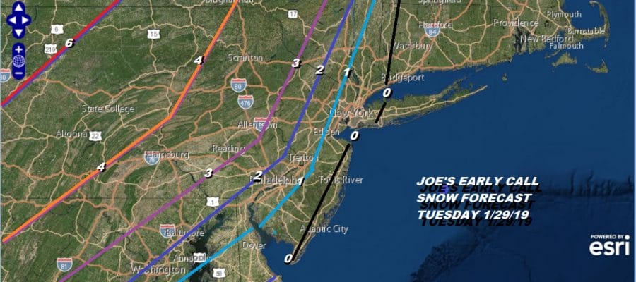
Arctic Front Tuesday Rain Changing to Snow Bitter Cold Follows
The playbook ahead is about the arctic cold front that will be approaching and moving through here on Tuesday. This looks like a rain changing to snow situation for late Tuesday into Tuesday night. The precipitation with this system looks to be about a quarter to a half inch total so snow amounts will depend on the timing of the change over and how many hours of snow can you get before dry air shuts it all off later Tuesday night. It really is a race between the cold air and the precipitation.

Yesterday’s early call snow forecast map remains unchanged tonight and weather models today are coming into this idea. Winter Storm Watches are posted for several counties in Northeast Pennsylvania where there is chance for an upside surprise if the rain turns to snow fast enough. For everyone else it is pretty much a dice roll and we will just roll with the flow with the forecast.
EASTERN SATELLITE

REGIONAL RADAR

There are not weather issues tonight through Tuesday morning. Colder air is coming in tonight. To the south we can see some of the rain from the coastal storm that will pass out well to the east. High clouds are streaming northward on the satellite loop and you can seem them quickly streaming through the area tonight. This is likely to keep temperatures a little higher unless skies clear out. Most lows will be in the 20s. Monday’s highs with some sunshine will be in the 30s. Then we cloud up Tuesday with some rain coming in during the afternoon.
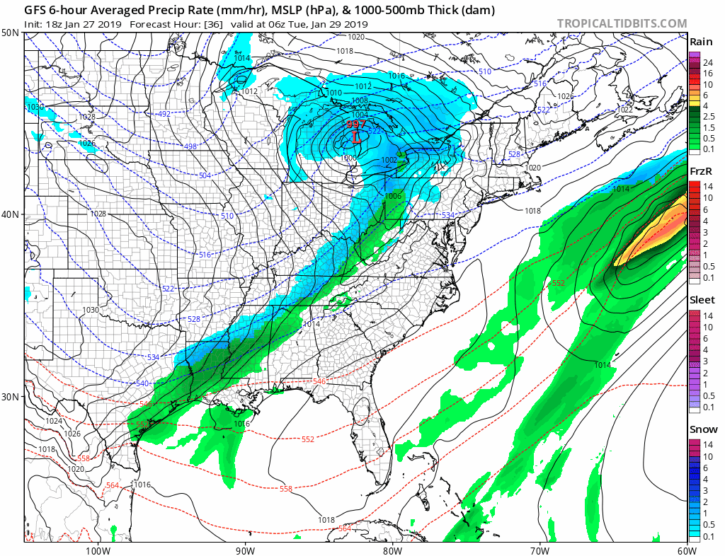
Inland areas could be colder and the snow starts Tuesday morning in Pennylvania while rain is the story further east by afternoon. Cold air will move in as the front goes by and rain changes to snow everywhere by late afternoon and evening. Then the clock ticks. How much snow falls before it shuts off? Some places will see a coating to an inch. Others see several inches or more as outlined by the early call map above. Notice that on the last frame the isobars form a V shape to the west on Wednesday. That is the true arctic boundary and when that passes some snow showers or snow squalls could occur early Wednesday afternoon. Temperatures Wednesday ease through the 20s and teens and by Thursday morning we are down in the single digits to below zero in areas north and especially west of the big cities.

The bitter cold starts to pull out Friday and the long range suggests this going to be another instance where all the cold air pulls out before it warms up and rains. There is a chance for a little snow later Friday afternoon and evening in response to warmer air arriving. The next storm comes later next weekend and by then we should he headed to the 40s with rain probably next Sunday.

MANY THANKS TO TROPICAL TIDBITS FOR THE USE OF MAPS
Please note that with regards to any tropical storms or hurricanes, should a storm be threatening, please consult your local National Weather Service office or your local government officials about what action you should be taking to protect life and property.


