Another Shot of Dry Air for Midweek
Another Shot of Dry Air for Midweek Hot Humid Late Week
We have another shot of dry air getting ready to arrive late Tuesday. The air ahead of it is dry so the amount of clouds and any showers and thunderstorms will be limited on Tuesday. You can see the cold front swinging eastward across the Ohio Valley and Great Lakes. Some scattered showers and thunderstorms are ahead of it. Tonight there are no weather issues with clear skies for the most part and most lows in the upper 50s to lower 60s though some cool spots could be a bit lower. Tuesday we think will be no worse than a mix of sun and clouds with that chance for an afternoon shower or thunderstorm in a few spots. Highs will be in the mid to upper 70s.
SATELLITE LOOP

REGIONAL RADAR

LOCAL RADAR NEW YORK CITY

LOCAL RADAR PHILADELPHIA


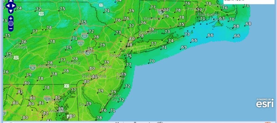
Behind the front is another shot of nice dry air for Wednesday which will be sunny and pleasant with highs in the mid to upper 70s.
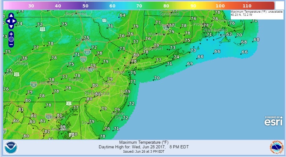
Then the high moves off the Middle Atlantic coast and we will start to warm up and gradually turn more humid. Thursday we should see sunshine with highs back in the 80s. The humidity will be a shade higher but it will still be comfortable. Then Friday will be very warm to hot with some sunshine and the risk for a late thunderstorm. Highs in the mid 80s to lower 90s. We will repeat that on Saturday. Sunday we will probably see a better chance for thunderstorms with an approaching cold front.
 GET JOE A CIGAR IF YOU LIKE

LANDSCAPE COMPANIES FOR YOUR NEEDS
LONG ISLAND ROCKLAND COUNTY Connecticut

![]()

ROCKLAND COUNTY TRI STATE SNOW REMOVAL JOHNSTOWN PA


FiOS1 News Weather Forecast For Long Island
FiOS1 News Weather Forecast For New Jersey
FiOS1 News Weather Forecast For Hudson Valley
NATIONAL WEATHER SERVICE SNOW FORECASTS
LATEST JOESTRADAMUS ON THE LONG RANGE
Weather App

Don’t be without Meteorologist Joe Cioffi’s weather app. It is really a meteorologist app because you get my forecasts and my analysis and not some automated computer generated forecast based on the GFS model. This is why your app forecast changes every 6 hours. It is model driven with no human input at all. It gives you an icon, a temperature and no insight whatsoever.
It is a complete weather app to suit your forecast needs. All the weather information you need is right on your phone. Android or I-phone, use it to keep track of all the latest weather information and forecasts. This weather app is also free of advertising so you don’t have to worry about security issues with your device. An accurate forecast and no worries that your device is being compromised.
Use it in conjunction with my website and my facebook and twitter and you have complete weather coverage of all the latest weather and the long range outlook. The website has been redone and upgraded. Its easy to use and everything is archived so you can see how well Joe does or doesn’t do when it comes to forecasts and outlooks.
Just click on the google play button or the apple store button on the sidebar for my app which is on My Weather Concierge. Download the app for free. Subscribe to my forecasts on an ad free environment for just 99 cents a month.
Get my forecasts in the palm of your hand for less than the cost of a cup of Joe!


