
Thunderstorms Around Later Today Could Get Nasty
Thunderstorms Around Later Today Could Get Nasty
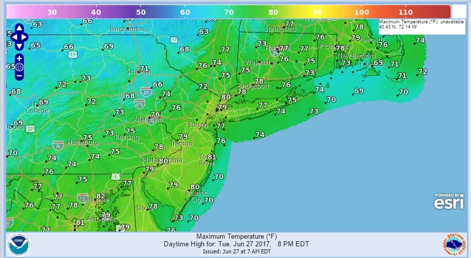
We are starting off the day with a bit of a surprise as some downpours developed overnight in Eastern Pennsylvania and parts of the area are seeing some showers this morning. We have a cold upper air trough swinging through today with the evident swirl on the satellite loop this morning. The air being very cold aloft makes for an unstable air mass. I would not be surprised to see a few scattered thunderstorms and I would also not be surprised if one or two of them get rather nasty with gusty winds and even some hail. In between all that there should be a mix of sun and clouds developing today with temperatures in the 70s to near 80.
SATELLITE LOOP

REGIONAL RADAR

LOCAL RADAR NEW YORK CITY

LOCAL RADAR PHILADELPHIA


All of this moves away tonight and skies should clear with lows in the mid 50s to lower 60s. Then its sunshine dry and delightful for Wednesday with highs in the 70s to near 80 again. The warm up begins Thursday with sunshine taking highs into the 80s. Friday it becomes very warm to hot and humid with some sunshine and then comes the risk for an afternoon or evening thunderstorm with highs in the mid 80s to lower 90s. The next cold front doesn’t approach until late Sunday so the weekend will feature very warm to hot conditions with some sun both Saturday and Sunday and of course the risk for late day thunderstorms. Highs both weekend days in the upper 80s and lower 90s.
 GET JOE A CIGAR IF YOU LIKE

LANDSCAPE COMPANIES FOR YOUR NEEDS
LONG ISLAND ROCKLAND COUNTY Connecticut

![]()

ROCKLAND COUNTY TRI STATE SNOW REMOVAL JOHNSTOWN PA


FiOS1 News Weather Forecast For Long Island
FiOS1 News Weather Forecast For New Jersey
FiOS1 News Weather Forecast For Hudson Valley
NATIONAL WEATHER SERVICE SNOW FORECASTS
LATEST JOESTRADAMUS ON THE LONG RANGE
Weather App

Don’t be without Meteorologist Joe Cioffi’s weather app. It is really a meteorologist app because you get my forecasts and my analysis and not some automated computer generated forecast based on the GFS model. This is why your app forecast changes every 6 hours. It is model driven with no human input at all. It gives you an icon, a temperature and no insight whatsoever.
It is a complete weather app to suit your forecast needs. All the weather information you need is right on your phone. Android or I-phone, use it to keep track of all the latest weather information and forecasts. This weather app is also free of advertising so you don’t have to worry about security issues with your device. An accurate forecast and no worries that your device is being compromised.
Use it in conjunction with my website and my facebook and twitter and you have complete weather coverage of all the latest weather and the long range outlook. The website has been redone and upgraded. Its easy to use and everything is archived so you can see how well Joe does or doesn’t do when it comes to forecasts and outlooks.
Just click on the google play button or the apple store button on the sidebar for my app which is on My Weather Concierge. Download the app for free. Subscribe to my forecasts on an ad free environment for just 99 cents a month.
Get my forecasts in the palm of your hand for less than the cost of a cup of Joe!


