Another Nice Summer Day
Another Nice Summer Day
[brid video=”54392″ player=”6390″ title=”Typical Mid July Weather Ahead. Forecast and Long Range Outlook”]
We continue to enjoy another nice summer day and some beautiful mid July weather with low humidity and lots of sunshine. Some high clouds are showing up on the satellite loop this morning to the north and west. But other than that we see no issues today. Highs will reach the 80s today everywhere. Tonight we have no issues either as skies should be mostly clear with lows in the 60s.
Another Nice Summer Day
Satellite Loop

You can see the upper air disturbance in the Western Great Lakes. That system comes east on Wednesday. It will turn more humid with sunshine to start but some clouds arriving later in the day. Highs will be in the 80s. Now as we transition over to a more humid air mass look for the radar loops below to begin to show some activity to the west later Wednesday and there might be a shower or thunderstorm Wednesday night. But for now the radars remain silent.
Another Nice Summer Day
Radar Loops


Thursday Friday Outlook
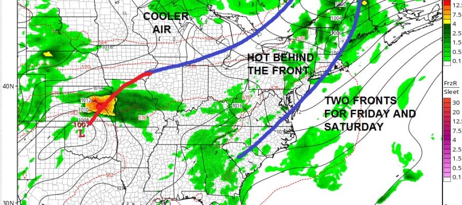
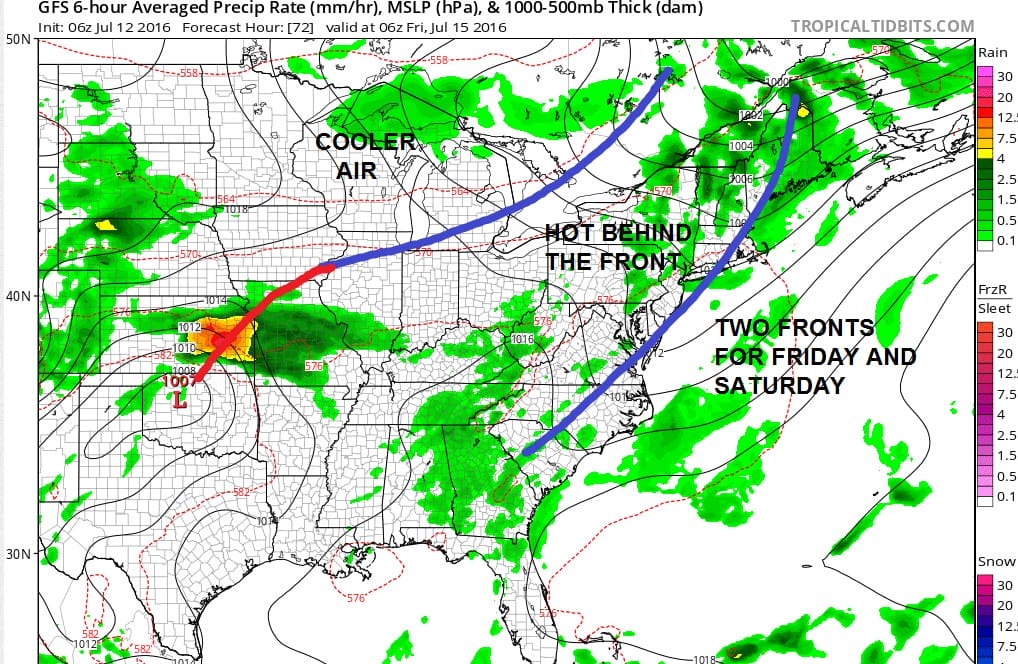
Thursday will be very warm and humid with highs in the 80s and the risk for passing showers and thunderstorms. A cold front moves through and then Friday we will have a mix of sun and clouds. Now friday we will be behind a front. Humidity levels will drop Friday and temperatures will rise into the lower 90s so Friday will be the hottest day of the week.
GFS SURFACE MAP EARLY FRIDAY MORNING
GFS DEW POINTS FRIDAY AFTERNOON

The northwest flow behind the cold front Friday dries out and heats up the atmosphere. Thats why we will see hotter temperatures behind the front rather than ahead of it. Dew points on Friday afternoon drop into the 50s which is nice and dry.
Now there is a second front that will approach and set up a chance for some rain or showers at some point over the weekend though I’m still not sure of the timing at this point. More on this later today.
FiOS1 News Weather Forecast For Long Island
FiOS1 News Weather Forecast For New Jersey
FiOS1 News Weather Forecast For Hudson Valley
NATIONAL WEATHER SERVICE SNOW FORECASTS
LATEST JOESTRADAMUS ON THE LONG RANGE
Weather App

Don’t be without Meteorologist Joe Cioffi’s weather app. It is really a meteorologist app because you get my forecasts and my analysis and not some automated computer generated forecast based on the GFS model. This is why your app forecast changes every 6 hours. It is model driven with no human input at all. It gives you an icon, a temperature and no insight whatsoever.
It is a complete weather app to suit your forecast needs. All the weather information you need is right on your phone. Android or I-phone, use it to keep track of all the latest weather information and forecasts. This weather app is also free of advertising so you don’t have to worry about security issues with your device. An accurate forecast and no worries that your device is being compromised.
Use it in conjunction with my website and my facebook and twitter and you have complete weather coverage of all the latest weather and the long range outlook. The website has been redone and upgraded. Its easy to use and everything is archived so you can see how well Joe does or doesn’t do when it comes to forecasts and outlooks.
Just click on the google play button or the apple store button on the sidebar for my app which is on My Weather Concierge. Download the app for free. Subscribe to my forecasts on an ad free environment for just 99 cents a month.
Get my forecasts in the palm of your hand for less than the cost of a cup of Joe!

MENTION JOE CIOFFI AND GET A 5% DISCOUNT


