
Alberto Heading North Flood Watches Florida to Louisiana
Alberto Heading North Flood Watches Florida to Louisiana
TROPICAL STORM WATCH POSTED ON THE GULF COAST
NORTHWEST FLORIDA TO SOUTHEAST LOUISIANA
...TROPICAL STORM AND STORM SURGE WATCHES ISSUED FOR THE
NORTH-CENTRAL GULF COAST...
...HEAVY RAINFALL EXPECTED TO AFFECT THE YUCATAN PENINSULA...WESTERN
CUBA...FLORIDA...AND THE NORTHEASTERN GULF COAST THROUGH THE
WEEKEND...


SUMMARY OF 400 PM CDT...2100 UTC...INFORMATION
----------------------------------------------
LOCATION...19.4N 86.3W
ABOUT 85 MI...135 KM SSE OF COZUMEL MEXICO
ABOUT 195 MI...315 KM SSW OF THE WESTERN TIP OF CUBA
MAXIMUM SUSTAINED WINDS...40 MPH...65 KM/H
PRESENT MOVEMENT...E OR 90 DEGREES AT 2 MPH...4 KM/H
MINIMUM CENTRAL PRESSURE...1005 MB...29.68 INCHES


WATCHES AND WARNINGS
--------------------
CHANGES WITH THIS ADVISORY:

A Storm Surge Watch has been issued for portions of the northern
Gulf Coast of the United States from Horseshoe Beach, Florida,
westward to the Mouth of the Mississippi River.

A Tropical Storm Watch has been issued for portions of the northern
Gulf Coast of the United States from Indian Pass, Florida, westward
to Grand Isle, Louisiana, including Lake Pontchartrain, Lake
Maurepas, and metropolitan New Orleans.

SUMMARY OF WATCHES AND WARNINGS IN EFFECT:

A Storm Surge Watch is in effect for...
* Horseshoe Beach to the Mouth of the Mississippi River

A Tropical Storm Watch is in effect for...
* Tulum to Cabo Catoche Mexico
* Cuban province of Pinar del Rio
* Indian Pass to Grand Isle
* Lake Pontchartrain and Lake Maurepas

The look of Alberto appears to be a bit ragged which is typical of subtropical cyclones. Strong upper air winds are still occurring but those winds are forecast to relax over the weekend as Alberto moves northward. Right now the big issue is rain that is moving through Central & South Florida with some heavy rains along the Florida West Coast. Several inches of additional rain or more is forecast over the weekend on top of heavy rain that fell last week so flooding will be front and center here.
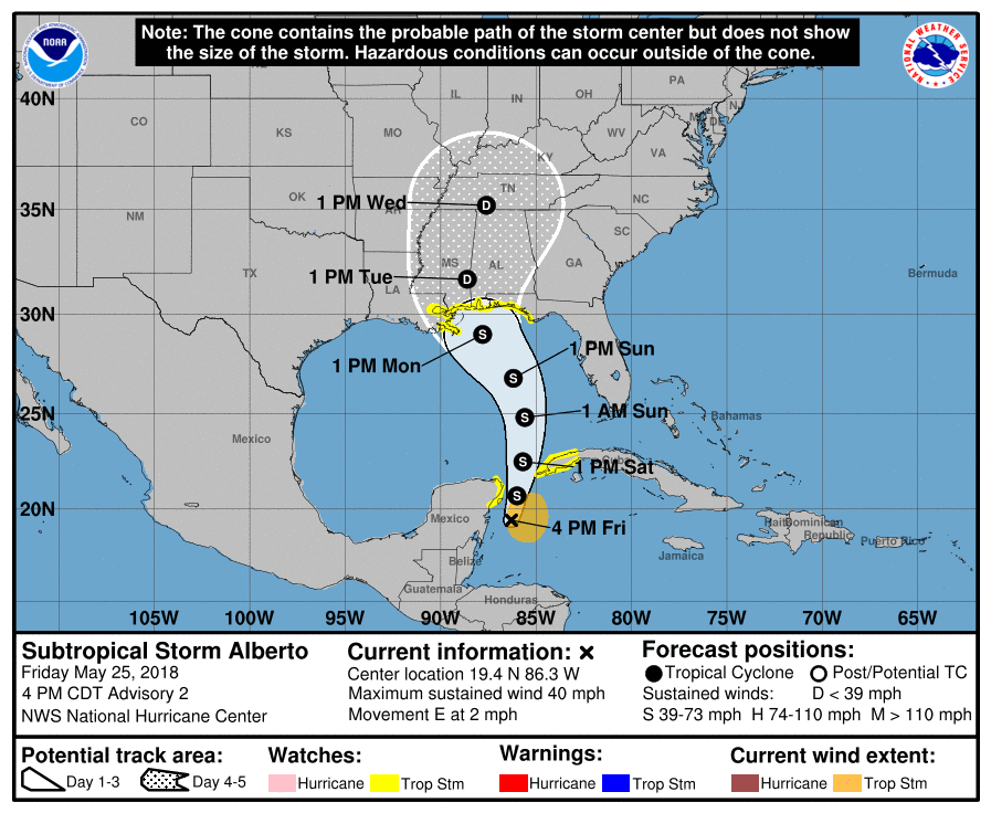
There isn’t much change in the Hurricane Center’s forecast. The watch area is highlighted in yellow and extends from Northwest Florida to Southeast Louisiana. We will continue to monitor this through the weekend. There is no threat to our area from this over the Memorial Day Weekend. We have our own issues with a cold front stalling out to our south with an onshore flow for Sunday and Monday and some on and off showers. Saturday continues to look very warm to hot with highs near 90 inland..cooler along the shower and the chance for an evening thunderstorm.
FiOS1 News Weather Forecast For Long Island
FiOS1 News Weather Forecast For New Jersey
FiOS1 News Weather Forecast For Hudson Valley