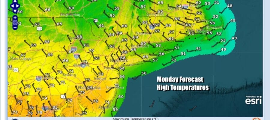
Work Week Begins With 2 Days of Sunshine
Next Cold Front & Showers Late Wednesday into Thursday

Work Week Begins With 2 Days of Sunshine
Next Cold Front & Showers Late Wednesday into Thursday
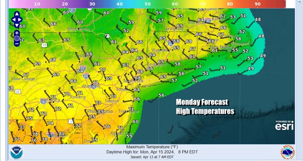
Sunday’s cold front has now passed offshore and we begin this week with quiet weather for a change. No major storms are on the horizon for this week in the Northeast and Middle Atlantic states. We do have two cold fronts to contend with later in the week and into next weekend and we will get to those in a moment. Today across Eastern Pennsylvania to Southern New England we see a nice day of sunshine. Also the air behind the cold front that has passed isn’t really cold and the strong April sun should take high temperatures to the upper 60s and lower 70s with just local sea breezes at the coast.
SATELLITE WITH LIGHTNING STRIKES

WEATHER RADAR

Winds have been strong and gusty for days are actually going to ease somewhat today as the pressure gradient in the Northeast and Northern Mid Atlantic relaxes somewhat. We have no weather issues tonight and Tuesday is shaping up like a nice day with sunshine and high temperatures again reaching into the 70s in areas inland while ocean breezes will keep things a little cooler at the coast.

Storm tracks this week will shift to the west and northwest and this is good news because it takes the East Coast out of the path of heavy rain storms that have been a regular occurrence for the last several months and have put rainfall amounts on a record pace so far this year. Severe weather risks and elevated tornado risk shift to the Plains today from Texas to Nebraska, the Mississippi and Missouri River Valley from Louisiana to Iowa Wednesday, and into the Ohio Valley Thursday.

Low pressure from the Western Plains heads to the Great Lakes in a weaker form and its trailing cold front will approach later Wednesday into early Thursday and we will see clouds increasing Wednesday and some showers Wednesday night through at leas part of Thursday. Wednesday highs will range from the 50s right along the immediate coast to upper 60s and and lower 70s well inland.

Once showers move out later Thursday it leaves us with a dry Friday and highs in the low to middle 60s for the moat part. Some sunshine will give way to arriving clouds. A second cold front passes Friday night or early Saturday and it is beginning to appear that this front won’t have much with it. As long as a wave developing on the front stays to our south, it will leave us with a nice weekend with temperatures on the cool side of normal but without any rain issues.
BE SURE TO DOWNLOAD THE FREE METEOROLOGIST JOE CIOFFI WEATHER APP &
ANGRY BEN’S FREE WEATHER APP “THE ANGRY WEATHERMAN!
MANY THANKS TO TROPICAL TIDBITS FOR THE USE OF MAPS
Please note that with regards to any severe weather, tropical storms, or hurricanes, should a storm be threatening, please consult your local National Weather Service office or your local government officials about what action you should be taking to protect life and property.
(Amazon is an affilate of Meteorologist Joe Cioffi & earns commissions on sales.)


