
Severe Weather Risk Late Today Into Tonight
Showers Thunderstorms As Cold Front Passes

Severe Weather Risk Late Today Into Tonight
Showers Thunderstorms As Cold Front Passes

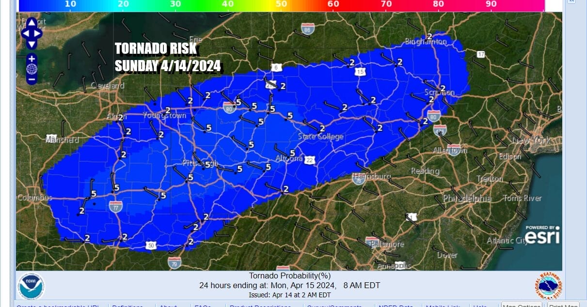
One storm system has finally pulled out to the east but as quickly as it moves out, we have another system that is moving into today into the Northeast and this is creating severe weather risk per the Storm Prediction Center. An enhanced risk for severe weather extends from Southeast Ohio into Northeast Pennsylvania. Elevated tornado risk exists mainly in the enhanced and slight risk zones of 2 to 5 percent.
Ahead of all this today we will have sunshine into this afternoon with a west wind and temperatures that are going to warm up quiet nicely. The satellite loops are showing the catalyst for severe weather in the form of a short wave trough heading southeast from the Great Lakes and moving across New York State and into New England this afternoon.
SATELLITE WITH LIGHTNING STRIKES

WEATHER RADAR

The trailing cold front will see showers and thunderstorms develop along it but the main risk for thunderstorms and severe weather will be west and north of New York City. Still there is limited risk extending into Long Island and Southwestern New England. As for temperatures today, with sunshine into the afternoon, highs will reach the mid to upper 60s east of New York City to Southern New England and Long Island.

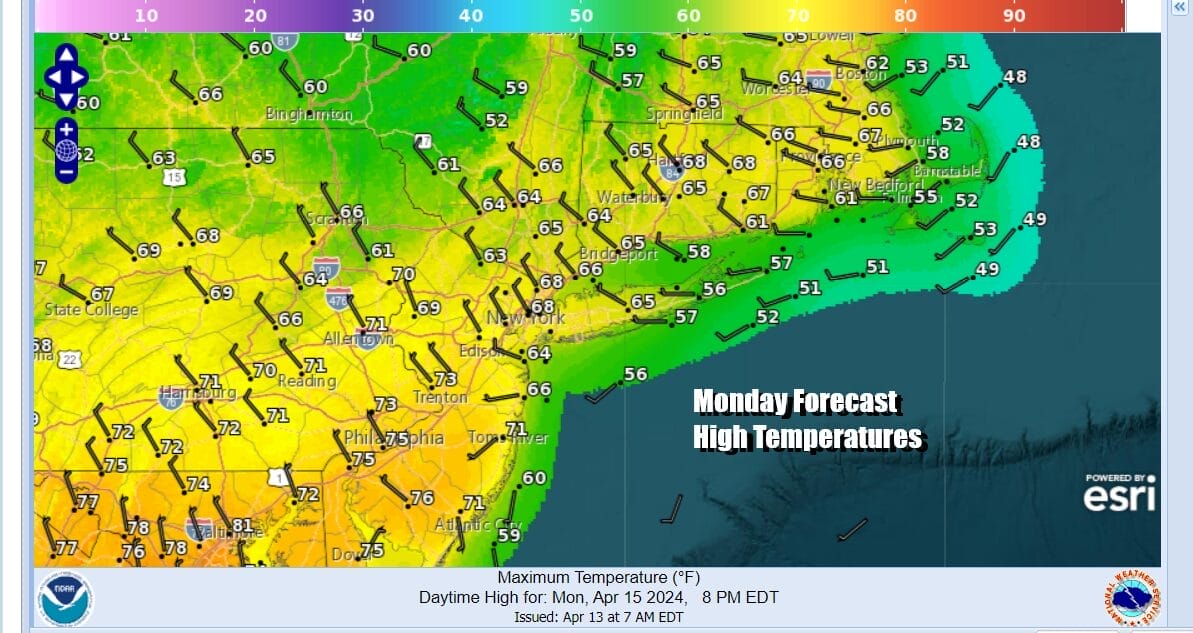
High temperatures for New Jersey westward into Pennsylvania will reach into the 70s. Thunderstorms play through this evening and then move offshore and skies should clear out later tonight. Most lows will be in the 50s. Monday we will see sunshine return and it should be a nice warm-ish spring day. Highs will reaching into the 70s in many locations.
While we do have a slightly calmer week ahead of weather with no major storms, we still will have weather systems to deal with. The first looks to come Wednesday in the form in a cold front as low pressure heads to the Great Lakes. The second comes along late in the week or possibly Saturday. For now we don’t see anything crazy as far as rain is concerned.

Tuesday should be a decent day of sunshine and a few clouds with highs mostly in the mid 60s to lower 70s except for cooler temperatures near south and east facing shorelines where the sea breeze will take hold. Wednesday we see the chance for showers with a cold front late int the day and lasting into at least part of Thursday. This will be followed by another system for later Friday night and Saturday so perhaps we will squeeze in some dry time in between.
BE SURE TO DOWNLOAD THE FREE METEOROLOGIST JOE CIOFFI WEATHER APP &
ANGRY BEN’S FREE WEATHER APP “THE ANGRY WEATHERMAN!
MANY THANKS TO TROPICAL TIDBITS FOR THE USE OF MAPS
Please note that with regards to any severe weather, tropical storms, or hurricanes, should a storm be threatening, please consult your local National Weather Service office or your local government officials about what action you should be taking to protect life and property.
(Amazon is an affilate of Meteorologist Joe Cioffi & earns commissions on sales.)


