
Weekend Sees One System Leaving & Another Arriving
Severe Weather Risk New Jersey Westward Sunday

Weekend Sees One System Leaving & Another Arriving
Severe Weather Risk New Jersey Westward Sunday
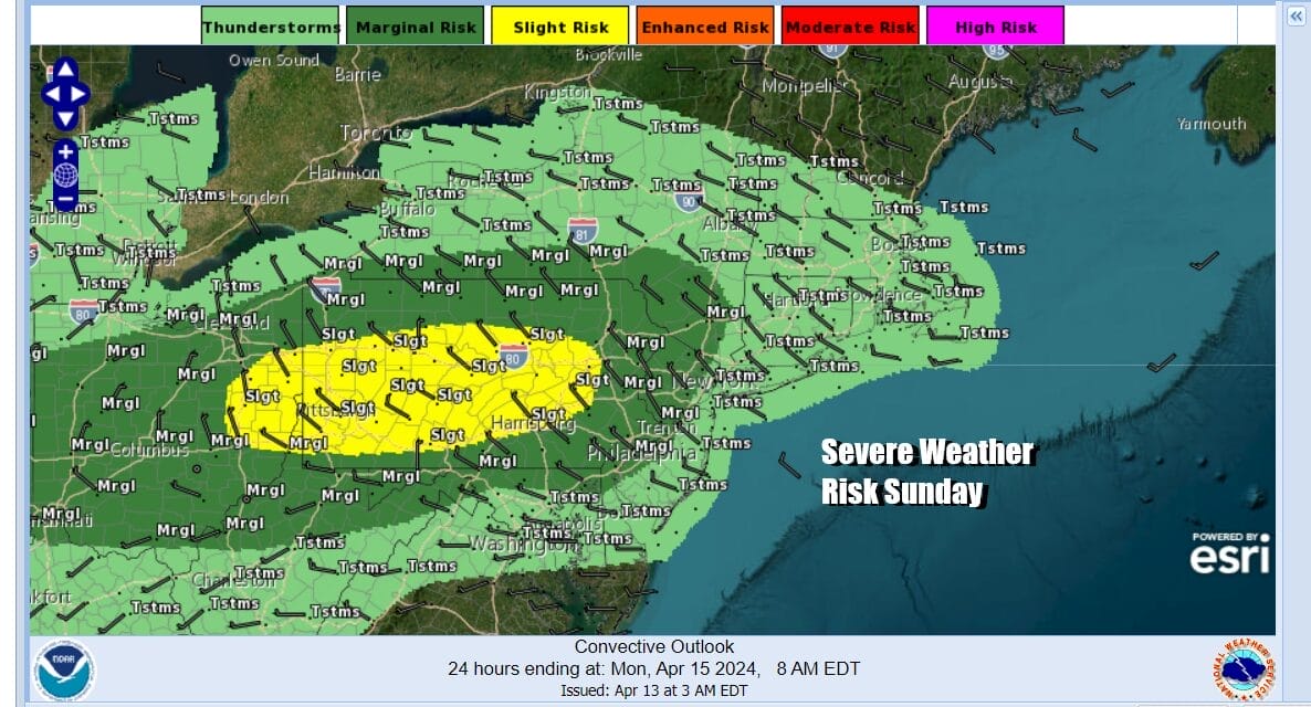
This is a weekend which sees one storm system departing today and another weather system with a cold front arriving late tomorrow so the trick is going to be enjoying the dry time in between. We have lots of clouds in the Northeast as we wait for an upper trough to finally clear the coast but this is going to be a slow process today. In the meantime we have another cold front coming late Sunday afternoon into Sunday night that could set off some rain and thunderstorms and this comes with severe weather risk for areas inland from New Jersey west into Pennsylvania and south into Maryland.
SATELLITE WITH LIGHTNING STRIKES

WEATHER RADAR

Meanwhile back to today we have clouds and we have some clusters of light showers on the radar that should move from west to east and exit so look improvement this afternoon with decreasing clouds and increasing amounts of sun (hopefully) Gusty west to northwest winds will continue into the afternoon before easing a bit and highs should reach the mid to upper 50s, Some warm spots could get to 60 or so.
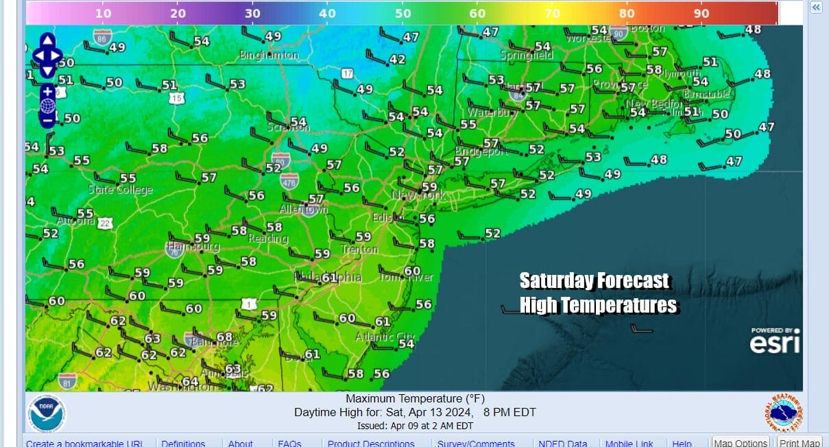
We should clear out tonight with lows mainly in the 40s, Sunday we will warm up ahead of the cold front that is dropping southeast from the Great Lakes. We should have sunshine during the morning and early afternoon before clouds increase from the west and northwest and we see the development of showers and a few thunderstorms late in the day into Sunday night.
 If this plays out according to plan Sunday highs should reach the mid to upper 60s north and northeast of NYC with lower 60s in much of Southern New England. To the southwest of NYC highs should reach into the 70s. We will see the cold front move through Sunday night and any showers and thunderstorms will come to an end. Monday looks like a nice spring day with developing sunshine and highs in the upper 60s to middle 70s.
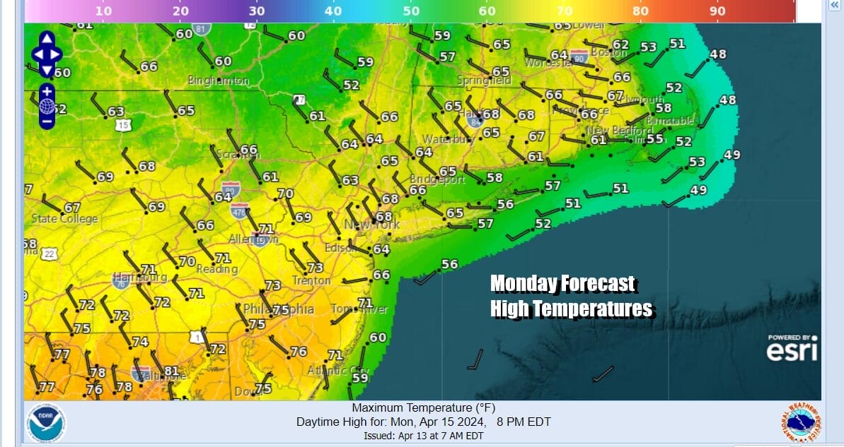
Tuesday looks a like a nice day overall with sunshine and highs in the upper 60s to lower 70s. The next storm develops in the Plains and heads northeast into the Western Great Lakes Monday and Tuesday. Severe weather risk will be rather widespread in all of the Plains from Texas to Nebraska Monday and up and down the Mississippi Valley Tuesday. This will lead to the risk for some showers in the Northeast and Middle Atlantic Wednesday but we are not expecting anything major at this stage of the game.

BE SURE TO DOWNLOAD THE FREE METEOROLOGIST JOE CIOFFI WEATHER APP &
ANGRY BEN’S FREE WEATHER APP “THE ANGRY WEATHERMAN!
MANY THANKS TO TROPICAL TIDBITS FOR THE USE OF MAPS
Please note that with regards to any severe weather, tropical storms, or hurricanes, should a storm be threatening, please consult your local National Weather Service office or your local government officials about what action you should be taking to protect life and property.
(Amazon is an affilate of Meteorologist Joe Cioffi & earns commissions on sales.)


