
Wintry Mix Possible Sunday Night Into Monday Morning Inland
Quiet Weekend Ahead of Two Storm Systems For Next Week

Wintry Mix Possible Sunday Night Into Monday Morning Inland
Quiet Weekend Ahead of Two Storm Systems For Next Week
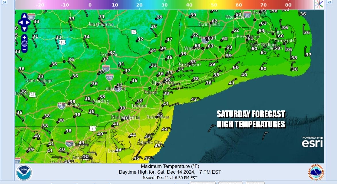
The weekend begins and today, Saturday, is going to be the better of the two weekend days. We have high pressure along the East Coast and no issues today other than a few passing clouds. Plenty of sunshine will edge temperatures a touch higher this afternoon as highs reach the mid 30s to near 40 degrees. Local radars are nice and quiet. Tonight skies should be mainly clear and it will be very cold due to ideal radiational cooling conditions. Lows in the teens inland and near or just over 20 along the coast and warmer urban areas.
SATELLITE WITH LIGHTNING STRIKES

WEATHER RADAR

Sunday we will see sunshine giving way to increasing clouds. High pressure is going to be slow in getting out of the way and this is going to trap colder air into areas across Northeast Pennsylvania to Northern New Jersey, the Hudson Valley and Western Connecticut. Sunday highs will struggle in the low to mid 30s NYC and points west north and northeast while areas to the south in South Jersey and points southward could reach into the 40s.

Sunday night we have a warm front that will be approaching from the southwest. Since there may be some cold air left hanging around especially in inland valleys, precipitation will come in as a wintry mix of light snow and some freezing rain. This will occur mainly north and north west of Interstate 287 in New Jersey, and north of 287 in Westchester County NY. Precipitation will be light but there will likely be some slick spots developing for the Monday morning commute.

For areas in Southeastern Pennsylvania and Southern New Jersey it will be just a little bit of rain that will play through. The high pressure cell moves far enough east to allow the warm front to gradually push northward so precipitation ends Monday morning as some light rain or drizzle. Then we have a second push from a cold front to the west and that brings some showers through Monday night.

Temperatures Monday will reach the low and mid 50s well to the south across Southern New Jersey with40s everywhere else. It may take all day for the warm front to push north of NYC and into Northern New Jersey and the Hudson Valley as well as Connecticut. Showers Monday night will be long gone by daybreak Tuesday and we will see sunshine along with very warm temperatures. Highs will be in the upper 50s and lower 60s.

Wednesday appears to be a dry weather day with temperatures in the 50s and some sunshine and arriving clouds. The next cold front will pass Wednesday night with just clouds but we will be watching a wave that will be developing along the front. This could bring a chilly raw rainy day for Thursday. This will be followed by another shot of colder air dropping southeast from Canada for Friday and next weekend which looks to be mostly precipitation free.
BE SURE TO DOWNLOAD THE FREE METEOROLOGIST JOE CIOFFI WEATHER APP &
ANGRY BEN’S FREE WEATHER APP “THE ANGRY WEATHERMAN!
MANY THANKS TO TROPICAL TIDBITS FOR THE USE OF MAPS
Please note that with regards to any severe weather, tropical storms, or hurricanes, should a storm be threatening, please consult your local National Weather Service office or your local government officials about what action you should be taking to protect life and property.


