
Winter Weather Advsiories Inland Rain Along Coast Very Cold Late Week Weekend
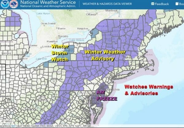
We have Winter Weather Advisories in effect for inland areas in Northwest New Jersey (Sussex & Warren Counties) Northeast Pennsylanvia, northeast the the Hudson Valley north of 84 and Northwest Connecticut. To the south we also have Winter Weather Advisories for South Central Pennsylvania mainly west of I-81.

This is the first winter weather system of the very young season and in areas where we have advisories, it will not amount to much. We are looking for at most a coating to an inch or so of snow and sleet before changing to rain. Areas in upstate NY north of I-90 and west of I-91 stand a chance to see up to several inches of accumulation, perhaps 4 or 5 inches possible in some “jackpot” areas that always develop in these situations. Outside of the advisory areas it is rain on the order of 3/4 inch to 1.25 inches.

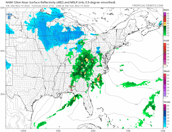
Clouds will be increasing as the day wears on and you can see the bright white cloud tops to the west. Clouds will thicken up and preicpitation is now increasing on the radar to the west and southwest. Look for rain to develop from south to north late today into this evening. As the rain advances into the remaining cold air inland we will see it start as wet snow and/or sleet before changing to rain tonight. Overall for Eastern Pennsylvania to Southern New England where advisories are posted, this is not a big deal.
SATELLITE

WEATHER RADAR

Temperatures today will top in the 40s but the highs of the day may not come until before midnight. Inland temperatures will be in the 30s to near 40 and then also rise overnight as warmer air comes in. Rain overnight will last into Wednesday morning but it should be ending from southwest to northeast around daybreak.
As weather conditions improve Wednesday we will have developing sunshine and temperatures that will be topping in the upper 40s and lower 50s. Beyond Wednesday a very cold (for this time of year) weather pattern will be setting up for the eastern half of the US. This may also come with a long duration lake effect snowstorm for parts of Western and Northern NY where Winter Storm Watches are already up and snow will be measured in feet in those areas! Thursday and Friday we will see a mix of sun and clouds as upper troughs will be swinging through. Highs will be in the 40s Thursday. Temperatures will trend south Friday with most highs just in the low to mid 40s. Over the weekend it will be cold with some sunshine both days but daytime highs will only be in the upper 30s and lower 40s. Nights will be progressively colder as well. Once we are done with this storm system, no storm systems will be impacting our weather through the weekend and into the start of next week.
BE SURE TO DOWNLOAD THE FREE METEOROLOGIST JOE CIOFFI WEATHER APP &
ANGRY BEN’S FREE WEATHER APP “THE ANGRY WEATHERMAN!
MANY THANKS TO TROPICAL TIDBITS & F5 WEATHER FOR THE USE OF MAPS
Please note that with regards to any severe weather, tropical storms, or hurricanes, should a storm be threatening, please consult your local National Weather Service office or your local government officials about what action you should be taking to protect life and property.


