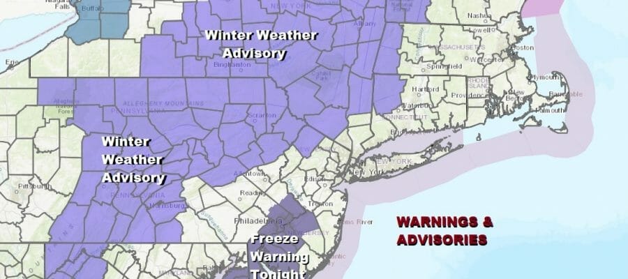
Winter Weather Advisory Hudson Valley NW New Jersey Northeast Pa Catskills

Winter Weather Advisories are posted for late Tuesday into Tuesday night. This is for parts of South Central Pennsylvania (mainly west of I-81) north and east to Northeast Pennsylvania, Northwest NJ (Sussex County), the Catskills and the Hudson Valley (Orange & Dutchess County) northward to the I-90 corridor.
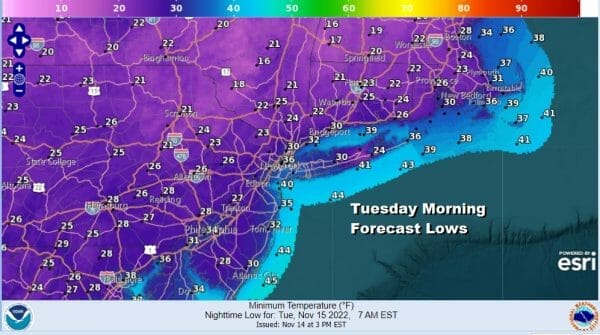
We also have freeze warnings for Southern New Jersey, Southeast Pennsylvania, and Delaware as they are one of the few remaining areas left that have not seen a freeze. There are no issues tonight as we will have clear skies and cold temperatures down to the 20s and lower 30s. Cold spots will radiate into the teens.
SATELLITE

WEATHER RADAR

Weather conditions will deteriorate Tuesday as low pressure comes out of the Gulf States and heads up to the Mid Atlantic coast and eventually New England. Look for increasing clouds during the day with highs reaching the upper 30s and lower 40s. Snow will develop in the advisory areas late Tuesday into Tuesday evening as moisture moves over the remaining cold air that is wedged into the Northeast and Northern Mid Atlantic.

The HRRR model is the one we are using today and it matches up well with some of the others. The loop starts at 1pm Tuesday and ends at 7am Wednesday. For the coast it is a cold raw rain with snow inland. Snow develops across Pennsylvania mid to late afternoon and into the Hudson Valley (north of Route 84) in the early evening. This system moves fast. Areas south of I-90 in New York State will change over to rain from south to north. It is all comes to an end Wednesday morning.

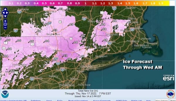
National Weather Service updated snow and ice forecasts have been issued. Most snow amounts will be in the 1 to 3 inch range however there are pockets of 4 inches or more north of I-90 in upstate NY. These numbers appear reasonable. Ice accumulation of up to a tenth of an inch is possible in Northern and Northeast PA as well as in the Catskills. Also we could see some minor ice accretion in NW Connecticut and Western Massachusetts.
BE SURE TO DOWNLOAD THE FREE METEOROLOGIST JOE CIOFFI WEATHER APP &
ANGRY BEN’S FREE WEATHER APP “THE ANGRY WEATHERMAN!
MANY THANKS TO TROPICAL TIDBITS & F5 WEATHER FOR THE USE OF MAPS
Please note that with regards to any severe weather, tropical storms, or hurricanes, should a storm be threatening, please consult your local National Weather Service office or your local government officials about what action you should be taking to protect life and property.


