
Below Average Temperatures Next 10 Days
Cold Rain Late Tuesday Into Wednesday Snow Upstate NY New England
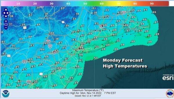
The week ahead is going to be much different than last week’s warm weather as the colder pattern across the Eastern US and much of North America is now in control and will probably last into early next week. It seems that we will see temperatures running 5 to 10 degrees below average through this stretch. That means many days where highs will just be in the 40s and on some days barely so. Today is one of those days as cold air has settled in and we will see sunsihne. Most highs today will be in the middle to upper 40s. Much of the precipitation activity on the radar is gone other than a little bit of lake effect in Upstate NY.
WEATHER RADAR

We have a cold clear night ahead with light winds and that should take lows down to the 20s and perhaps even a few teens in isolated cold spots and lower 30s coast and warmer urban locations. Tuesday we see increasing clouds as the next storm system moving across the south today and tonight turns northward up the coast.

A set up like this a few weeks from now would probably be a snow issue even for the coastal areas and while it is cold going into this, it is just now quite cold enough. I think this could be a several inches or more snow producer for areas in upstate NY and into New England north of Interstate 90.
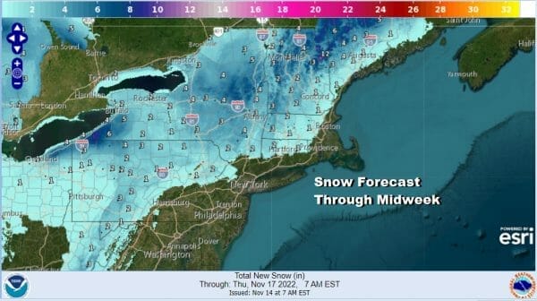
To the south down to Route 84 we could see an area where precipiation starts off as snow or sleet before going to rain. Northwest New Jersey and Northeastern Pennsylvania could see snow at the start as well, some areas night get a coating to an inch or so.

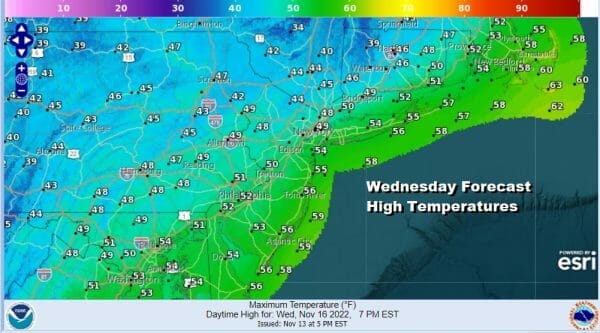
For Eastern Pennsylvania to Southern New England look for arriving clouds Tuesday with highs just in the 40s. Rain develops from south to north later Tuesday afternoon and evening and comes to end by Wednesday morning. This will leave us with improving weather conditions Wednesday with clouds giving way to some sunshine. Highs will be in the upper 40s inland and lower 50s near the coast.
A cold dry pattern takes hold Thursday and probably lasts through the weekend and into next week. We will see temperatures each day average about 10 or so degrees below average with highs Thursday and Friday in the low to mid 40s and weekend highs (Saturday and Sunday) will be in the lower 40s. Models have backed away from the idea of another storm system possibly heading here late Sunday into Monday so for now at least it looks dry and cold into Thanksgiving week.
BE SURE TO DOWNLOAD THE FREE METEOROLOGIST JOE CIOFFI WEATHER APP &
ANGRY BEN’S FREE WEATHER APP “THE ANGRY WEATHERMAN!
MANY THANKS TO TROPICAL TIDBITS & F5 WEATHER FOR THE USE OF MAPS
Please note that with regards to any severe weather, tropical storms, or hurricanes, should a storm be threatening, please consult your local National Weather Service office or your local government officials about what action you should be taking to protect life and property.


