Cold Air Below Average Temperatures All Week
Cold Rain Tuesday Night Wednesday
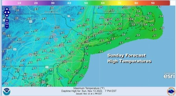
The upper trough and cold front moving through is bringing in colder air that will be with us all of next week. Showers overnight and this morning are moving to the east. This will lead to decreasing clouds this afternoon with a gusty wind. Temperatures in most places will settle in the 40s while to the east highs will be in the 50s and then they will settle back later today. We see showers along the coast from Maine to Delmarva on the radar and they will eventually slide out offshore.
SATELLITE

WEATHER RADAR

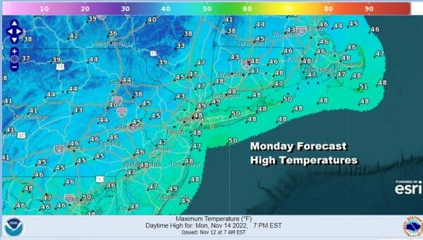
Skies will clear out overnight and it will be cold. Overnight lows will be in the mid to upper 20s inland and low to middle 30s coast and warmer urban settings. A cold high builds in Monday from the north and that will give us a sunny but cold day. Highs will just be in the 40s.
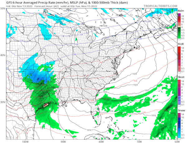
Another cold night lies ahead for Monday night into Tuesday morning with lows again in the mid 20s to lower 30s. Tuesday look for increasing clouds as we have low pressure moving across the south. Rain will spread across the Deep South and some snow will fall from parts of the Southern Plains to the Ohio Valley and Great Lakes. Tuesday highs will be just in the 40s.

This low will not be a particularly strong one so we aren’t exactly looking for anything significant either rain or snow wise but the cold pattern does yeild its first snows for parts of Northern Pennsylvania, Upstate NY, and Northern New England. A cold rain develops from south to north late Tuesday from south to north for much of Eastern Pennsylvania to Southern New England.
Areas north of route 80 in Pennsylvania, and north of Route 84 across NY and Connecticut could see some wet snow or sleet at the start Tuesday night. The system moves along and rain should be ending from west to east Wednesday morning with colder drier air coming in for the rest of the week.
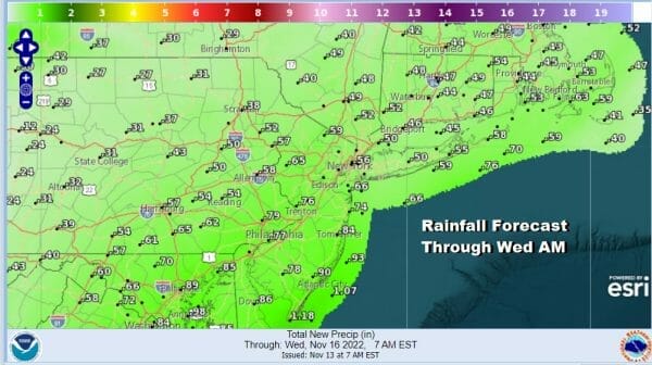

Rain and snowfall forecast amounts carry us through Wednesday morning so there may be additional rain or snow to add to these numbers before it is all said and done especially for the snow amounts forecast for Northern New England. Longer range we don’t see much happening into the weekend however we may be looking at a storm system for next Sunday/Monday to kick off Thanksgiving week.
BE SURE TO DOWNLOAD THE FREE METEOROLOGIST JOE CIOFFI WEATHER APP &
ANGRY BEN’S FREE WEATHER APP “THE ANGRY WEATHERMAN!
MANY THANKS TO TROPICAL TIDBITS & F5 WEATHER FOR THE USE OF MAPS
Please note that with regards to any severe weather, tropical storms, or hurricanes, should a storm be threatening, please consult your local National Weather Service office or your local government officials about what action you should be taking to protect life and property.


