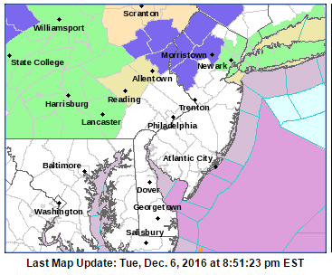
Winter Weather Advisory Expanded In New Jersey
Winter Weather Advisory Expanded In New Jersey
Winter Weather Advisory in Effect for Sussex County has now been expanded southward due to a mix of snow sleet and freezing rain. Elevated areas could see 3 to 5 inches. Elsewhere in the neighboring counties there could be a couple of inches possible in elevated areas. The advisory now includes Morris, Warren, & Hunterdon Counties.
...WINTER WEATHER ADVISORY IN EFFECT UNTIL 1 AM EST WEDNESDAY...

THE NATIONAL WEATHER SERVICE IN MOUNT HOLLY HAS ISSUED A WINTER
WEATHER ADVISORY FOR FREEZING RAIN...WHICH IS IN EFFECT UNTIL 1
AM EST WEDNESDAY.

* ACCUMULATIONS...MINOR SNOW AND SLEET ACCUMULATIONS...ALONG WITH
  AROUND A TRACE OF ICE.

* LOCATIONS...PORTIONS OF THE LEHIGH VALLEY AND NORTHERN NEW
  JERSEY.

* ICE ACCUMULATIONS...AROUND A TRACE.

* TIMING...FREEZING RAIN IS ONGOING IN SPOTS AND WILL CONTINUE FOR
  THE NEXT SEVERAL HOURS, TEMPERATURES WILL WARM ABOVE FREEZING
  OVERNIGHT.

* IMPACTS...ICE AND SNOW ACCUMULATIONS MAY CREATE SLIPPERY ROAD
  CONDITIONS AND SIDEWALKS.

* WINDS...NORTHEAST 5 TO 10 MPH.

* TEMPERATURES...IN THE LOW 30S.

* VISIBILITIES...ABOVE ONE MILE.

PRECAUTIONARY/PREPAREDNESS ACTIONS...


The radars are also loaded with precipitation that is moving northeastward. The back edge is moving out of Virginia and Maryland. We should begin to see this start to wind down during the early morning hours and it all should be done by daybreak.
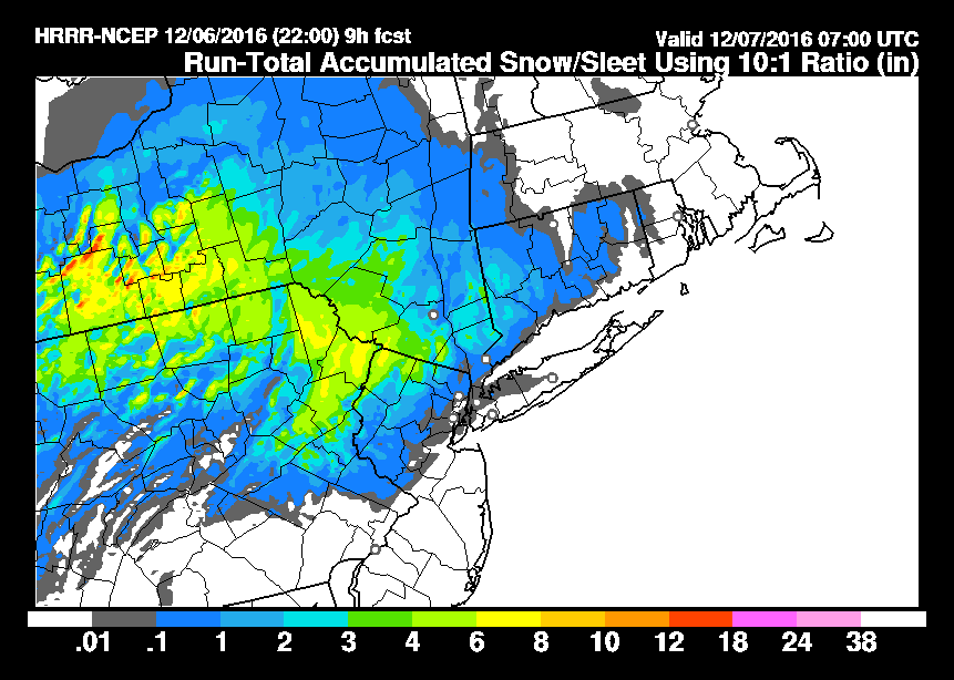
The maps below are the National Weather Service forecast snow maps with the most likely snowfall prediction. They have been adjusted somewhat higher in some places but check the time stamp. These maps were updated as of 7pm. They will update automatically so check back later to see new forecasts.


Weather conditions will improve later tonight as all of this moisture moves away to the east. We should see clouds giving way to some breaks of sun on Wednesday before a cold front arrives on Thursday with a few rain or snow showers. After that front passes it will turn much colder for Friday and the weekend with temperatures not out of the 30s for highs and nights down in the upper teens to low 20s into Sunday.


