Winter Weather Advisories Northeastern Pennsylvania Northern New Jersey
Hudson Valley Western Connecticut

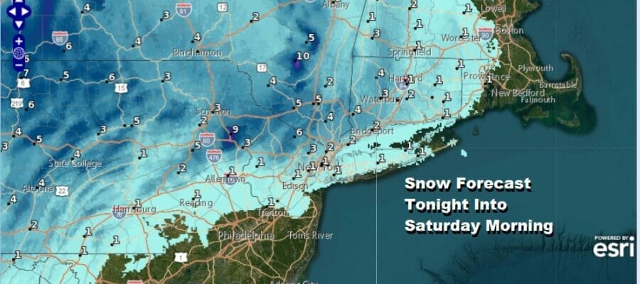
We are looking at Winter Weather Advisories for late today and overnight into Saturday morning for areas from Northeastern Pennsylvania, east to most of Northern New Jersey, the Hudson Valley east into the western half of Connecticut. 3 counties in Northeastern Pennsylvania are under Winter Storm Warnings which are Pike, Wayne, & Monroe counties.
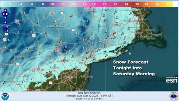
Above is the National Weather Service snow forecast which has been shaded slightly lower from last night and I agree with the lower amounts being indicated by today’s outlook. Firstly there isn’t much in the way of cold air. Also this is going to be a snowfall that will be elevation driven so if you are above 750 feet you will have a different outcome than those closer to sea level.

My snow forecast amounts are lower than the National Weather Service where I’m covering for a coating to an inch or so along coastal areas from NYC east and going for 3 to 6 inches in Northwest NJ, Northeastern Pennsylvania into western areas of the Hudson Valley and again elevation driven is key. The higher up you are the more will accumulate on all surfaces verses lower elevations which may only see accumulation on colder surfaces.
SATELLITE

WEATHER RADAR

Precipitation is increasing on the regional radar and moving eastward Look for rain to develop in areas along the coast and a mix of rain/wet snow or just wet snow inland. Then tonight wet snow will fall inland while at along the coast NYC to Long Island we will probably see rain start to mix with wet snow. Meanwhile in Central and South Jersey we will see mostly rain with some wet snow possibly mixing in by morning. Temperatures today will top in the 40s and then drop into the low and mid 30s once precipitation really gets going.

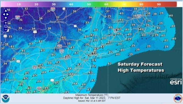
Low pressure develops offshore and strenghtens Saturday morning but it will start to move southeastward away from the coast. Precipitation Saturday morning which could me more wet snow than anything else will be ending and that will be followe by leftover clouds. Highs will reach into the 40s.
As the first storm system exits then next system comes in right behind it so there will be little time for clearing skies Saturday night because clouds will be rolling back in Sunday. Highs Sunday will be in the low to middle 40s. Precipitation will arrive Sunday night as low pressure moves out of Tennessee Valley and redevelops off the Mid Atlantic coast Sunday night & Monday.

This system looks to strengthen into a powerful storm along the East Coast and it does carry risk for heavy snow certainly for much of New England but the impacts to our area remain unclear. We will address these issues in full once this first system plays itself out.
BE SURE TO DOWNLOAD THE FREE METEOROLOGIST JOE CIOFFI WEATHER APP &
ANGRY BEN’S FREE WEATHER APP “THE ANGRY WEATHERMAN!
MANY THANKS TO TROPICAL TIDBITS & F5 WEATHER FOR THE USE OF MAPS
Please note that with regards to any severe weather, tropical storms, or hurricanes, should a storm be threatening, please consult your local National Weather Service office or your local government officials about what action you should be taking to protect life and property.


