
Coastal Storm Moving Away Later Today
Next Stronger Storm Set for Monday Night Into Tuesday
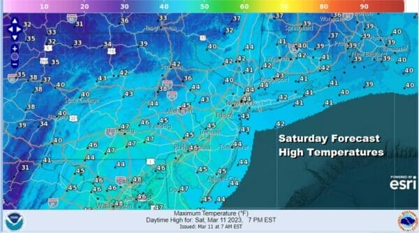
A storm system is well offshore and behaving pretty much as advertised. Precipitation will be ending as we move through the day and we will be left with just some leftover clouds. Temperatures this afternoon will rise to the 40s so slushy inland accumulations will disappear in a hurry. Skies should partially clear out tonight with lows in the mid 20s to lower 30s.

I don’t see any issues for Sunday into Sunday night as we will have high pressure building southward from Eastern Canada and New England. This should put us in position to enjoy a fair amount of sunshine, though some clouds will start to come in late in the day. Sunday highs will be in the mid to upper 40s. Enjoy the later sunsets on the first day of Daylight Saving Time.
SATELLITE

WEATHER RADAR

Monday begins what will be a long duration event as the next storm system moves across the Lower Tennessee Valley and redevelops off the North Carolina coast. Snow lovers are foaming at the mouth over this as this will be probably the last chance for anything snow wise this non-winter winter season. There are still some issues that need to be resolved.

This is looking more and more like a snowstorm for much of New England and perhaps upstate NY but this is still a little early in the game. What makes this a no go for areas along the coast from Long Island to New Jersey is that the low tracks to the east before turning north and northwest to a position near Cape Cod/Nantucket. That eastward motion early shifts the axis of heavy snow eastward. The upper features complicate matters with this as well. I expect models to start closing in on a final outcome over the next 24 hours or so. We will wait until then to come up with an early call snow forecast map when all the puzzle pieces start to fit.
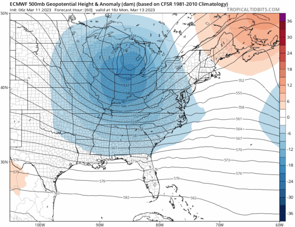
The latest round of models show the upper air storm taking a track further north than the last few days. This track shown by the European IS NOT a track favorable for a heavy snowfall for the coast of Southern New England and points south. You need the upper air low to track across Maryland to Delaware and then lift northeast to just southeast of Cape Cod. Heavy snow (6 inches or more) falls in a band 40 to 120 miles north of the track of the upper low. This track suggests the southern boundary of heavy snow will be near Route 84 from Pennsylvania to Southern New England.
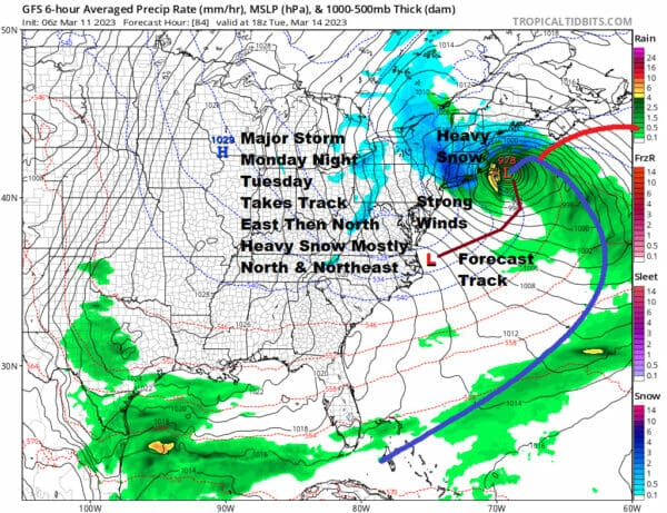
For now we will wait for a couple of more model cycles to see how newer data gets handled and digested. Right now it seems that areas south and west of NYC will see little or nothing snow wise and the best chances for anything significant would be north and northeast of NYC with 6 inch or more amounts more likely north of Route 84 and less likely southward to the coast. That would be my early opinion on this storm system. The risk time would be Monday night into Tuesday as rain develops late in the day Monday with a some light snow inland and then as the storm intensifies we see heavier snows break out to the north and northeast late Monday night into Tuesday. We will see strong winds develop Tuesday from the north and northwest with gusts probably in a range of 30 to 40 mph, that seems likely for most folks. We will start to zero in on specifics later today and for sure on Sunday.
BE SURE TO DOWNLOAD THE FREE METEOROLOGIST JOE CIOFFI WEATHER APP &
ANGRY BEN’S FREE WEATHER APP “THE ANGRY WEATHERMAN!
MANY THANKS TO TROPICAL TIDBITS & F5 WEATHER FOR THE USE OF MAPS
Please note that with regards to any severe weather, tropical storms, or hurricanes, should a storm be threatening, please consult your local National Weather Service office or your local government officials about what action you should be taking to protect life and property.