Winter Weather Advisories Inland Flood Watch For Heavy Rains Coast
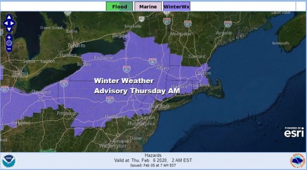
Winter Weather Advisories are posted for much of Pennsylvania except the southeast and southwest parts of the state, Northern New Jersey mainly north and west of the NJ Turnpike and west of 287, the Hudson Valley north of 287 and Connecticut north of I-95. Flood Watches are posted for heavy rains for coastal and Southern New Jersey southward. Winter Storm Watches and Warnings are posted for parts of upstate and Western NY as well as much of interior Northern New England.
SATELLITE
REGIONAL RADAR
We have been fighting clouds all day long today along with a colder dry flow from the north as high pressure and some marginal cold air drain southward which sets us up for freezing rain developing tonight in the advisory areas. Rain is developing on the regional radar across Virginia and points west and this area will gradually expand northward overnight. Look for freezing rain and rain to overspread Pennsylvania tonight and then spread to the rest of the advisory area during the early morning hours.
LOCAL RADAR NEW YORK CITY
LOCAL RADAR PHILADELPHIA

As far as ice accumulation is concerned it will be confined t the early morning hours until shortly after daybreak. It will last through the mid morning hours in the Hudson Valley and Connecticut. Most ice accumulations will be contained to under a tenth of an inch. Along the coast temperatures tonight will be in the mid to upper 30s but inland look for readings to drop to the upper 20s and lower 30s and then start to rise toward morning.
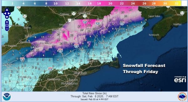
Snow lovers will have to head north from I-90 north and east as well as to the west and southwest. Skiers should be happy with the fresh snows of up to a foot possible in Northern NY and Northern New England with the snow coming in two parts. The first from the lead wave tonight into Thursday and the second from the developing storm Thursday night and Friday. Temperatures Thursday will rise into the 40s from NYC north but we could see 60s reach Southern New Jersey and Southeast Pennsylvania.
The main event for the coast from this will be rain and the bulk of this will come from the second wave that arrives late Thursday into Friday morning. This low will intensify into a major storm and will also be the main snow producer for the interior Northeast.
This storm is likely to produce widespread severe weather. We are seeing some of that tonight in the Central Gulf States and we will likely see a strong outbreak of thunderstorms Thursday from the Southern Mid Atlantic to the Southeast US and into the northern half of Florida.
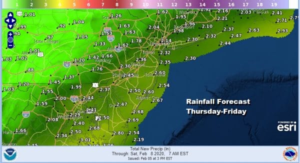
Rainfall amounts of 2 to 3 inches from NYC and Long Island southward are likely before this all comes to an end Friday morning. Don’t be surprised if we hear a few rumbles of thunder here Thursday night but it won’t be severe weather. Windy conditions will develop Friday as the low moves away to the northeast. Weather conditions should improve as the day wears on Friday with clouds and some developing afternoon sun but winds will gust to 30 to 40 mph at times. Temperatures on Friday will settle in the 30s. The weekend starts cold but dry Saturday with some sunshine. Highs will be in the 30s. Some clouds will be around Sunday with highs in the upper 30s and lower 40s. Then the next cold front arrives with a chance for showers on Monday.
BE SURE TO DOWNLOAD THE FREE METEOROLOGIST JOE CIOFFI WEATHER APP &
ANGRY BEN’S FREE WEATHER APP “THE ANGRY WEATHERMAN!
MANY THANKS TO TROPICAL TIDBITS FOR THE USE OF MAPS
Please note that with regards to any severe weather, tropical storms, or hurricanes, should a storm be threatening, please consult your local National Weather Service office or your local government officials about what action you should be taking to protect life and property.


