
Winter Storm Watch Southern Half of New Jersey, Southeast PA
Storm Will Pass South Monday

Winter Storm Watch Southern Half of New Jersey, Southeast PA
Storm Will Pass South Monday
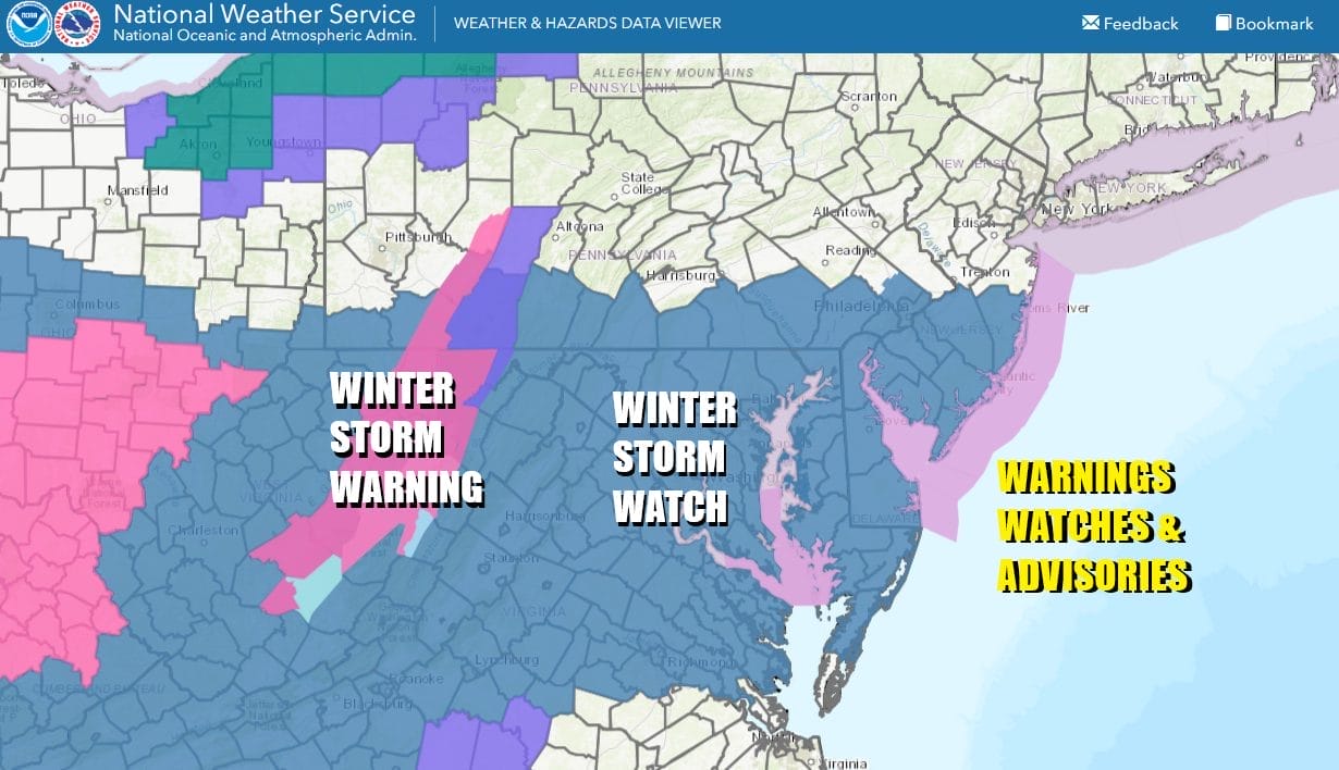
Winter Storm Watches are up for the southern half of New Jersey (mainly south of Route 195), Southeastern Pennsylvania and points south and southwest into Delaware Maryland and Virginia. North of this zone no watches or advisories are in effect at this time. There will be a sharp cut off of accumulating snow as you head to the north. Right now in New Jersey north of Route 80 and from NYC and Long Island northward, a dusting of snow or perhaps a few tenths of an inch are possible but it is also possible that these areas do not see a flake from this system
SATELLITE WITH LIGHTNING STRIKES

WEATHER RADAR

Meanwhile there are no weather issues today other than the fact that it is cold and it is still rather windy. We continue to see our weather dominated by a blocking storm over Newfoundland and it is not going away anytime soon. Today should be no worse than partly sunny across Eastern Pennsylvania to Southern New England. Temperatures this afternoon will likely top out mostly in the lower 30s.

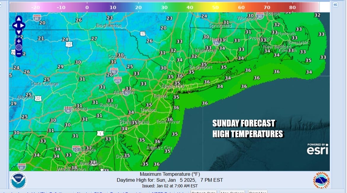
Most lows tonight will be in the teens to lower 20s under a clear sky and there still will be a bit of a wind keeping temperatures uniform. Sunday we see what should be mainly a sunny day though some high clouds could start to come in from the west ahead of the storm system. Sunday highs will be mostly in the lower 30s with a few places pushing it up to 35 or so.
Sunday night into Monday strong low pressure that will move across the Lower Ohio Valley Sunday night and will continue to push eastward toward Western Virginia Monday morning. Snow will spread from the Ohio Valley into West Virginia, Virginia Maryland and Delaware by Monday morning. The low then redevelops in Eastern North Carolina as the strong block to the northeast forces the center to jump to the coast.
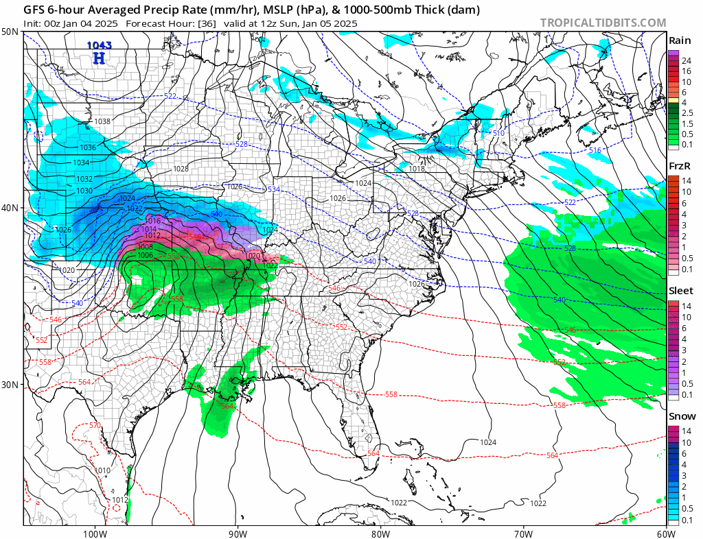
The issue with this storm is that the strong blocking low near Newfoundland does not allow the storm to move northward but rather it continues to slide to the east. Snow will only be able to get so far north before it sharply cuts off. We think that cut off will lie somewhere near Interstate 78 in New Jersey. Areas to the north will see a chance for a coating to at most an inch from south to north. North of Interstate 287 in New Jersey eastward across Long Island and Connecticut will see very little from this.

We start to see accumulating snow south of Interstate 195 in New Jersey and areas going south and southwest into Southeast and South Central Pennsylvania will get several inches or more but there is the danger of this system getting suppressed even further south which could lower amounts there. The block seems to be just to strong for a northward adjustment and while I will not rule it out, it seems rather unlikely at this point. We will see what the dayside guidance does with will this.
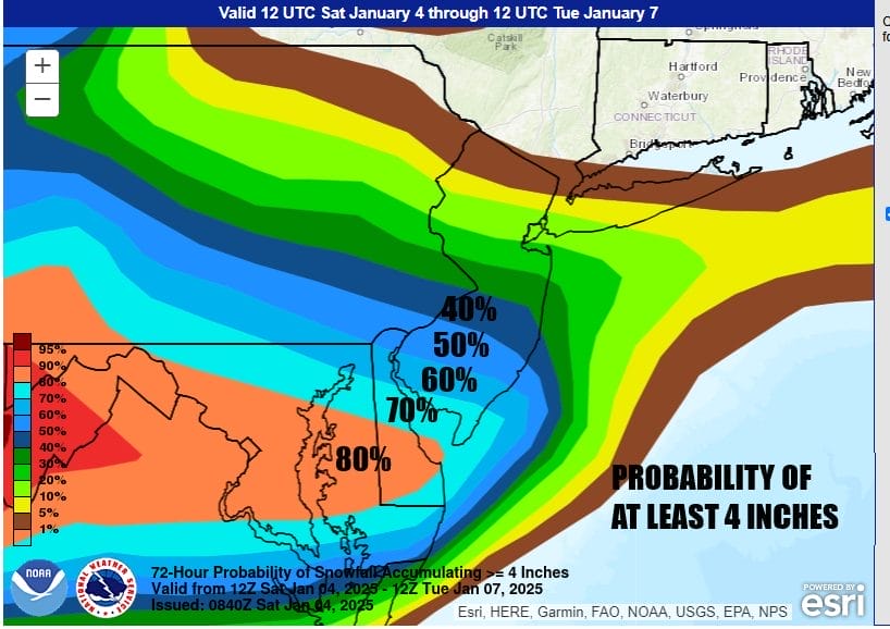
The Weather Prediction Center shows the highest probability of at least 4 inches for Southern New Jersey, Southeast Pennsylvania and points south. The highest probability of 80 percent or higher lies across Delaware in Maryland and Northern Virginia and this area includes Washington DC and Baltimore. Overall for Sunday night into Monday we will see snow arrive by daybreak in Southern New Jersey and Southeast Pennsylvania, then we watch to see how far north it gets. Cloudy skies will like further north across Northern New Jersey and Long Island. Where it is snowing hard enough tempertures will settle in the upper 20s to around 30 degrees while Monday highs where it snows very little if at all will be in the lower 30s. This all ends from west to east Monday night and improving but very cold conditions come in on the backside for Tuesday and for the remainder of the week.
BE SURE TO DOWNLOAD THE FREE METEOROLOGIST JOE CIOFFI WEATHER APP &
ANGRY BEN’S FREE WEATHER APP “THE ANGRY WEATHERMAN!
MANY THANKS TO TROPICAL TIDBITS FOR THE USE OF MAPS
Please note that with regards to any severe weather, tropical storms, or hurricanes, should a storm be threatening, please consult your local National Weather Service office or your local government officials about what action you should be taking to protect life and property.


