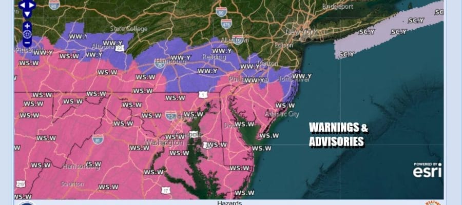
Winter Storm Warnings & Winter Weather Advisories Posted
for Parts of Eastern Pennsylvania & New Jersey

Winter Storm Warnings & Winter Weather Advisories Posted
for Parts of Eastern Pennsylvania & New Jersey
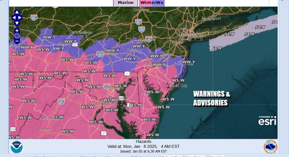
A powerful storm moving across the Lower Ohio Valley later today and tonight will push into the Middle Atlantic states Monday. We have Winter Storm Warnings for areas across Southern New Jersey and Southeastern Pennslyvania southward into Delaware, Maryland and Virginia while Winter Weather Advisories like on the northern boundary of the warnings in Central New Jersey near Interstate 195 & Interstate 78.
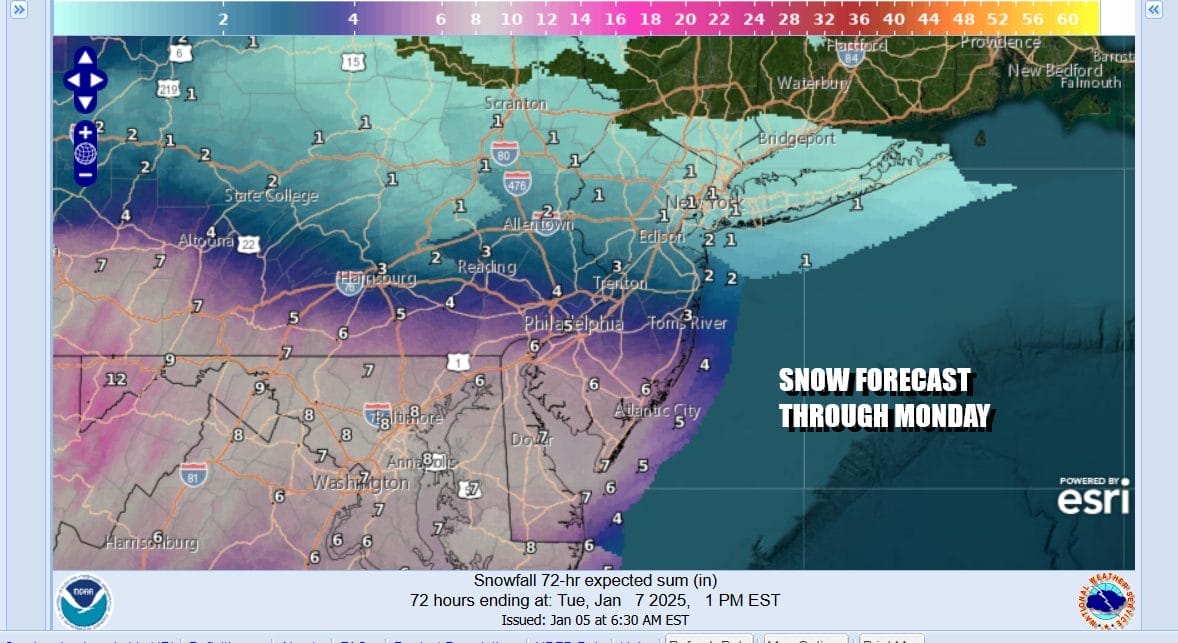
The period of concern is for tonight in the Washington DC/Baltimore area and then snow will spread northward into Southeastern Pennsylvania and Southern New Jersey overnight. During Monday morning the northern edge of the snow will possibly reach NYC and Long island but areas in Northern NJ north of Route 78 to Long Island and the lower Hudson Valley, a coating or a bit more is possible but the accumulating snows will be further south. We think anywhere from several to 6 inches will fall in Southern New Jersey and Southeast Pennsylvania and 6 inches plus further south into Maryland, Delaware and Virginia.
SATELLITE WITH LIGHTNING STRIKES

WEATHER RADAR

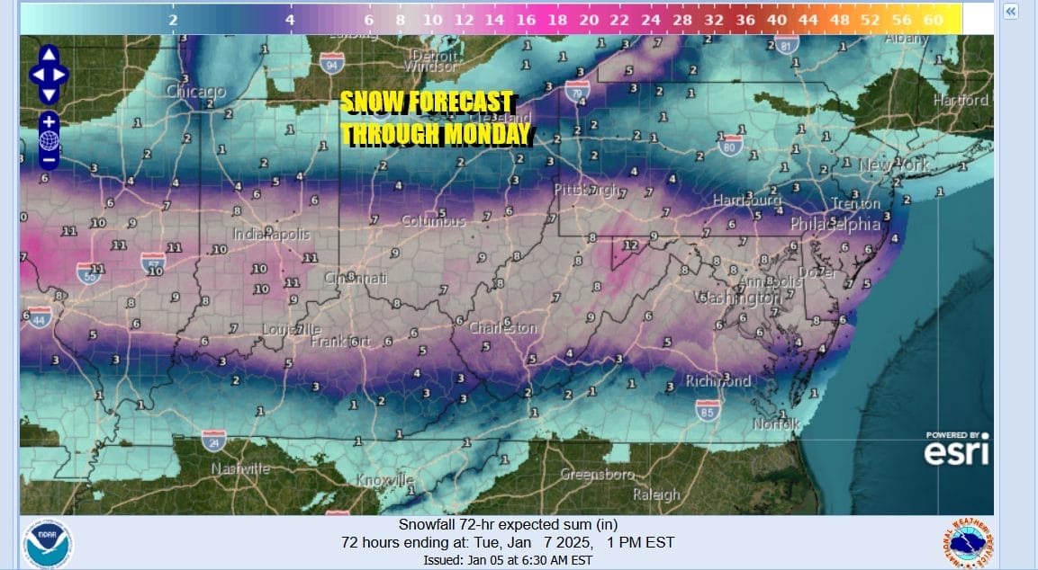
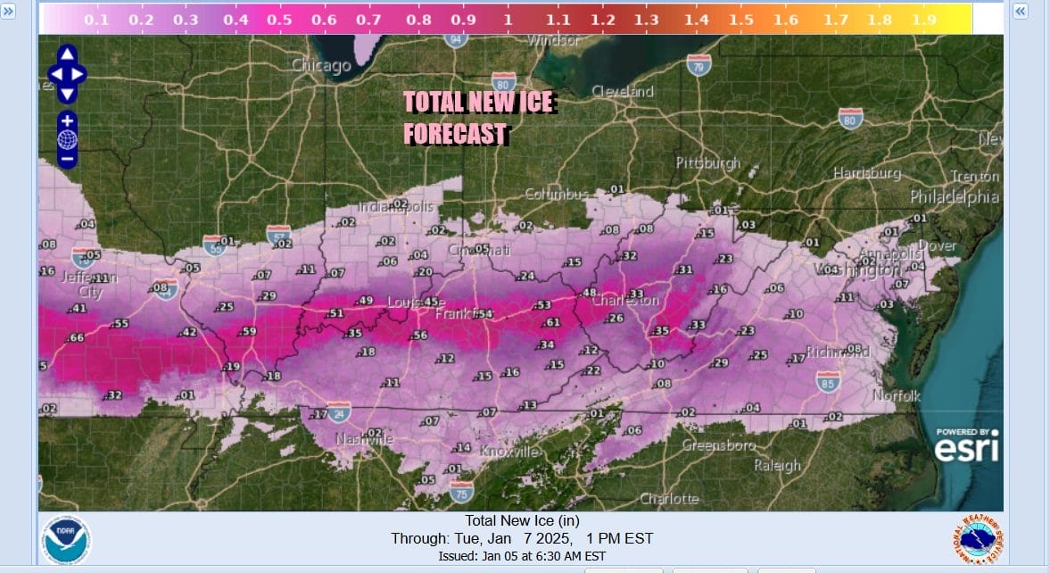
This storm is a bit unusual because the low pressure storm center is tracking almost straight eastward with little in the way of a northward component of motion. As a result there are sharp cutoffs of the heavy snow both to the north and to the south in a 1500 mile stretch. Areas along the track across Kansas, Missouri, Kentucky, Illinois, Indiana, Ohio, West Virginia and Virginia will see a wide area of 12 inches or more and also a heavy accumulation of ice in many areas.
Weather conditions today will be okay with sunshine giving way to arriving clouds across Eastern Pennsylvania to Southern New England. Most highs today will be in the low to middle 30s at best. Then clouds will thicken up tonight as we turn our attention to low pressure coming eastward from Kentucky and heading for Southern Virginia. This low is being forced eastward thanks to the strong blocking low to the northeast in the North Atlantic.

Monday sees the northern fringe of the snow reach areas in Northern New Jersey, New York City and Long Island. It won’t last long there as by afternoon the area of snow will begin to shift south and east. Heavier accumulating snow will continue in South Central, Southeast Pennsylvania, Southern New Jersey, and Delaware into the afternoon but here too it should start to come to an end from west to east. While it is snowing, temperatures will be in the 20s tonight and in the upper 20s to near or just over 30 Monday. By Tuesday we will see improving weather conditions with very cold temperatures by day. Highs Tuesday through Thursday will be just in the upper 20s and lower 30s. Nighttime lows will be in the teens in most locations and perhaps single digits in coldest spots mid and late week.
BE SURE TO DOWNLOAD THE FREE METEOROLOGIST JOE CIOFFI WEATHER APP &
ANGRY BEN’S FREE WEATHER APP “THE ANGRY WEATHERMAN!
MANY THANKS TO TROPICAL TIDBITS FOR THE USE OF MAPS
Please note that with regards to any severe weather, tropical storms, or hurricanes, should a storm be threatening, please consult your local National Weather Service office or your local government officials about what action you should be taking to protect life and property.


