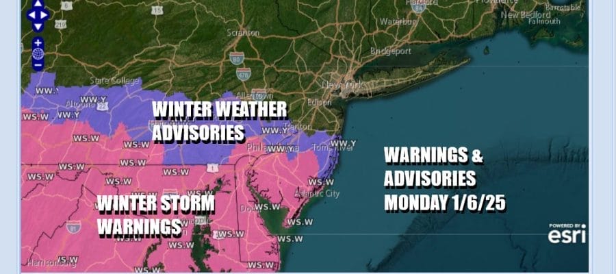
Winter Storm Warning South Jersey Southeast Pennsylvania
Very Little Snow Northern New Jersey to Long Island

Winter Storm Warning South Jersey Southeast Pennsylvania
Very Little Snow Northern New Jersey to Long Island
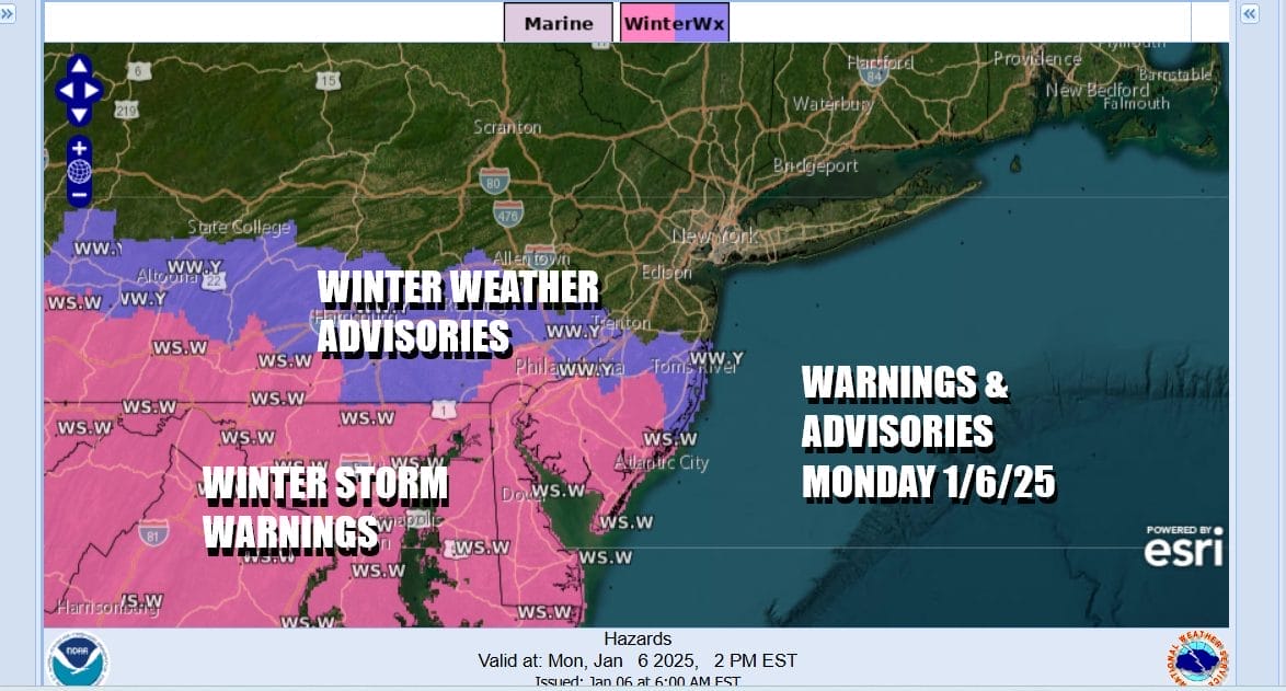
The major storm from the Plains has now reached the Mid Atlantic and we have seen snow overnight spread across Virginia, Maryland and Delaware. Now comes the final push northward into early afternoon before dry air comes down from New England and basically disintegrates the snows off the radars. Winter Weather Advisories covers Eastern Pennsylvania to New Jersey south of Route 195. Extreme Southeast Pennsylvania, Southernmost New Jersey, Delaware, Maryland and Virginia are all under Winter Storm Warnings.

As far as snow accumulations are concerned, areas outside of any advisories are warnings will likely see a coating to at most an inch while in advisories areas look for 2 to 4 inches and Winter Storm Warning areas will see 4 to 6 inches or higher. Parts of Northern Virginia and Maryland could finish up with 10 inches or more. We can see the precipitation on the radar loops generally moving west to east and the northern fringe is struggling to move north of NYC and Northern New Jersey.
SATELLITE WITH LIGHTNING STRIKES

WEATHER RADAR

The surface low in West Virginia will pop up off the Virginia Capes around midday and once this happens, winds will turn more northerly and gradually increase later this afternoon and evening. Dry air will filter in from New England and you will see on the HRRR model loop how the snow area basically falls apart after 1 or 2pm this afternoon.

Temperatures today will be in the 20s in areas where it is snowing hard enough. Otherwise most other areas where snow is light or non existent, highs will be in the lower 30s under cloudy skies. Tonight will be windy as skies partially clear. Lows will be in the teens to around 20. Tuesday will be windy and cold with some sunshine. Highs will reach the upper 20s and lower 30s.
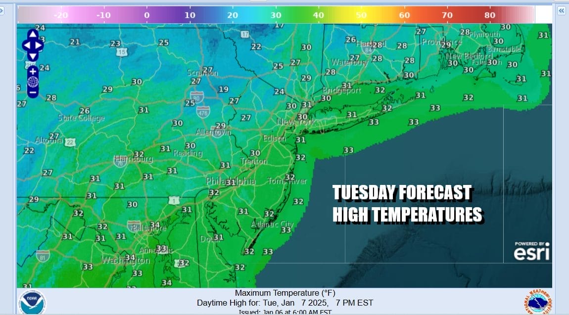
Tuesday night will be cold clear and windy at times. Lows will be in the mid to upper teens inland and lower 20s coast and warmer urban areas. Wednesday will be another partly to mostly sunny, windy and cold day. High temperatuers will be in the upper 20s and lower 30s. Strong gusty winds will be a feature all week long thanks to a strong blocking storm sitting in Atlantic Canada and it shows no signs of giving way through at least Thursday.

Late this week a new storm will develop in the Gulf of Mexico and that storm will bring snow sleet and freezing rain to some areas in the Deep South from Northern Mississippi to North Georgia into the Carolinas. The block to the northeast in Atlantic Canada will be a big player here in determining what happens to this storm longer term. If the block is too strong ( and it very well could be) it will bring snows to the Carolinas and Virginia before the storm slides out to the east and offshore. A further north track would require the block to shift to the east. We will be monitoring develops in the models over the next several days to see which way this goes.
BE SURE TO DOWNLOAD THE FREE METEOROLOGIST JOE CIOFFI WEATHER APP &
ANGRY BEN’S FREE WEATHER APP “THE ANGRY WEATHERMAN!
MANY THANKS TO TROPICAL TIDBITS FOR THE USE OF MAPS
Please note that with regards to any severe weather, tropical storms, or hurricanes, should a storm be threatening, please consult your local National Weather Service office or your local government officials about what action you should be taking to protect life and property.


