Risks Rise Widespread Snow & Ice Deep South & Southeast US Late Week,
Eastern US Could Follow Over The Weekend

Risks rise widespread snow & ice across the Deep South & Southeast late week, Eastern US follows
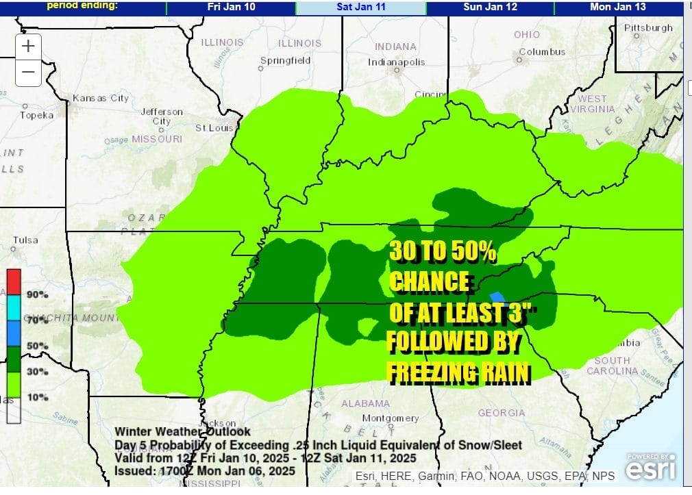
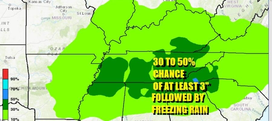
Risks of a snow and ice storm are rising across the Deep South for late this week. The Weather Prediction Center of the National Weather Service is indicating a 30 to 50 percent chance for at least 2 to 3 inches of snow followed by what could be along period of freezing rain and ice accretion. The risk area includes Northern Mississippi, Northern Alabama, Northern Georgia, virtually all of Tennesse Western South Carolina and Western North Carolina, A storm developing in the Gulf of Mexico will move east, hugging the Gulf Coast from Texas to the Florida Panhandle.

Photo byTROPICAL TIDBITS
,A cold dome of high pressure is forecast to settle over the Mid Atlantic states and wedge southwestward into the Appalachians. This is a set up fo a long duration freezing rain event which will be especially troublesome for much of Norhtern Georgia, South Carolina an North Carolina.
Photo by Pivotal Weather
As far as the snow is concerned, model guidance brings several inches of snow or more over the entire risk area during Friday. Highest snow amounts will be across Arkansas, Northern Mississippi into Tennessee. Model guidance suggest widespread 3 to 6 inches of snow before it ends as some freezing rain later Friday
Photo by Pivotal Weather
In North Georgia and into Western South Carolina, after a snowfall of up to several inches, temperatures rise aloft, changing the snow over to sleet and then freezing rain. Ice accretion forecast from various models show a half inch to an inch of ice accretion especially in the areas near the mountains of North Georgia and both South Carolina and North Carolina.
Photo by Pivotal Weather
The freezing rain could last well into Friday night or early Saturday morning before the storm system heads out to the northeast. It could eventually bring heavy snow, sleet, freezing rain and rain to the Middle Atlantic and Northeast over the weekend. We will be monitoring this storm very carefully in the coming days.
BE SURE TO DOWNLOAD THE FREE METEOROLOGIST JOE CIOFFI WEATHER APP &
ANGRY BEN’S FREE WEATHER APP “THE ANGRY WEATHERMAN!
MANY THANKS TO TROPICAL TIDBITS FOR THE USE OF MAPS
Please note that with regards to any severe weather, tropical storms, or hurricanes, should a storm be threatening, please consult your local National Weather Service office or your local government officials about what action you should be taking to protect life and property.