
Winter Storm Watch Late Monday Night into Tuesday Afternoon Central Pa, Northern NJ, Hudson Valley fo Southern New England

Winter Storm Watch Late Monday Night into Tuesday Afternoon Central Pa, Northern NJ, Hudson Valley fo Southern New England
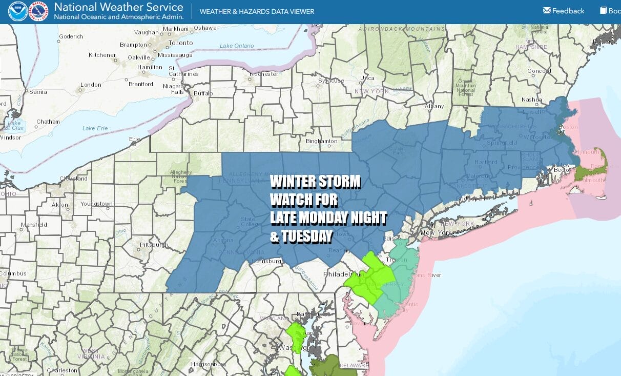
Winter Storm Awatches are posted from Central Pennsylania to Northern New Jersey, the Hudson Valley, the Catskills, east to Connecticut, Rhode Island, and much of Massachusetts. The immediate coast is not under any watches or advisories at this time. This is for late Monday night into Tuesday afternoon. Before we get there we what should be a dry day though we have clouds to deal with. Radar is showing rain across Virginia, Maryland and Delaware and the northern edge of that rain will possibly touch Southern New Jersey.

Otherwise we will see clouds. North of NYC clouds will thin out somewhat while to the south there will be a heavier overcast. Temperatures today will be topping out in the upper 40s and lower 50s. Rain will slide out to the east and south and skies should partially clear out tonight. Monday morning lows will be in the 30s.
SATELLITE WITH LIGHTNING STRIKES

WEATHER RADAR

Monday will be day of sunshine giving way to arriving clouds with highs in the upper 40s and lower 50s. Then our attention turns to a storm, which today is moving east across the Deep South with showery heavy rains and some severe weather for the Gulf coast and eventually to the Southeast US. The low will move into the Central Appalachiains and then exit offhsore the Delaware coast late Monday night into Tuesday morning.

The low tracks east northeastward south of Long Island and Southeastern New England. Like storms back in January, just enough warm air around will keep accumulations along the immediate coast of Southern New England, Long Island and coastal New Jersey to a minimum, inland areas north and northwest of NYC and Philadelphia will see accumulating snow as will much of Connecticut and Rhode Island north of I-95.
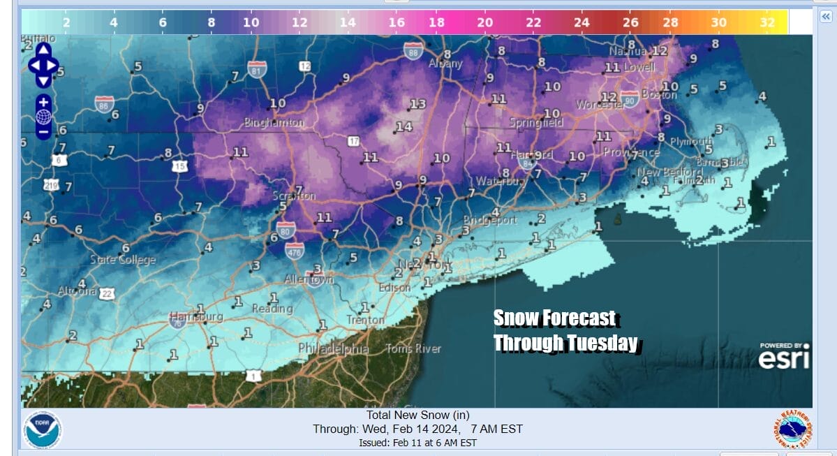
One foot plus snows are possible from Northeast Pennsylvania eastward across NY State north of Route 84 and into Northern Connecticut to Massachusetts. The Weather Prediction Center has this area at a 50 percent or higher probability for at least 8 inches of snow accumulation.

For the big cities like Philadelphia and NYC and Long Island as well as Coastal New Jersey, at most a coating to an inch or 2 is possible from this system. Snow and rain develop Monday night into early Tuesday morning and most areas inland will change to heavy snow while at the coast it will be rain that might go to snow for awhile. All of this comes to an end from west to east Tuesday afternoon. Temperatures will be mostly in the low to mid 30s. Weather conditions will improve Tuesday night and Wednesday and Thursday will be chilly days with sunshine. Highs both days will be mostly in the 30s.
BE SURE TO DOWNLOAD THE FREE METEOROLOGIST JOE CIOFFI WEATHER APP &
ANGRY BEN’S FREE WEATHER APP “THE ANGRY WEATHERMAN!
MANY THANKS TO TROPICAL TIDBITS FOR THE USE OF MAPS
Please note that with regards to any severe weather, tropical storms, or hurricanes, should a storm be threatening, please consult your local National Weather Service office or your local government officials about what action you should be taking to protect life and property.
(Amazon is an affilate of Meteorologist Joe Cioffi & earns commissions on sales.)


