Winter Storm Warnings Inland, Winter Storm Watch NYC & Long Island,
Snow Amounts Raised

Winter Storm Warnings Inland, Winter Storm Watch NYC & Long Island,
Snow Amounts Raised
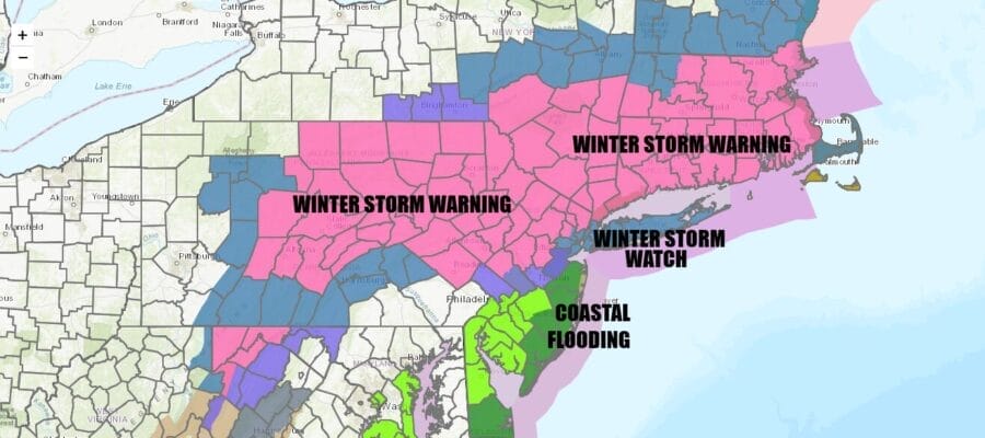
Winter Storm Warnings are up from Central Pennsylvania to Northern New Jersey to the Hudson Valley and the Catskils, eastward to all of Southern and Central New England. Warnings have been extended further south into New Jersey and we have Winter Storm Watches up now from just northeast of Philadelphia east across and north of Route 195. Winter Storm Watches are also no up for areas around NYC and Long Island. I expect that these areas will go to a warning later today or tonight.
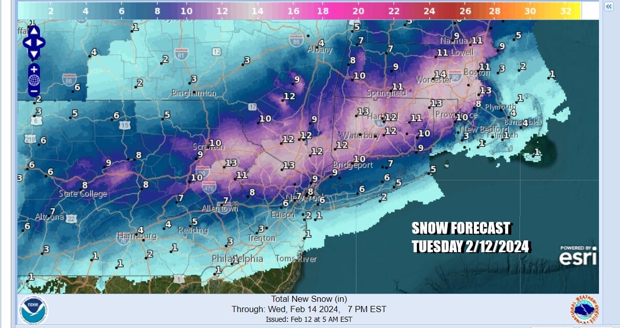
Snow amounts forecast from the National Weather Service have been raised across the board with 4 to 6 inches now forecast for NYC and Long Island and 8 to 12 inches inland from Northeast Pennsylvania and Northern New New Jersey and across much of Southern and Southeastern New England. We have no weather issues to worry about today across the Northeast and Mid Atlantic with increasing clouds from south to north and high temperatures mostly in the 40s to around 50 degrees.
SATELLITE WITH LIGHTNING STRIKES

WEATHER RADAR

Low pressure today is moving across the South and we are seeing heavy rain and widespread severe weather forecast from the Gulf States to the Southeast US. Tornado risk is elevated in this areas as well as the potential for 2 to 4 inches of rain. It is clear from satellite and radar loops that a major storm is starting to develop as it heads up the Appalachians and then redevelops in eastern Virginia overnight, tracking offshore Tuesday morning.

There isn’t much cold air ahead of this storm system and a limited amount of cold air behind the low. This has been about strong upper air dynamics all along, playing out where the atmosphere cools from the top down. This sets up for a heavy wet snowfall from Eastern Pennsylvania to Southern New England. Most areas will see precipitation develop overnight as the atmosphere cools aloft rather rapidly. Snow or rain develops in the early morning hours and then quickly changes over to snow before daybreak. Intensity will drive snow accumulations and we could see snow rates of 1 to 2 inches an hour develop. The storm moves along and snow comes to an end from west to east from early to mid afternoon. Coastal and Southern New Jersey will see mostly rain changing to snow before ending. Coastal flooding will be an issue tonight into Tuesday morning until winds turn to the north. Temperatures Tuesday will be plus or minus a degree or two of freezing while snow is falling. Weather conditions will improve Tuesday night and Wednesday will be a sunny chilly day with most highs in the 30s to around 40 degrees.
BE SURE TO DOWNLOAD THE FREE METEOROLOGIST JOE CIOFFI WEATHER APP &
ANGRY BEN’S FREE WEATHER APP “THE ANGRY WEATHERMAN!
MANY THANKS TO TROPICAL TIDBITS FOR THE USE OF MAPS
Please note that with regards to any severe weather, tropical storms, or hurricanes, should a storm be threatening, please consult your local National Weather Service office or your local government officials about what action you should be taking to protect life and property.
(Amazon is an affilate of Meteorologist Joe Cioffi & earns commissions on sales.)


