Winter Storm Watch Inland Snow Sunday, Mix Along The Coast
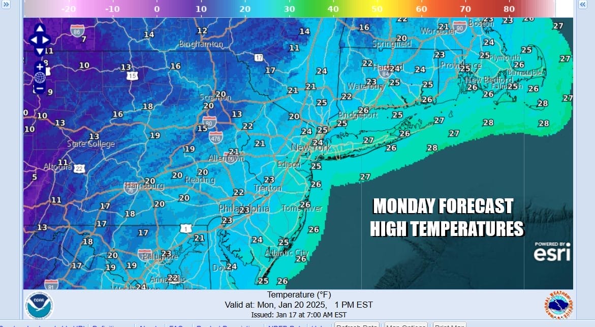
Arctic Air Arrives Monday

Winter Storm Watch Inland Snow Sunday, Mix Along The Coast
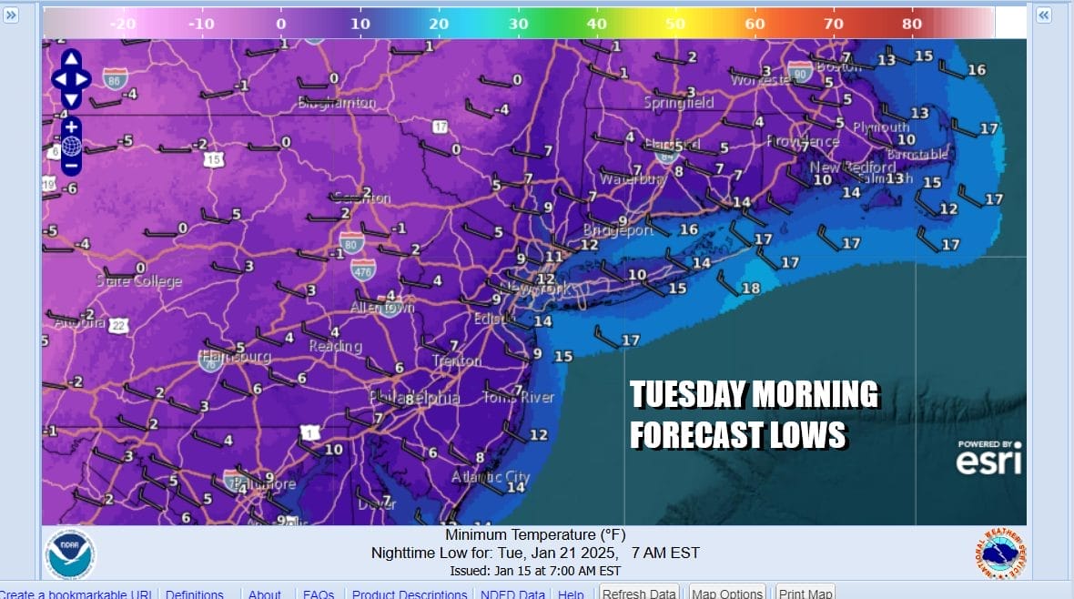
Arctic Air Arrives Monday
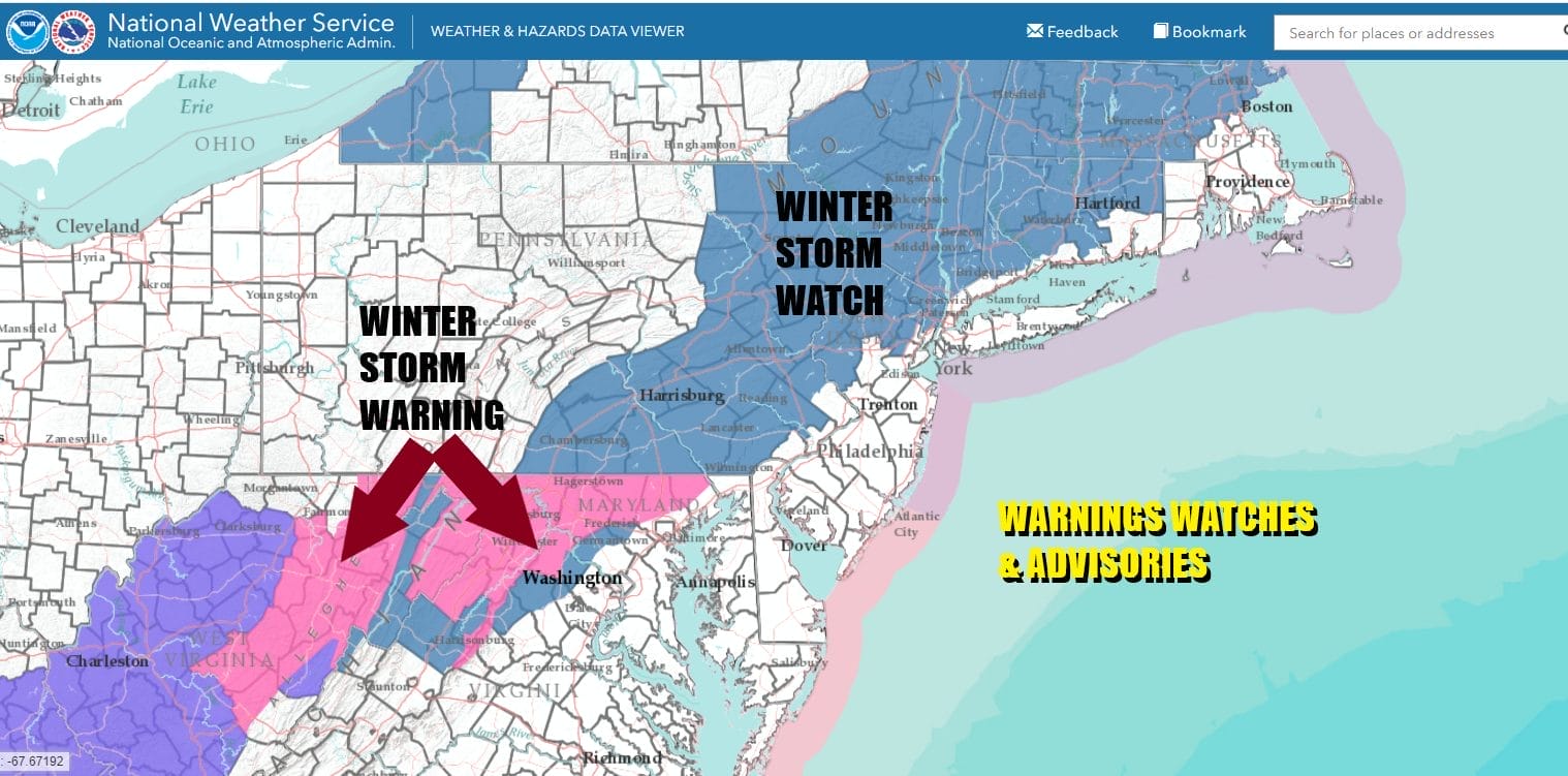
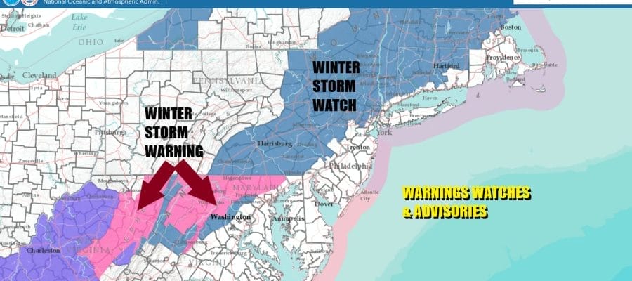
This is a very difficult forecast indeed given the uncertainty surrounding the track of a developing low just offshore. Winter Storm Watches and warnings extend from West Virginia to New England. The immediate coast may have some rain issues at the start but even that is not a certainty either. For now most forecasts for snow haven’t changed much since yesterday and it is likely to be some adjustments later today.
For now we are seeing forecasts of 4 inches or more just inland of the immediate coast with lesser amounts as you head south in coastal New Jersey and Eastern Long Island. However these amounts could change later today as we get a better grasp of how much cold air and how fast it moves in during Sunday. In the meantime today we have some showers of rain to contend with ahead of a cold front.
SATELLITE WITH LIGHTNING STRIKES

WEATHER RADAR

We can see those showers to the west and south on the radar moving northeast. Most of the rain with this weather front is on the light side and we will see showers this afternoon as the front passes from west to east. Temperatures today will be on the mild side with highs mostly in the low to middle 40s.

Once the front passes through it will move well offshore but the southern part of the front stalls temporarily across the Southeastern US as it waits for a wave to develop there tonight and then move northeastward up the coast Sunday. Very cold arctic air lies just to the west and as the low moves northeast just offshore, colder air will begin to sweep southeastward Sunday, right at the time that precipitation is arriving.

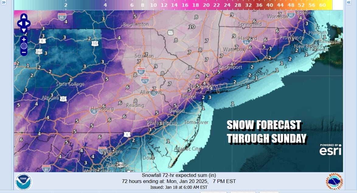
The tricky part is figuring out the timing of the storm system and the cold air. Weather models are all different with regards to the outcome which is why forecasting snow amounts is a challenge this time around. The system does move quickly so that will limit any upside on amounts. Snow will develop and reach southernmost Pennsylvania around 7am Sunday and the reach NYC and nearby areas around 1pm, and between 1 and 3 pm across Southern New England and Long Island. Along the immediate coast there will be some rain at the start and then as colder air takes over, it will change over to snow later in the afternoon or early evening.
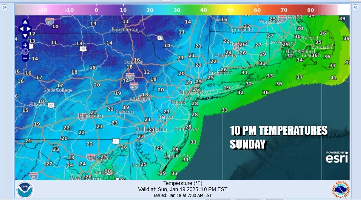
Most temperatures Sunday will top out in the low to middle 30s but once snow starts inland temps will drop into the 20s and then the 20s will reach the coast sometime during the evening hours. Snow will taper off from southwest to northeast Sunday evening and skies should clear with a gusty wind and lows by Monday morning will be in the teens to near 20.
Mainly clear skies and bitter cold air will settle in Monday night and Tuesday morning it will be brutally cold. Lows will bottom in the single digits with some zero readings or less inland especially due to the newly acquired snow cover. Warmer urban areas will have a tough time holding on to the 10 degree mark at daybreak. Tuesday dayside will be a day of ineffective sunshine and highs not getting out of the teens.
Arctic air will be covering much of the US and it will extend down to the Gulf Coast where a developing low in the Western Gulf of Mexico will spread snow and ice from Texas to Georgia Tuesday and Tuesday night. While the main low will then shift to the Southeast Coast and spread snow and ice to the Carolinas (including the coast), Clouds will move northward Tuesday night and we might even see a little snow from this system in coastal areas of New Jersey and Long Island Wednesday, though if we do it won’t amount to much.

This storm system early next week will bring snow and ice to cities that see snow maybe once every 10 years or so. Cities like Houston, New Orleans, Montgomery, Atlanta, Charleston, & Wilmington North Carolina could see significant snow from this storm system along with bitter cold air that will cover all of the Deep South and Southeastern US. Winter certainly will have a firm grip across much of the US over the next 7 days.
BE SURE TO DOWNLOAD THE FREE METEOROLOGIST JOE CIOFFI WEATHER APP &
ANGRY BEN’S FREE WEATHER APP “THE ANGRY WEATHERMAN!
MANY THANKS TO TROPICAL TIDBITS FOR THE USE OF MAPS
Please note that with regards to any severe weather, tropical storms, or hurricanes, should a storm be threatening, please consult your local National Weather Service office or your local government officials about what action you should be taking to protect life and property.


