A Few Showers Saturday Snow Later Sunday Into Early Monday Morning
Bitter Cold Air Arrives

A Few Showers Saturday Snow Later Sunday Into Early Monday Morning
Bitter Cold Air Arrives
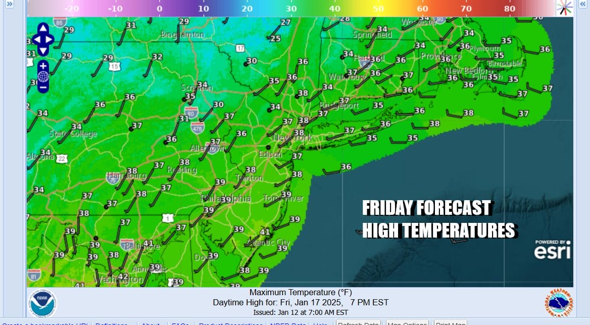
Today is a bounce day as far as temperatures are concerned. An upper trough and warm front have moved to the east. We will see partly sunny skies today and temperatures are going to go above freezing and top in the upper 30s and lower 40s this afternoon. This is all ahead of the next cold front that will bring clouds tonight and the chance for some showers Saturday. Most lows tonight will be in the mid 20s to around 30.
SATELLITE WITH LIGHTNING STRIKES

WEATHER RADAR

Saturday we see the arrival of a cold front that will be pushing eastward across the Appalachians and the Northeast. There is isn’t much moisture with this front so we are looking perhaps for a few showers Saturday afternoon as the front passes. We will probably see a tenth of an inch or less and some places might just spend the whole day cloudy and miss out on showers entirely. Temperatures Saturday will be topping out in the low to middle 40s.

The front stalls out offshore and in the Southeast US, and arctic air awaits across the Midwest, Plains, and Ohio Valley. This is very large Arctic airmass spreading bitter cold air for everyone east of the Rockies. Along the frontal frontal boundary low pressure develops Saturday night and runs up fast up the East Coast just offshore. Snow will develop across West Virginia and Northern Virginia Sunday morning and spread into New England Sunday afternoon.
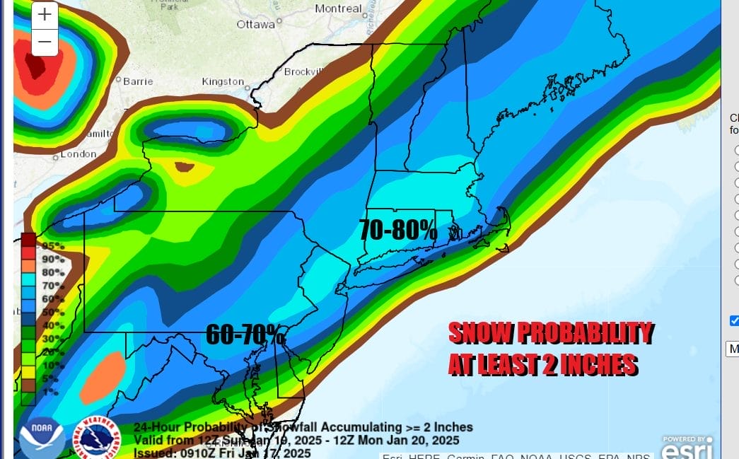
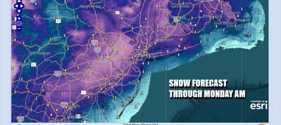
We have some early probability and snow forecasts from the Weather Prediction Center. Above we have the probability for at least 2 inches and it seems that much of the area from Eastern Pennsylvania to Southern New England is locked for at least a 2 to 4 inch snowfall. The first forecast map from local National Weather Service offices are showing a range of 4 inches near the coast with higher amounts inland.
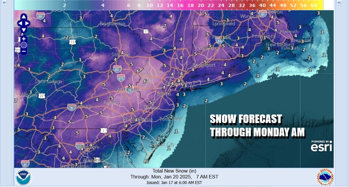
We are likely to be adjusting the amounts between now and Sunday once we have a solid idea of what the track of the low will be. If it is just offshore we could see some rain in the mix early along the immediate coast which might impact amounts in those areas (Eastern Long island, Coastal New Jersey). Inland areas including the big cities from Washington DC, Baltimore, Philadelphia, New York City, Hartford, and Boston look to be in line for at least 4 inches. Temperatures Sunday will be in the 30s and once the snow begins, temperatures will drop below freezing and into the 20s. Snow comes to an end Sunday night from west to east as the low pulls away. Monday morning lows will be in the teens to near 20. Monday will be very cold with temperatures hovering in the lower 20s all day and then the bottom falls out Monday night.
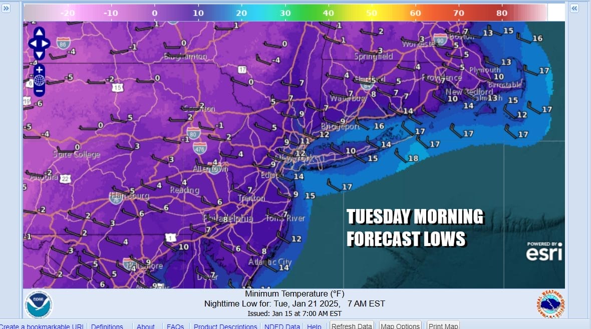
By Tuesday morning, lows will be in the single digits just about everywhere and areas inland especially where there is a snow cover will see temperatures bottom below zero. Tuesday highs will be in the teens with ineffective sunshine and then we go back down Tuesday night into Wednesday morning with lows in the teens to single digits. We may be watching another storm midweek as low pressure moves across the Gulf States and then heads northeast offshore. It appears for now that any snow from this will pass to the south but it could be a closer call if the low can climb up the Eastern Seaboard. This storm is likely to bring another round of snow and ice to the Deep South and Southeast US at the very least.
BE SURE TO DOWNLOAD THE FREE METEOROLOGIST JOE CIOFFI WEATHER APP &
ANGRY BEN’S FREE WEATHER APP “THE ANGRY WEATHERMAN!
MANY THANKS TO TROPICAL TIDBITS FOR THE USE OF MAPS
Please note that with regards to any severe weather, tropical storms, or hurricanes, should a storm be threatening, please consult your local National Weather Service office or your local government officials about what action you should be taking to protect life and property.


