
Winter Storm Warning Upstate NY New England 12122017

GET JOE A CIGAR SO HE CAN RELAX!
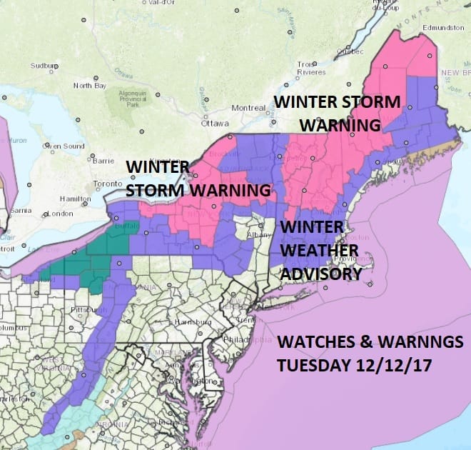
Winter Storm Warnings Upstate NY New England 12122017
We begin the day with a large part of Upstate NY & New England under a Winter Storm Warning as low pressure moves across upstate New York and across Central New England. Areas under a Winter Storm Warning could see anywhere from 6 to 12 inches of snow. Winter Weather Advisories are in effect for the southern flank of this area which extends southward to just north of Route 84. This system will bring a cold front through our area later this morning with a few showers followed by gusty winds and falling temperatures. Cold air moves in tonight and with the arrival of the cold air there could be a burst of snow in some places. The lake effect snow machine will be turned on again in Upstate NY & Western Pennsylvania as the strong flow off the Great Lakes creates the usual array of snow showers and snow squalls. The National Weather Service snow forecast maps are below.
NEW YORK CITY AND VICINITY SNOW

NEW YORK CITY & VICINITY ICE

NEW JERSEY & PARTS OF NE PA

SOUTHERN AND SOUTHEAST NEW ENGLAND

NORTHERN NEW ENGLAND

WESTERN NEW ENGLAND

MIDDLE AND UPPER HUDSON VALLEY

CENTRAL NEW YORK & NE PA

WESTERN NEW YORK

CENTRAL & SOUTH CENTRAL PA

VIRGINIA & MARYLAND

DAILY NORTHEAST SNOWFALL

Please be advised that these are National Weather Service Forecast Maps and they auto update. Each office may update at different times and some offices are slower to update then others. Maps are usually updated before 5am and & 5pm however they may be updated at other times depending on forecast conditions. These are not my forecasts. My forecasts can be found on the JOE’S SNOWFORECAST PAGE. Individual forecasts for specific areas may also be found when conditions warrant on the my area forecasts. Those can be found on the website menu. Click on forecasts and then select your specific area.