Winter Storm Warning New Jersey Shore Eastern Long Island
Winter Storm Warning New Jersey Shore Eastern Long Island
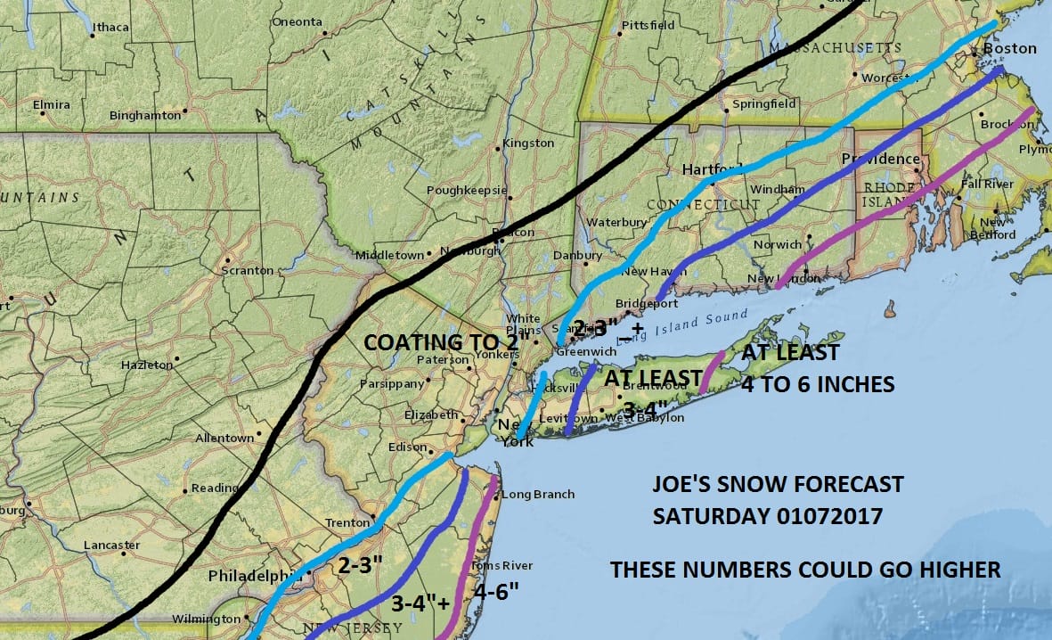
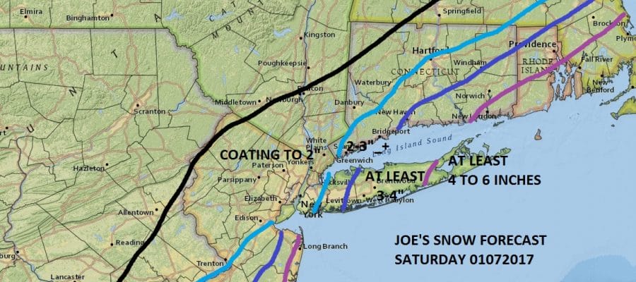
My latest snow forecast map for Saturday is above. The greatest risk for heavy snow lies along the New Jersey shore and for Eastern Long Island but be advised that this could still shift a little in either direction. Snow begins during the morning hours from south to north on Saturday with snow heavy at times into Saturday evening. The heaviest snow will be from Coastal Monmouth and Ocean Counties and for the Eastern Half of Long Island as well as for the Southeastern half of Connecticut. Amounts drop off sharply as you head north and west from New York City to a coating to 2 inches. Weather models continue to be on a westward trend so we will watch for any further model shifts tonight.
NEW YORK CITY AND VICINITY SNOW

NEW YORK CITY & VICINITY ICE

NEW JERSEY & PARTS OF NE PA

SOUTHERN AND SOUTHEAST NEW ENGLAND

NORTHERN NEW ENGLAND

WESTERN NEW ENGLAND

MIDDLE AND UPPER HUDSON VALLEY

CENTRAL NEW YORK & NE PA

WESTERN NEW YORK

CENTRAL & SOUTH CENTRAL PA

VIRGINIA & MARYLAND

DAILY NORTHEAST SNOWFALL

Please be advised that these are National Weather Service Forecast Maps and they auto update. Each office may update at different times and some offices are slower to update then others. Maps are usually updated before 5am and & 5pm however they may be updated at other times depending on forecast conditions. These are not my forecasts. My forecasts can be found on the JOE’S SNOWFORECAST PAGE. Individual forecasts for specific areas may also be found when conditions warrant on the my area forecasts. Those can be found on the website menu. Click on forecasts and then select your specific area.
SNOW REMOVAL COMPANIES FOR YOUR WINTER NEEDS
LONG ISLAND ROCKLAND COUNTY Connecticut

![]()

ROCKLAND COUNTY TRI STATE SNOW REMOVAL JOHNSTOWN PA