
Winter 2016-2017 Pennsylvania Colder, Snowier
Winter 2016-2017 Pennsylvania Colder, Snowier
Winter 2016-2017 Pennsylvania Snowfall Forecast
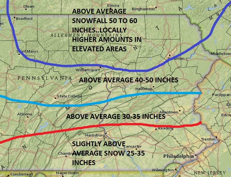
Last winter was a non winter for much of the northern half of Pennsylvania. The Blizzard of 2016 pretty much was all the snowfall that occurred for South Central and Southeastern Pennsylvania. I think we are going to see things go back to normal in terms of Winter 2016-2017 with colder than average temperatures on the order of 2 to 3 degrees or so. We will also see a more normal distribution of snowfall where the northern areas get more than the south which is usually how it works. Im leaning toward slightly above average for most areas. One of the things that makes forecasting snowfall more difficult is that at least for Southeastern Pennsylvania, you have to have the combination of cold air and precipitation lining up together. Northern areas have an easier time getting those combinations to occur. Also in terms of total precipitation is the drought pattern that may have a bigger impact in southern areas of the state than in the north. If the large scale dry pattern were to reverse than I think we could reach the high end of these numbers. However I want to see signs of that pattern easing and right now we don’t see any.

The pattern across much of the United States is about about as storm free as you will ever see it. The entire nation from coast to coast is under an upper high with deep troughs off each coast. As long as this condition exists storms will be kept away from both coastlines. Cold air is sealed up in Siberia and Europe. This type of setup is one that doesn’t support anything major. Even the minor systems will be even more minor than usual. For more on the short range pattern here is the latest video analysis
MANY THANKS TO TROPICAL TIDBITS FOR THE WONDERFUL USE OF THE MAPS
SNOW REMOVAL COMPANIES FOR YOUR WINTER NEEDS
LONG ISLAND ROCKLAND COUNTY Connecticut

![]()


WINTER 2016-2017 PART 1 OCEAN WATER TEMPERATURES
WINTER 2016-2017 PART 2 ARCTIC SEA ICE AND SIBERIAN SNOW COVER
FiOS1 News Weather Forecast For Long Island
FiOS1 News Weather Forecast For New Jersey
FiOS1 News Weather Forecast For Hudson Valley
NATIONAL WEATHER SERVICE SNOW FORECASTS
LATEST JOESTRADAMUS ON THE LONG RANGE
Weather App

Don’t be without Meteorologist Joe Cioffi’s weather app. It is really a meteorologist app because you get my forecasts and my analysis and not some automated computer generated forecast based on the GFS model. This is why your app forecast changes every 6 hours. It is model driven with no human input at all. It gives you an icon, a temperature and no insight whatsoever.
It is a complete weather app to suit your forecast needs. All the weather information you need is right on your phone. Android or I-phone, use it to keep track of all the latest weather information and forecasts. This weather app is also free of advertising so you don’t have to worry about security issues with your device. An accurate forecast and no worries that your device is being compromised.
Use it in conjunction with my website and my facebook and twitter and you have complete weather coverage of all the latest weather and the long range outlook. The website has been redone and upgraded. Its easy to use and everything is archived so you can see how well Joe does or doesn’t do when it comes to forecasts and outlooks.
Just click on the google play button or the apple store button on the sidebar for my app which is on My Weather Concierge. Download the app for free. Subscribe to my forecasts on an ad free environment for just 99 cents a month.
Get my forecasts in the palm of your hand for less than the cost of a cup of Joe!
![]()
