
COLD FRONT TONIGHT BRINGS SOME SHOWERS
WINDY CHILLY CONDITIONS SUNDAY TEMPS 40S WINDS GUSTING TO 30 MPH+
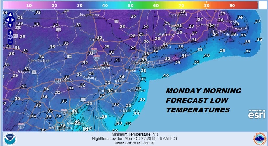
VERY COLD SUNDAY NIGHT INTO MONDAY MORNING
We did manage to break some sunshine through the clouds this afternoon and temperatures did at least get back into the lower 60s though they didn’t seem to have much push to get beyond those levels. The cold front with the next push of cold air will be moving through. The cold air will be pulled in by a developing wave on that front as it moves through tonight. This will produce a few showers. There could be a few scattered around this evening and then a few more showers are possible during the early morning hours. After that look for the wind to pick up quickly Sunday morning.
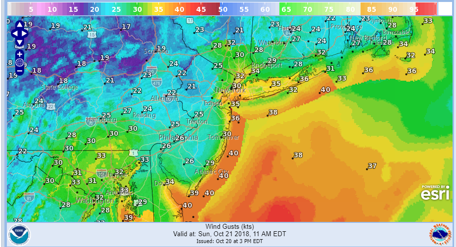
Winds will be gusty all day and they should reach 30 mph or more in gusts by mid morning Sunday lasting into at least mid afternoon. Some gusts to 40 mph are possible along the coast where gale warnings are posted. Temperatures will be in the 40s to near 50 so add the wind and it will feel like an early December day. Then winds will drop off sharply Sunday night under clear skies. Monday morning temps will be in the upper 20s to mid 30s with a variety of frosts and freezes depending on location.
There is no change in the outlook for the week ahead as we will see sunshine Monday with highs back in the 50s. The next front arrives on Tuesday with not much moisture with it. We should get back into the 60s and then it will turn colder Wednesday through Friday with some sunshine each day. Highs each day will be just into the 50s and nights will be 30s to near 40 Wednesday morning and upper 20s to mid 30s Thursday and Friday.
EASTERN SATELLITE

REGIONAL RADAR

Take a look at the satellite and radar loops so you can see just where the clouds and showers are going into this evening. The local radars don’t show too much action around here at the moment at least. Much of the shower activity is either well to the south or well to the north going into this evening. Later tonight we will likely see some snow showers in the colder air in parts of upstate NY & Western Pennsylvania & Eastern Ohio. That activity is not a risk for us.
LOCAL RADAR NEW YORK CITY

LOCAL RADAR PHILADELPHIA


SUBSCRIBE TO PATREON FOR A WEATHER EXPERIENCE FREE OF ADS, EXCLUSIVE VIDEOS FOR MEMBERS ONLY AND MUCH MORE…STARTS AT $2 A MONTH..MESSAGE ME AT ANY TIME

MANY THANKS TO TROPICAL TIDBITS FOR THE USE OF MAPS
Please note that with regards to any tropical storms or hurricanes, should a storm be threatening, please consult your local National Weather Service office or your local government officials about what action you should be taking to protect life and property.
LATEST JOESTRADAMUS ON THE LONG RANGE

