DOWNLOAD MY NEW FREE JOESTRADAMUS WEATHER APP FOR ANDROID

Wind Advisory Snow Showers Windy Cold Late Autumn Day
Winds Gusting 40 MPH At Times Rainy Weekend
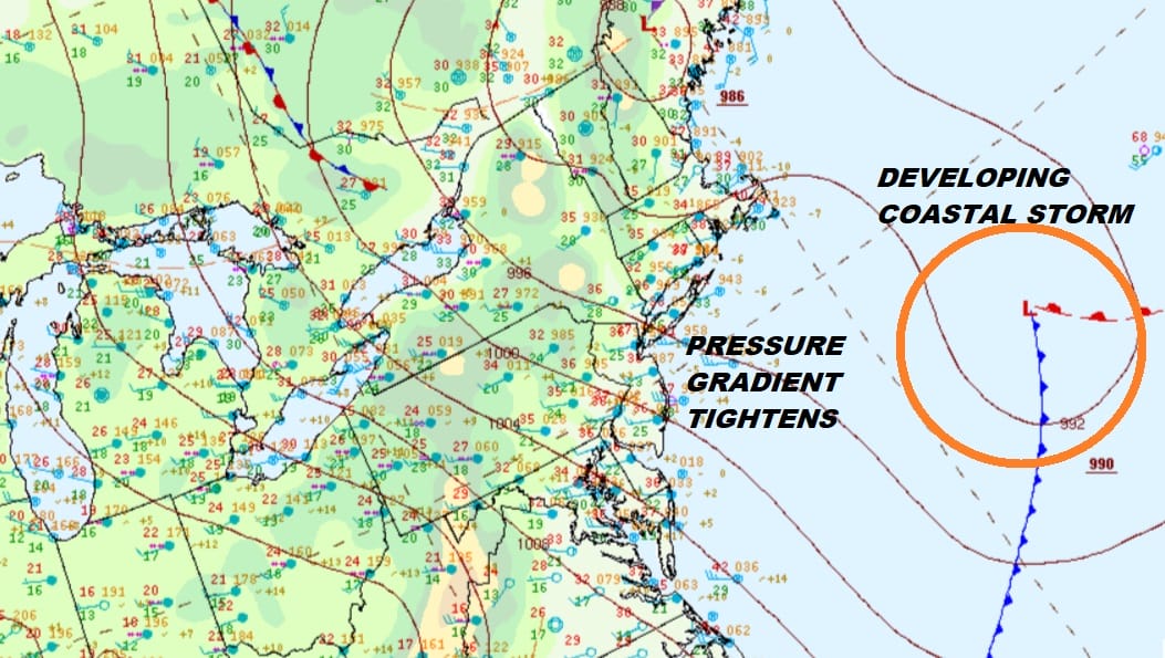
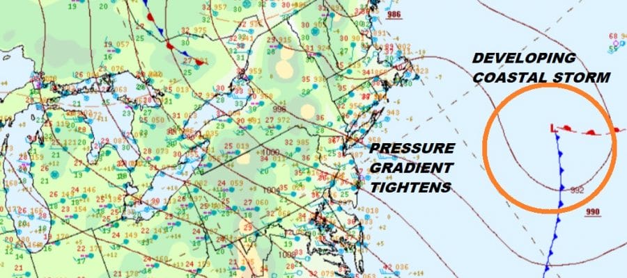
The winds will be cranking up today thanks the storm from Monday which is now beginning to weaken in Maine and a second low is redeveloping out in the ocean. That storm is going to explode into a major Atlantic Storm and bring gales rain and heavy to Eastern Maine, Nova Scotia and New Brunswick in Canada. This low is forecast to drop to pressures under 960 mb which is the equivalent of a strong category 2 hurricane. The pressure gradient here is going to tighten up and the result will be wind gusts of 40 mph or more at times.
EASTERN SATELLITE

The satellite loop shows us in a lot of clouds and there are some bands of snow showers trying to move southeastward down the Hudson Valley. Don’t rule out a few flurries or a snow shower today in this cold unstable flow and part of a strong upper trough moving through.Temperatures this morning are mostly in the mid to upper 30s and we probably won’t see those temperatures go anywhere today. Highs will probably sit in a range between 40 & 45 but add the wind and it will feel like it is in the upper 20s and lower 30s.
REGIONAL RADAR

There are some snow showers on the regional and local radars this morning They are actually moving from north to south which is a bit unusual. This is because there is a strong upper air storm to our north and we are on the west side of this system. It is creating a strong northerly flow aloft. This is also creating big lake effect snows south of Lake Ontario which is impacting cities like Syracuse & Rochester in upstate NY. Some of those snow showers have made down into Northern Pennsylvania and even a few in the Hudson Valley and Western Connecticut.
LOCAL RADAR NEW YORK CITY

Wind will continue to be an issue into Thursday so look for some partial clearing of skies tonight with most lows again in the 30s with some 20s inland if it were to completely clear out. The wind is likely to keep temperatures in a rather tight range. Sunshine is forecast for Thursday with a gusty wind though the winds will ease somewhat as the day goes on.
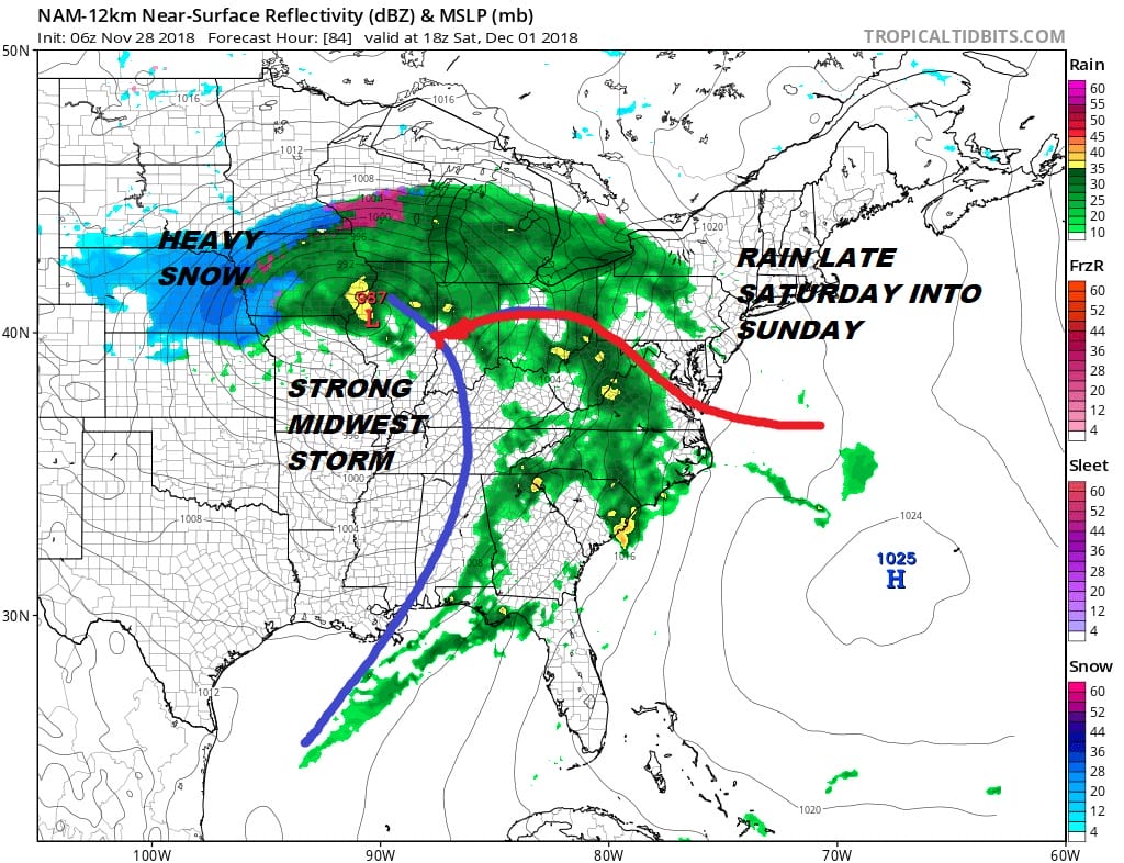
Friday will see some clouds move in as moisture with a weak trough runs out ahead of a developing storm heading for the Midwest Saturday. I’m not expecting much from this other than a passing brief rain or snow shower with highs in the 40s. This storm is another one that goes to our west with probably some kind of secondary low that develops just to our southeast Saturday night or early Sunday morning. Timing suggests rain arriving later in the day Saturday. It looks to rain Saturday night into Sunday morning with leftover clouds in the afternoon. Temperatures Saturday will be in the 40s to near 50. Sunday we could be in the 50s before colder air makes a return next week.
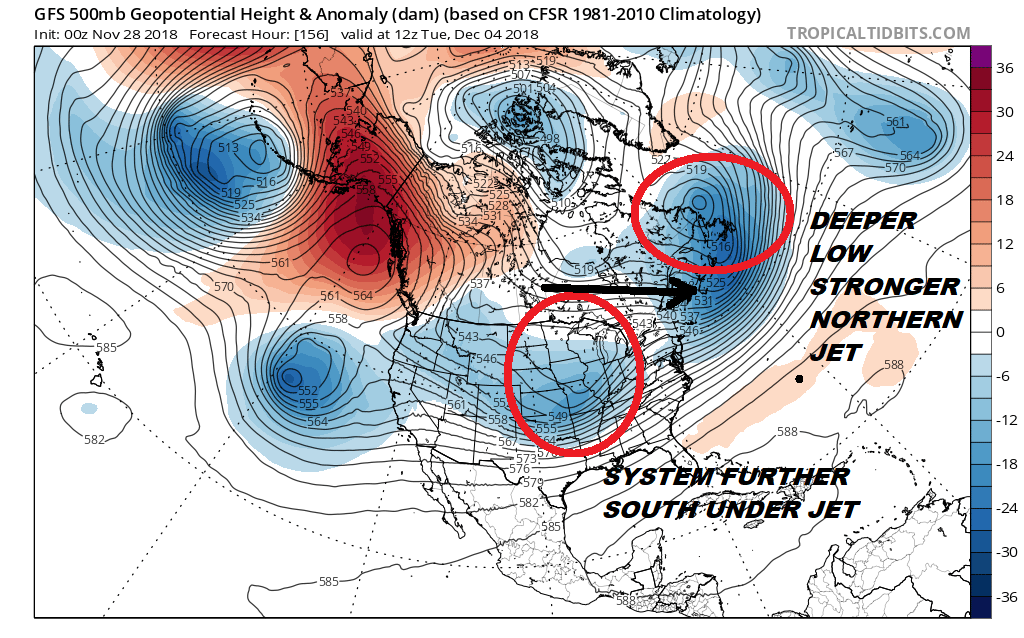
Interesting developments for next week regarding the potential for a second system for next Tuesday. Rather than take this system to the Great Lakes again models overnight show the northern part of the jet stream strengthening and actually suppressing this system much further to the south and east. It is a colder solution for next week and it is one which we should keep an eye on. Too much of a northern jet and you wind up with a system squashed so far south that it is of little consequence. This is what the European and Canadian models suggest while the GFS model has a more robust look to it with a low just to our south and east and some snow here for next Tuesday. We would like to see how models trend for the rest of the week with this and we have lots of time to watch this all evolve.
SUBSCRIBE TO PATREON FOR A WEATHER EXPERIENCE FREE OF ADS, EXCLUSIVE VIDEOS FOR MEMBERS ONLY AND MUCH MORE…STARTS AT $2 A MONTH..MESSAGE ME AT ANY TIME

MANY THANKS TO TROPICAL TIDBITS FOR THE USE OF MAPS
Please note that with regards to any tropical storms or hurricanes, should a storm be threatening, please consult your local National Weather Service office or your local government officials about what action you should be taking to protect life and property.

