DOWNLOAD MY NEW FREE JOESTRADAMUS WEATHER APP FOR ANDROID

STORM THREATS AHEAD RAIN LATER SATURDAY INTO EAR;Y SUNDAY MORNING
COLDER AIR FOLLOWS, NEXT SYSTEM TUESDAY BUT MAJOR MODEL DIFFERENCES
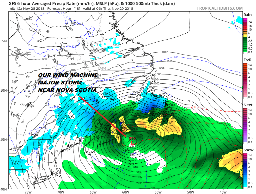
We continue to be under the influence of a huge storm that is developing well offshore. That storm will deepen to almost 950 mb which is about as intense as a category 3 hurricane! The low is moving toward Nova Scotia and the Canadian Maritime Provinces will be pounded with heavy rain snow and wind this afternoon into Thursday morning. Meanwhile the wind machine here continues with frequent gusts to 40 mph. It is a two hands on the steering wheel kind of day.
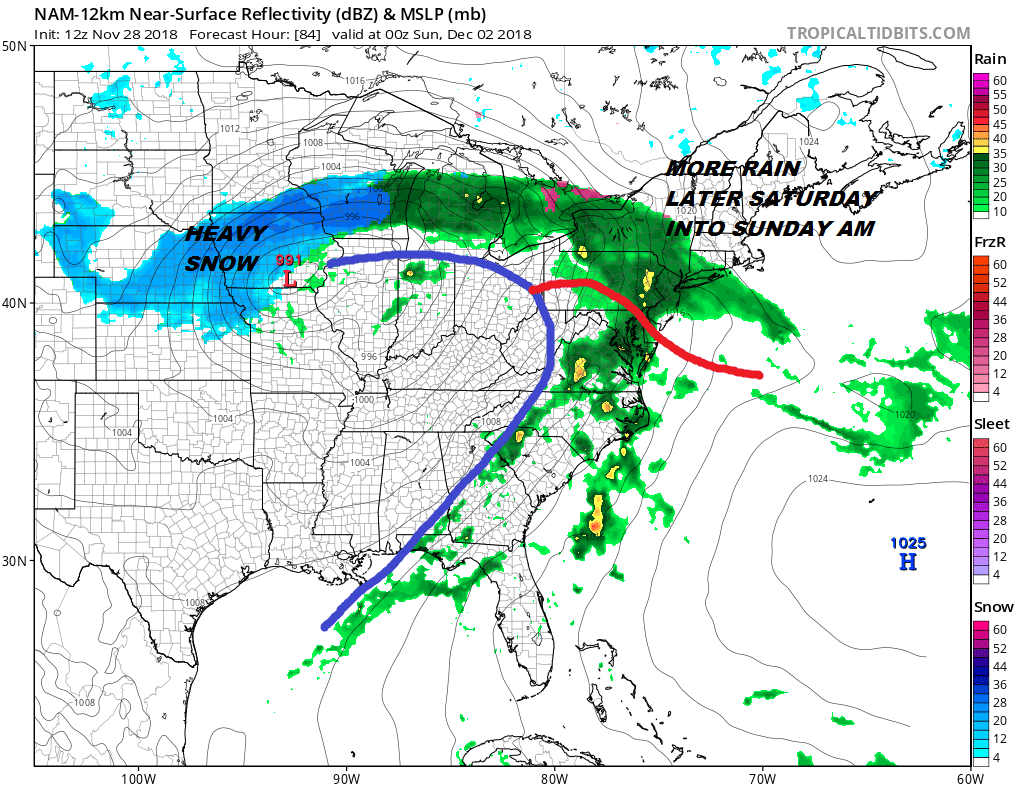
Moving forward we will have to wait for this system to get out of the way so as long as this is around there will be no serious weather issues into early Saturday morning. A weak weather system approaches from the Plains for later Friday into Friday night but other than clouds, this system basically falls apart. We move on the Saturday where a strong storm coming out of the Southwest US heads for the midwest. This is going bring more rain here later Saturday but it should be out by Sunday morning.
Once the warm front goes by we actually could get warm here on Sunday and 60 is not impossible if that warm front manages to struggle through. We should see improving weather conditions on Sunday so that should be the better of the two weekend days assuming that the warm front does get through. After this is done it is on to Tuesday and here is where the models diverge greatly.
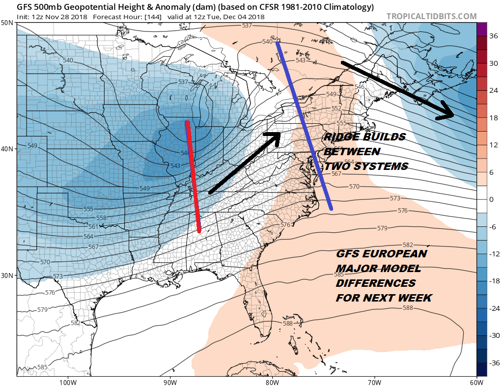
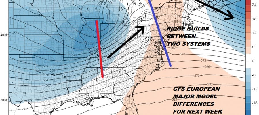
After two runs of the GFS overnight where the upper air was flatter and further south the GFS today has gone back to what it had yesterday where it pops up a ridge between the weekend system and the one for Tuesday. This would suggest another primary low running to the west with a secondary low developing near the coast. Since colder air comes in Monday (though how much is in question) it would signal a snow at the start to rain for the coast and snow inland that could go to rain as warmer air comes in from the ocean. The European on the other hand has a completely different idea for the upper air in the Eastern US.

Where the GFS has a ridge between the two systems the European has a strong northerly jet with a northwest flow of cold air that completely overwhelms the southern part of the jet stream and forces all the energy to the east and well offshore with nothing of consequence. The Canadian model is a compromise between the two and brings a low up the coast with snow inland and snow or rain coast and (just for laughs) we have the icon model which has the primary low going to the Western Great Lakes and an all rain affair here.
So how do we resolve this? At the moment we don’t. There are just too many short wave troughs running around and obviously the models are having trouble getting a handle on all of this. Each model is emphasizing a different aspect of this entire setup. I would throw the Icon out as too far west and too much ridging in the East. You could settle for a compromise between the two and go with the Canadian model. The GFS ensembles would support this.
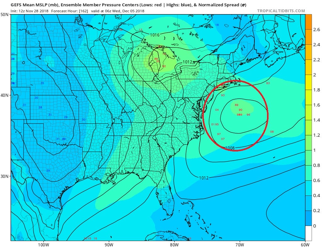
Since we are days from figuring out how this is going to go, we suggest we sit back and watch this play out. When this system arrives on the West Coast it is a powerhouse of energy so i suspect that is causing model volatility at the moment. Carry on for a couple of more days so we can get a handle on how the upper pattern winds up developing in the Eastern US.
SUBSCRIBE TO PATREON FOR A WEATHER EXPERIENCE FREE OF ADS, EXCLUSIVE VIDEOS FOR MEMBERS ONLY AND MUCH MORE…STARTS AT $2 A MONTH..MESSAGE ME AT ANY TIME

MANY THANKS TO TROPICAL TIDBITS FOR THE USE OF MAPS
Please note that with regards to any tropical storms or hurricanes, should a storm be threatening, please consult your local National Weather Service office or your local government officials about what action you should be taking to protect life and property.