Weekend Raw Rainy Saturday Slow Improvement Sunday Chilly Next Week
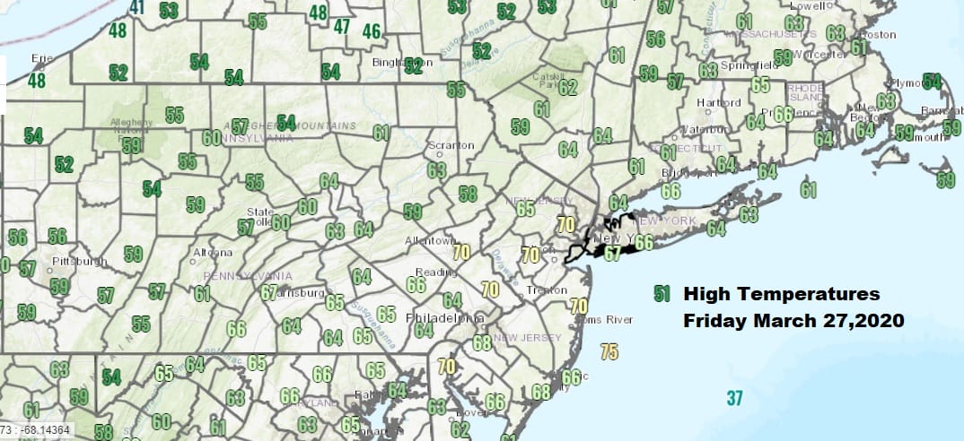
We finished off the week in spectacular fashion though we did start the day off with some rain but that ended shortly after day break. Sunshine broke out quite rapidly and that set the thermometers shooting higher and well above what as forecast yesterday. Highs reached the 60s to near 70 and even coastal areas managed their way into the 60s without much action from the sea breeze until late in the day. However to the south on the satellite picture we are seeing clouds and this is start of a developing warm front that will start coming back northward. Not tonight though as skies will start clear with clouds holding off until later tonight as they start to fill in from the south.
SATELLITE

REGIONAL RADAR

Regional radar is quiet across the Northeast as are the local radars however we are seeing rain across Northern Virginia moving east southeast. This is near the frontal boundary that passed through earlier today and is now stalled out to the south. Local radars are quiet and should remain so though by morning they will be busier. Temperatures tonight will settle in the 30s well inland and north of NYC but everywhere else will be in the 40s and from Philadelphia south and west it will be in the mid to upper 40s.
LOCAL RADAR NEW YORK CITY

LOCAL RADAR PHILADELPHIA


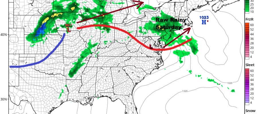
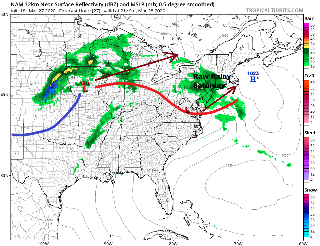
Of the two weekend days Saturday looks to be the worst of the two. It will be a raw day with rain. The high offshore keeps us in a cool easterly flow and the warm front will struggle northward. A wave will develop on the warm front and that will slow the northward progress. South of that front it will be in the 70s from Southern Virginia southward but in the 40s to at best near 50 everywhere else.
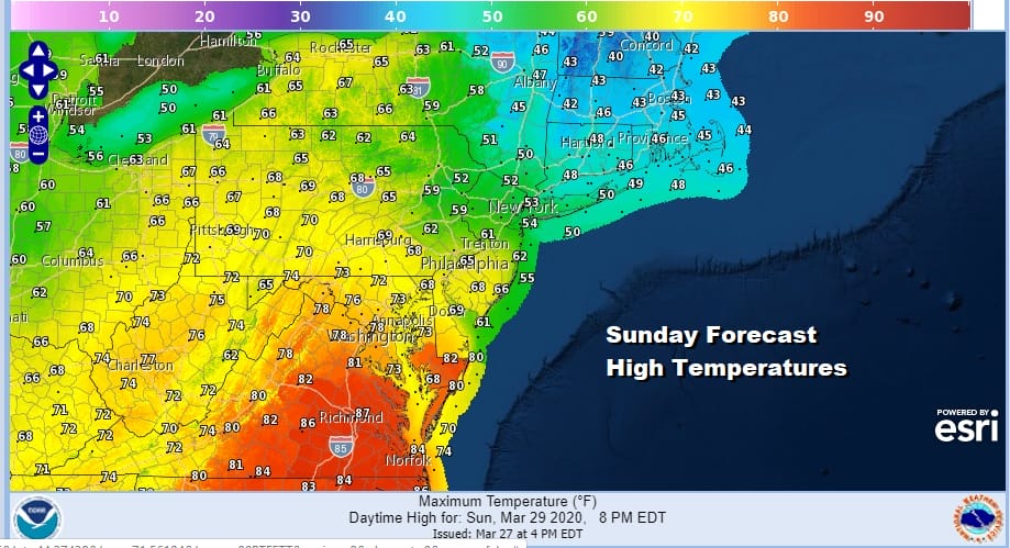
Sunday is going to be a real struggle with that warm front having a very difficult time moving northward. Anyone north of the warm front will likely stay in the 40s to near 50 with cloudy skies and some leftover rain drizzle and fog. South of the front will be a different story.
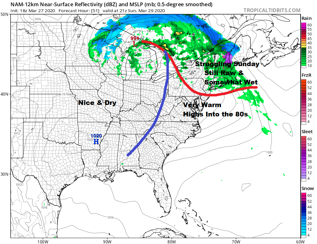
Areas south of the warm front will get into the 60s and if there is enough sun that breaks through the clouds it could go a little higher. Head down into Virginia and points south and we are looking at temperatures reaching the 70s and even a few 80 degree readings are likely!
The blocky pattern that is setting up across the Northern Atlantic is going to be playing games with us all next week. Sunday’s low will be forced eastward and that means Monday improvement will be slow with variable clouds around. There might even be a few scattered showers with an upper trough going by. Coastal areas might see a bit more sun and head into the lower 60s but it will be in the cooler 50s inland.

While there could be a dry day for Tuesday we are going to be setting up for the next low coming out of the Southern Plains and heading east to the MIddle Atlantic coast for Wednesday of next week. Rain will be moving in Tuesday night into Wednesday but there are questions as to how far north the rain area gets. We will resolve that issue over the weekend. Tuesday’s highs will be in the upper 40s to mid 50s with clouds increasing later in the day. Wednesday will be a day where much of the area once again will be dealing with a chilly northeast wind and highs just in the 40s. Once that low moves out we could have some decent dry weather Thursday through Saturday.
BE SURE TO DOWNLOAD THE FREE METEOROLOGIST JOE CIOFFI WEATHER APP &
ANGRY BEN’S FREE WEATHER APP “THE ANGRY WEATHERMAN!
MANY THANKS TO TROPICAL TIDBITS FOR THE USE OF MAPS
Please note that with regards to any severe weather, tropical storms, or hurricanes, should a storm be threatening, please consult your local National Weather Service office or your local government officials about what action you should be taking to protect life and property.


