Weekend Forecast Mostly Dry
Weekend Forecast Mostly Dry
Yesterday’s rain was fairly substantial for most of the area with rainfall amounts generally in the three quarters of an inch to an inch and half in some places. We are on the backside of this weather system now and we should see slow improvement today though clouds are going to be an issue at least for awhile. Gradually there will be enough dry air to produce some sunshine today. Temperatures will be struggling however as highs will only be in the low to mid 50s.


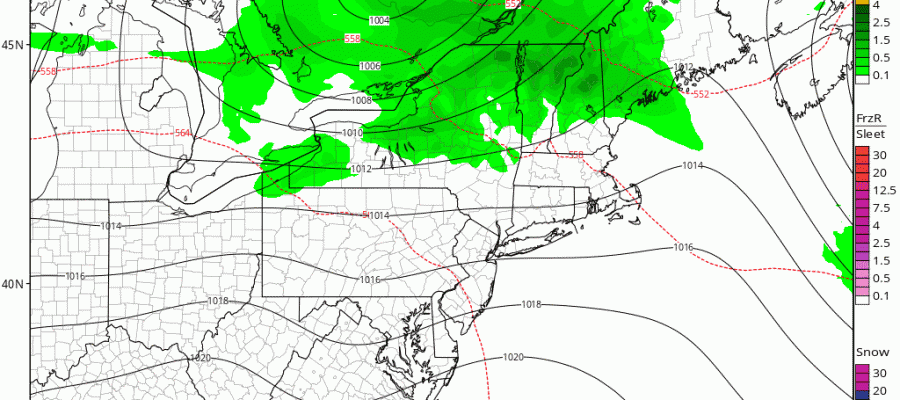
Regional radar shows rain and some snow up in Northern New Englang this morning but there are no weather radar issues for us right into early Sunday. Tonight skies should clear with lows in the 40s as the air behind yesterday’s storm makes a quick pull out. Saturday should be nice with sunshine and highs in the 60s.
GFS MODEL WEEKEND FORECAST
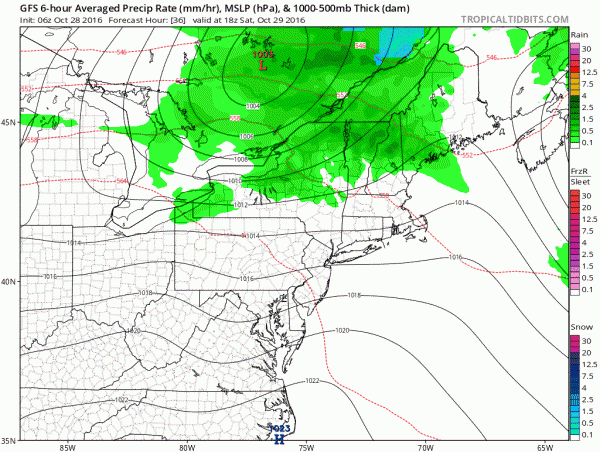
The weekend looks relatively uneventful. Models are having a tough time with the next cold front and the timing of when it passes Sunday morning. Sunday’s highs will be in the 60s to near 70 in some places. Then a weak wave follows on the front later Sunday afternoon and evening with a few showers. Much of next week looks quiet as we continue to watch how the weather pattern evolves over the coming weeks.
MANY THANKS TO TROPICAL TIDBITS FOR THE WONDERFUL USE OF THE MAPS
SNOW REMOVAL COMPANIES FOR YOUR WINTER NEEDS
LONG ISLAND ROCKLAND COUNTY Connecticut

![]()

WINTER WEATHER OUTLOOK VIDEOS
In case you missed them I’ve been previewing the upcoming winter in a series of posts and videos. Here are the first 2. More will be coming along. Links to the latest posts are below.
NEW JERSEY
LONG ISLAND AND NEARBY
WINTER 2016-2017 PART 3 NEW JERSEY
WINTER 2016-2017 PART 1 OCEAN WATER TEMPERATURES
WINTER 2016-2017 PART 2 ARCTIC SEA ICE AND SIBERIAN SNOW COVER
FiOS1 News Weather Forecast For Long Island
FiOS1 News Weather Forecast For New Jersey
FiOS1 News Weather Forecast For Hudson Valley
NATIONAL WEATHER SERVICE SNOW FORECASTS
LATEST JOESTRADAMUS ON THE LONG RANGE

Weather App

Don’t be without Meteorologist Joe Cioffi’s weather app. It is really a meteorologist app because you get my forecasts and my analysis and not some automated computer generated forecast based on the GFS model. This is why your app forecast changes every 6 hours. It is model driven with no human input at all. It gives you an icon, a temperature and no insight whatsoever.
It is a complete weather app to suit your forecast needs. All the weather information you need is right on your phone. Android or I-phone, use it to keep track of all the latest weather information and forecasts. This weather app is also free of advertising so you don’t have to worry about security issues with your device. An accurate forecast and no worries that your device is being compromised.
Use it in conjunction with my website and my facebook and twitter and you have complete weather coverage of all the latest weather and the long range outlook. The website has been redone and upgraded. Its easy to use and everything is archived so you can see how well Joe does or doesn’t do when it comes to forecasts and outlooks.
Just click on the google play button or the apple store button on the sidebar for my app which is on My Weather Concierge. Download the app for free. Subscribe to my forecasts on an ad free environment for just 99 cents a month.
Get my forecasts in the palm of your hand for less than the cost of a cup of Joe!


