Weekend Brings Risks for Showers Thunderstorms But It Doesn’t Rain All the Time

Weekend Brings Risks for Showers Thunderstorms But It Doesn’t Rain All the Time

This time of year it usually doesn’t rain all day long. Instead downpours and thunderstorms come in waves and vary from place to place. Some areas could be surrounded by showers and thunderstorms and not see a thing. The GFS model loop above illustrates this as an upper low lifting northeast out of the Ohio Valley triggers off some showers and thunderstorms but there will be dry periods in between such activity.
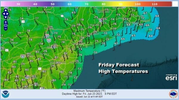
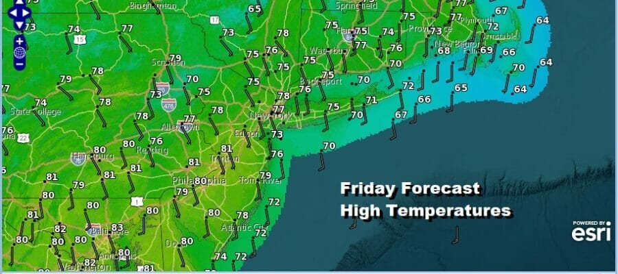
Timing this activity almost becomes a fools errand and it means being very radar dependent throughout the day and night. In between all this there will be lots of clouds along with a few breaks of self destruct sunshine. One important change today will be the wind direction which will be more from the south. This will bring up dew points into the 60s and highs will be in the 70s to some places around 80. Muggy conditions will develop today especially when some showers do occur which could be anywhere at anytime.
SATELLITE

WEATHER RADAR

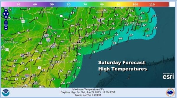
This is generally the forecast approach for the weekend. Look for some showers around tonight with lows in the 60s to around 70. Saturday and Sunday both will be humid days with clouds, some breaks of sun, and the risk for downpours and thunderstorms, though again it will vary from place to place and from time to time. Highs both Saturday and Sunday will reach into the 80s inland and in the 70s along the coast. Humidity levels will continue to be on the high side.

Weather systems will start to move along from west to east next week and that brings a slow moving cold front Monday. This will also produce showers and thunderstoms in the afternoon and evening and there is the possibilty for some severe weather in parts of the Eastern US. There still may be some showers and thunderstorms around Tuesday as the next upper trough moves through. Highs both Monday and Tuesday will be in the 80s with humidity levels on the high side. We should see drier conditions for the second half of next week.
BE SURE TO DOWNLOAD THE FREE METEOROLOGIST JOE CIOFFI WEATHER APP &
ANGRY BEN’S FREE WEATHER APP “THE ANGRY WEATHERMAN!
MANY THANKS TO TROPICAL TIDBITS FOR THE USE OF MAPS
Please note that with regards to any severe weather, tropical storms, or hurricanes, should a storm be threatening, please consult your local National Weather Service office or your local government officials about what action you should be taking to protect life and property.
(Amazon is an affilate of Meteorologist Joe Cioffi & earns commissions on sales.)


