Warm Muggy Conditions Scattered Downpours Thunderstorms
Severe Weather Risk Monday

Warm Muggy Conditions Scattered Downpours Thunderstorms
Severe Weather Risk Monday

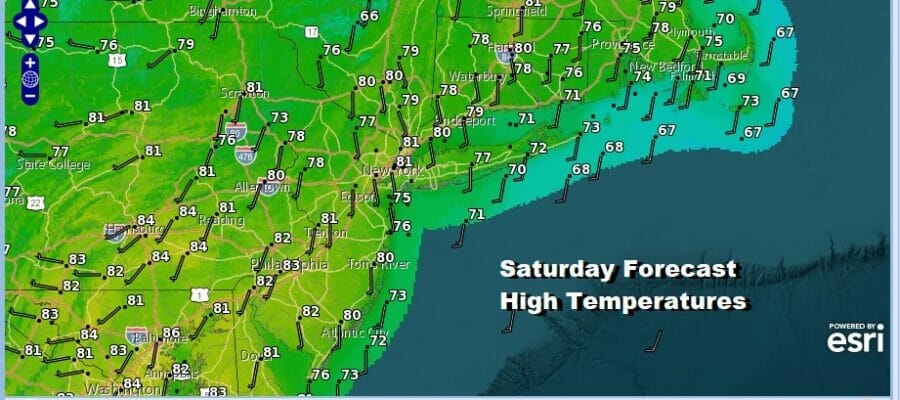
We continue to deal with a very stubborn upper trough that covers much of the Eastern US with variable conditions. They range from breaks of sunshine to downpours and thunderstorms. Through all of this we have seen muggy conditions develop as dew points have risen into the 60s. Temperatures this afternoon are topping out from the middle 70s near the coast to upper 70s and lower 80s inland.
SATELLITE

WEATHER RADAR

Many areas saw rain overnight and this morning and much of that is now north in Upstate NY and New England but the regional radar is peppered with scattered downpours and a few thunderstorms. The risk continues through Sunday but not everyone will see downpours, and those that do will see them come and go.

As far as temperatures are concerned, lows tonight will be in the 60s to around 70 degrees with high humidity. Sunday will be much like to day but highs wll reach the upper 70s near the coast and low to mid 80s inland. Again watch for the possibility of scattered downpours or thunderstorms.

The upper pattern is one where weather systems are slowly moving along. The problem in the Eastern US is that as one upper air system moves out, another one is right behind it to replace it. This basically prolongs the threat for showers and thunderstorms from day to day next week and it begins Monday with an approaching front. Ahead of it Monday it will be very warm and humid and there is the risk for severe weather especially inland Monday afternoon and evening.

The early outlook from the Storm Prediction Center is for a marginal risk of severe weather from Eastern Pennsylvania to Western New Jersey and points southward. I would not be surprised to eventually see some expansion of this area north and east with perhaps a slight risk area added.
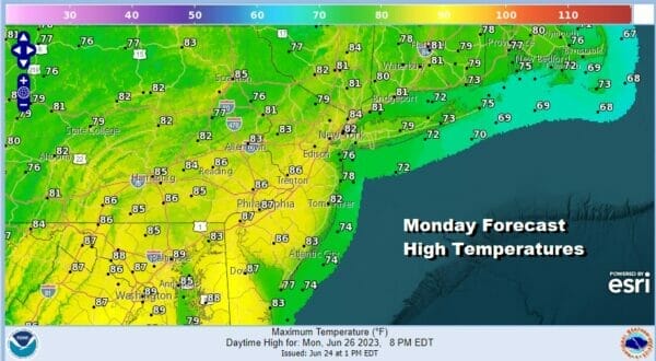
Ahead of any potential showers and thunderstorms Monday it will be very warm and humid with some sunshine in the mix and highs reaching the low to middle 80s except for 70s along the coast. Not much changes next week with trough after trough moving along so the risk for showers and thunderstorms will probably be in the forecast for every day next week. Again that doesn’t mean it rains all the time nor does it mean that it rains everywhere.
BE SURE TO DOWNLOAD THE FREE METEOROLOGIST JOE CIOFFI WEATHER APP &
ANGRY BEN’S FREE WEATHER APP “THE ANGRY WEATHERMAN!
MANY THANKS TO TROPICAL TIDBITS FOR THE USE OF MAPS
Please note that with regards to any severe weather, tropical storms, or hurricanes, should a storm be threatening, please consult your local National Weather Service office or your local government officials about what action you should be taking to protect life and property.
(Amazon is an affilate of Meteorologist Joe Cioffi & earns commissions on sales.)


