Severe Weather Risks Rise Monday Tuesday Northeast Mid Atlantic
As Cold Front Approaches

Severe Weather Risks Rise Monday Tuesday Northeast Mid Atlantic
As Cold Front Approaches

We continue to deal with a weakening upper trough over the Northeast today but it has weakened enough that we are seeing sunshine. The atmosphere is unstable and there will be some scattered showers and thunderstorms around this afternoon and evening. Again it will be a situation where some of you will see them, some of you won’t. In between the sun will take temperatures into the low and middle 80s coupled with high humidity. Muggy conditions prevail and they will continue Monday into Tuesday. A warm humid night lies ahead with most lows in the mid 60s to around 70 degrees.
SATELLITE

WEATHER RADAR

While all this is going on, a cold front is swinging through the Midwest and South today where we will see a regional outbreak of severe weather. Low pressure moving into the Eastern Great Lakes and a trailing cold front will push eastward Monday. The southerly flow ahead of it is bringing very warm humid air northward and this will likely set off showers and thunderstorms Monday afternoon and evening.

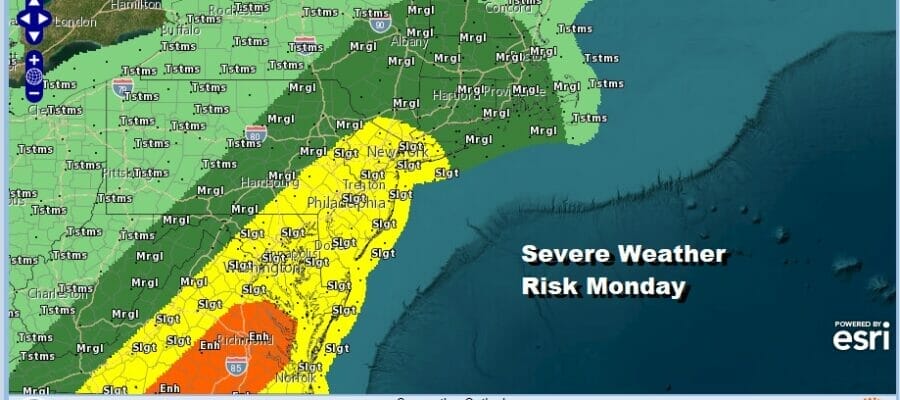
Monday will start with sunshine but as the front nears, we will see showers and thunderstorms develop. The dynamics are favorable for severe weather and the Storm Prediction Center shows a large area of slight risk for severe weather extending from the Hudson Valley and Long Island south through Virginia and into the Carolains. For now the enhanced risk remains south in Virginia and points southward.
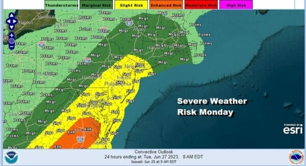
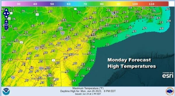
The models and the dynamics suggest that the risk will be more from strong winds rather than from tornadoes spinning up though the risk for tornadoes can’t be ruled out completely. Temperatures Monday will be in the 70s along the coast but will reach the 80s inland with high dew points making for a very uncomfortable day across the board.
The cold front will take its time moving east and the upper low and trough over the Great Lakes will be slow moving as well. This leads us to the risk there could be another round of showers and thunderstorms developing Tuesday and the Storm Prediction Center has introduced a large area of marginal risk up and down the immedita East Coast.
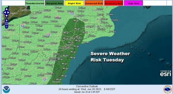
We likely will see this area expanded a bit as we draw closer to Tuesday. Otherwise it will be a day of clouds and sun with muggy conditions and highs reaching the upper 70s and lower 80s. This upper trough will likey sit along the coast for Wednesday and Thursday so we could still see some shower or thunderstorm risk for later this week.
BE SURE TO DOWNLOAD THE FREE METEOROLOGIST JOE CIOFFI WEATHER APP &
ANGRY BEN’S FREE WEATHER APP “THE ANGRY WEATHERMAN!
MANY THANKS TO TROPICAL TIDBITS FOR THE USE OF MAPS
Please note that with regards to any severe weather, tropical storms, or hurricanes, should a storm be threatening, please consult your local National Weather Service office or your local government officials about what action you should be taking to protect life and property.
(Amazon is an affilate of Meteorologist Joe Cioffi & earns commissions on sales.)


