Weekend And Thanksgiving Week Outlook
Eastern Pennsylvania to Southern New England

Weekend And Thanksgiving Week Outlook
Eastern Pennsylvania to Southern New England

We are finishing the week on a warm note but no rain is forecast for the daytime this Friday. Low pressure is forming off the Southeast US Coast and that low will track northeastward and well offshore. In the meantime we have a cold front that is coming in from the Great Lakes and Ohio Valley. This front will bring showers eastward but as it interacts with the low offshore, it will weaken and showers will arrive after midnight into Saturday morning. However they will be light and it is quite possible that some areas don’t see much of anything with the frontal passage.
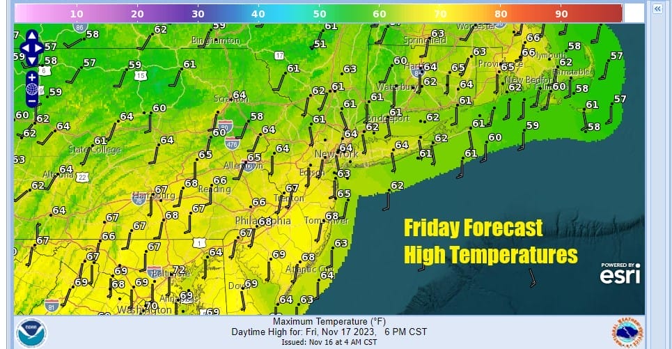
This leaves us today with sunshine giving way to arriving clouds. A south wind will probably hold the temperatures down somewhat as will the increase in cloud cover but either way most highs this afternoon will be in the middle to upper 60s. Radars are quiet for now showing no shower activity any where close.
SATELLITE WITH LIGHTNING STRIKES

WEATHER RADAR

Once any showers exit the coast weather conditions should slowly improve during the day Saturday. Leftover clouds in the morning should give way to some sunshine in the afternoon. Temperatures Saturday will reach their highs early in the day in the upper 50s to lower 60s but then they should begin to ease back in the 50s during Saturday afternoon.

Mostl lows Saturday night will be in the low to middle 30s with some 20s well inland under clear skies. Sunday should be a nice day of sunshine but it will be chilly with highs in the upper 40s and lower 50s. It will turn even colder Sunday night and Monday with Lows Sunday night in the mid 20s to lower 30s. Monday we will have sunshine but highs will just be in the low to mid 40s.

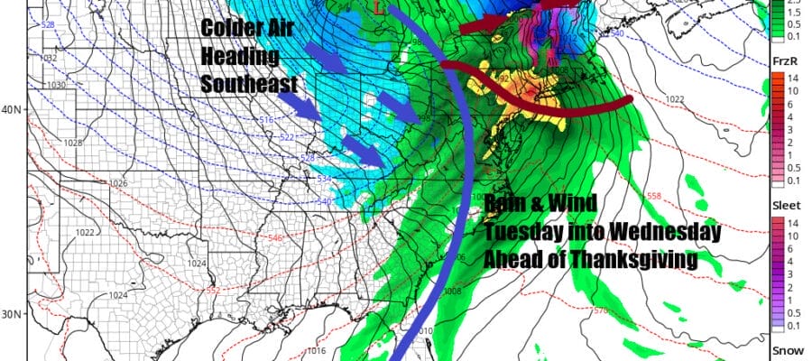
Weather conditions will deteriorate Tuesday as low pressure heads to the Great Lakes and Strengthens while a front swings eastward across the Ohio Valley and the Southern States. A secondary low will likel form on the front in the Appalachians and head northeast. This tightens the pressure gradient so look for southeast winds to increase Tuesday afternoon and night. Rain will develop later in the day and it will be heavy at times Tuesday night into Wednesday morning. This system could produce a couple of inches of rain so that plus the wind is likely to make travel rather difficult Tuesday into Wednesday. Rain should move out Wednesday morning leave us dry and colder with windy conditions Wednesday afternoon into Thanksgiving Day. As for temperatures, we will be in the 50s Tuesday then settle back into the 40s Wednesday. Right now Thanksgiving day looks to be partly sunny breezy and cold with highs just in the upper 30s and lower 40s.
BE SURE TO DOWNLOAD THE FREE METEOROLOGIST JOE CIOFFI WEATHER APP &
ANGRY BEN’S FREE WEATHER APP “THE ANGRY WEATHERMAN!
MANY THANKS TO TROPICAL TIDBITS FOR THE USE OF MAPS
Please note that with regards to any severe weather, tropical storms, or hurricanes, should a storm be threatening, please consult your local National Weather Service office or your local government officials about what action you should be taking to protect life and property.
(Amazon is an affilate of Meteorologist Joe Cioffi & earns commissions on sales.)