Remainder of the Weekend Dry & Chilly Rain Tuesday into Early Wednesday For Thanksgiving Travelers

Remainder of the Weekend Dry & Chilly Rain Tuesday into Early Wednesday For Thanksgiving Travelers

A cold front has passed through the Northeast and has now pushed offshore. It has also pushed off an intensifying storm off the coast southeast of Cape Cod. Dry chilly air is coming in on the backside of all this as well as clearing skies and afternoon sunshine. Gusty northwest winds will continue through the afternoon and evening and temperatures have already fallen off their highs from overnight. We will likely sit in the upper 40s and lower 50s for the rest of the day. Radar shows the bulk of the rain offshore and the rain that is over Eastern New England will be moving offshore shortly.
SATELLITE WITH LIGHTNING STRIKES

WEATHER RADAR

Cold air from Canada is moving southward thanks to high pressure over the Northern Great Lakes that is forecast to build into New England over the next couple of days. Skies will be mostly clear tonight and it will be on the cold side with lows by morning in the upper 20s to middle 30s. Sunday will be a sunny day with highs reaching 50 to 55 in most places.

The core of the cold air will be overhead Sunday night into Monday and that leaves us with clear skies Sunday night. Most lows will be in the mid to upper 20s inland and upper 20s lower 30s coast and the warmest urban locations. Monday dayside will be mostly sunny but cold with most highs in the low to middle 40s at best.

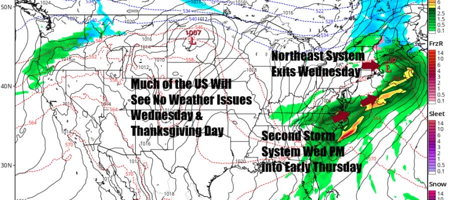
The situation weather wise has changed somewhat for Tuesday into Wednesday. It earlier seemed as if we would be having to deal with a stronger storm system that would have caused travel havoc over much of the Eastern US with heavy rain & wind. While we still have some rain and wind to deal with it will be less disruptive for travelers for Thanksgiving.

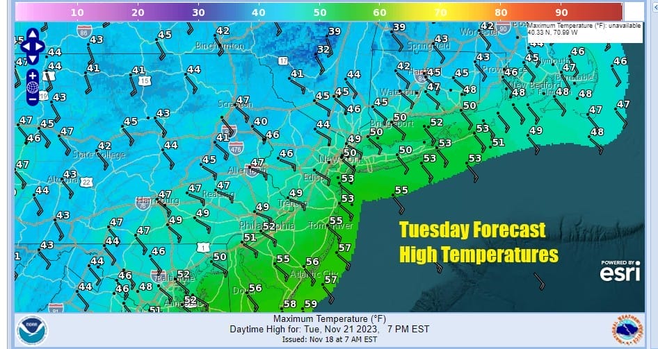
Low pressure heads from the Plains to the Great Lakes and we have a warm front cold front combination to deal with. This system will be somewhat loaded with moisture so a chilly rain develops during Tuesday and continues Tuesday night into Wednesday morning. Parts of the Catskills, the Middle and Upper Hudson Valley as well as Northeastern NY and Northern New England might see some snow or sleet from this at least at the onset. Most of the rain will be done by daybreak Wednesday. Tuesday Temperatures will be mostly in the upper 40s and lower 50s especially once rain gets underway.
This system could still produce 1 to 1.5 inches of rain for most of Eastern Pennsylvania to Southern New England. Winds from the southeast will pick up later Tuesday into Tuesday night and they could gust to 20 to 30 mph at times. Weather conditions will improve Wednesday with developing sunshine and breezy conditions with highs in the upper 40s and lower 50s. The front with Tuesday’s storm stalls across the Carolinas and another low will develop and strengthen as it moves offshore. We will need to watch and see whether the rain from this moves up the coast. Right now it seems the rain reaches as far north as Southern New Jersey and the southshore of Long Island briefly before pulling away to the east Thursday morning. Thanksgiving day will feature clouds and some sunshine, gusty northerly winds and temperatures that will be in the crisp low and middle 40s. Friday and next weekend look to be mostly dry though another cold front may approach late Sunday with some rain of showers but it is rather early in the game to speculate on this.
BE SURE TO DOWNLOAD THE FREE METEOROLOGIST JOE CIOFFI WEATHER APP &
ANGRY BEN’S FREE WEATHER APP “THE ANGRY WEATHERMAN!
MANY THANKS TO TROPICAL TIDBITS FOR THE USE OF MAPS
Please note that with regards to any severe weather, tropical storms, or hurricanes, should a storm be threatening, please consult your local National Weather Service office or your local government officials about what action you should be taking to protect life and property.
(Amazon is an affilate of Meteorologist Joe Cioffi & earns commissions on sales.)


