Rain Arrives Later Tuesday into Early Wednesday
Thanksgiving Day Breezy Cold & Dry

Rain Arrives Later Tuesday into Early Wednesday
Thanksgiving Day Breezy Cold & Dry

Thanksgiving week is a busy week for everyone especially when it comes to travel. The good news is that if you are travelling early (Sunday-Monday) you should have no issues. We have a nice weather day of sunshine across Eastern Pennsylvania to Southern New England with temperatures this afternoon topping out in the upper 40s in areas north of NYC and low to middle 50s just about everywhere else. Skies are sunny or no worse than partly sunny and radars show some light snow showers in upstate NY with an upper trough coming through but we do not expect issues this afternoon other than some patchy clouds that might come by later in the afternoon and evening.
SATELLITE WITH LIGHTNING STRIKES

WEATHER RADAR

Colder air is coming in tonight behind the trough and skies should become mostly clear. Most lows will be in the 20s inland and lower 30s along the coast. Monday will be a cold day for this time of year with sunshine thanks to high pressure building across Upstate NY and New England. Most high temperatures Monday afternoon will be in the low to middle 40s.

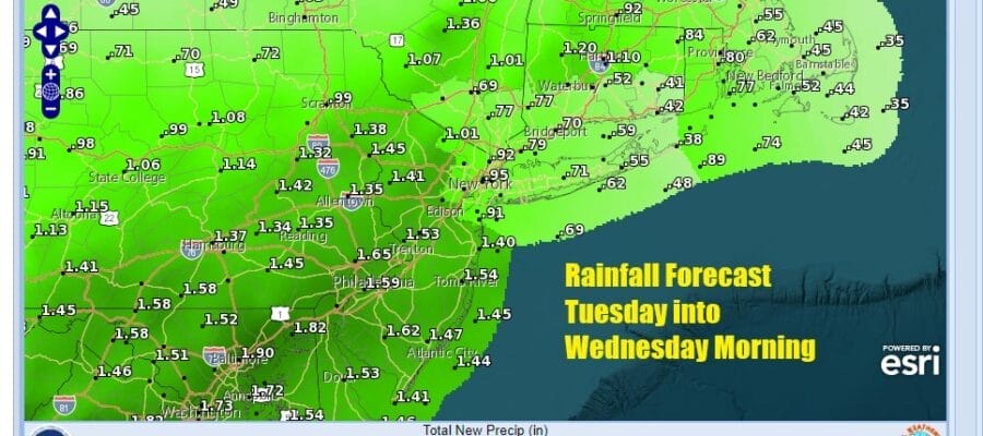
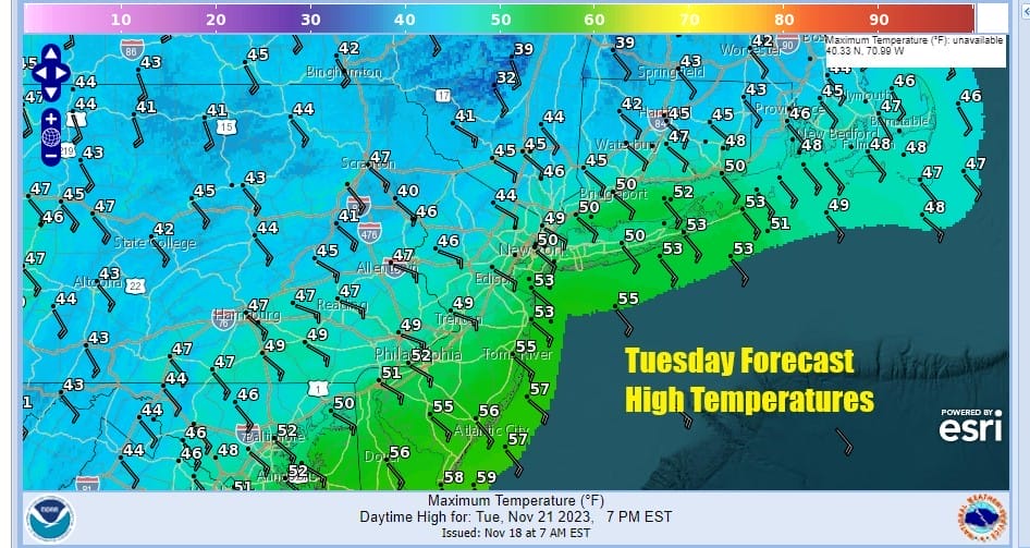
Low pressure will be moving out of the Southern Plains and into the Ohio Valley Tuesday, eventually winding up in the Great Lakes late Tuesday. A strong front is headed east and rain will develop from west to east Tuesday afternoon across Eastern Pennsylvania to Southern New England. Areas in Northern Pennsylvania northeastward to Upstate NY (Catskills north and northeast) will probably start out as some snow or sleet before going to rain. Temperatures Tuesday will be into the 50s but the highs will probably occur Tuesday evening and before midnight. Rain Tuesday night into early Wednesday morning will he heavy at times and most areas could see an inch to as much as an inch and a half of rainfall.
Wednesday the rain should be gone by daybreak leaving us with leftover clouds and some sunshine along with a developing gusty wind. Temperatures Wednesday will be in the 50s though the high temperatures will probably be reached early in the day. Winds will pick up furhter late in the afternoon into Wednesday night so if you are travelling by plane, there could be some delays due to gusty winds.

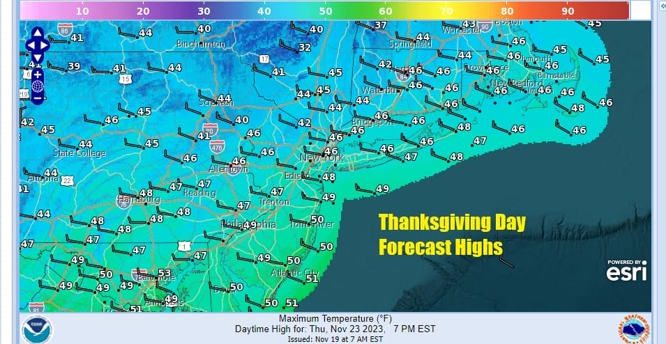
Low pressure developing offshore will strengthen Wedesday night and this is the main cause of the gust winds. Thursday morning will be breezy inland and windy along the coast as we start the day in the low to middle 30s. Thanksgiving dayside will be dry and breezy with some sunshine. Most highs will be in the low to middle 40s.
Friday looks also to be dry with some sunshine. Most highs will be in the 40s to around 50. Some questions are coming up for next weekend as low pressure may try and inch northward up the coast and sets up for a chilly rain chance later Saturday into Sunday but models lately have been very jumpy and this is purely speculative at this stage.
BE SURE TO DOWNLOAD THE FREE METEOROLOGIST JOE CIOFFI WEATHER APP &
ANGRY BEN’S FREE WEATHER APP “THE ANGRY WEATHERMAN!
MANY THANKS TO TROPICAL TIDBITS FOR THE USE OF MAPS
Please note that with regards to any severe weather, tropical storms, or hurricanes, should a storm be threatening, please consult your local National Weather Service office or your local government officials about what action you should be taking to protect life and property.
(Amazon is an affilate of Meteorologist Joe Cioffi & earns commissions on sales.)


