Long Island Thanksgiving Week Rain Late Tuesday into Early Wednesday,
Dry Windy Chilly Thanksgiving
 USE COUPON CODE IWANTAWEATHERSTATION GET 10 PERCENT OFF ANY PURCHASE

Long Island Thanksgiving Week Rain Late Tuesday into Early Wednesday,
Dry Windy Chilly Thanksgiving

Thanksgiving week begins on the cold side. We should be in the low 50s for highs but Monday low 40s will be the highs for the day. High pressure is building in Southeastern Canada and New England and northerly winds will filter down cold air. There will be sunshine all day long but it will be somewhat ineffective. Radars will be quiet and there are no precipitation issues to worry about at least into the first part of Tuesday. A clear cold night sets up for Monday night and Tuesday morning lows will be in the mid to upper 20s. Clouds will start to arrive during the overnight period.
SATELLITE

WEATHER RADAR


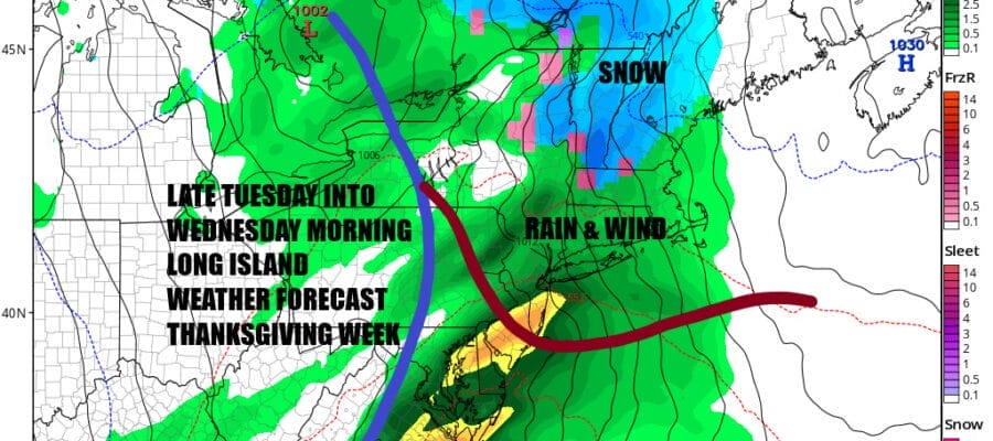
Tuesday we will see thickening clouds and an increasing wind from the east and southeast. Low pressure is headed for the Great Lakes pushing an area of rain eastward across Pennsylvania. Rain will develop mid to late afternoon and it will become heavy at times Tuesday night. Traveling late Tuesday and Tuesday night will be wet with 1 to 1.5 inches of rain likely. Gusty winds and rain will probably create air travel delays.

Temperatures Tuesday will likely struggle in the 40s but should be able to push up into the 50s during Tuesday night. The highs for Wednesday will come early in the day. The Great Lakes low will redevelop near the south shore of Long Island, moving east and strengthening. Winds will pick up Wednesday from the northwest and clouds will give way to some sunshine. Temperatures will likely ease into the 40s late in the day.

Thursday Thanksgiving Day will start out windy but winds should ease some as the day wears on. There will be sunshine and dry conditions for the holiday. Morning lows will be in the low to mid 30s and afternoon highs Thursday will be in the mid to upper 40s. Longer range Friday looks dry and then there is the chance for another round of rain at some point over the weekend though that is speculative at this point.
BE SURE TO DOWNLOAD THE FREE METEOROLOGIST JOE CIOFFI WEATHER APP &
ANGRY BEN’S FREE WEATHER APP “THE ANGRY WEATHERMAN!
MANY THANKS TO TROPICAL TIDBITS FOR THE USE OF MAPS
Please note that with regards to any severe weather, tropical storms, or hurricanes, should a storm be threatening, please consult your local National Weather Service office or your local government officials about what action you should be taking to protect life and property.