Week Ahead Outlook Chilly End to April
Watching System Late Week Into Next Weekend

Week Ahead Outlook Chilly End to April
Watching System Late Week Into Next Weekend
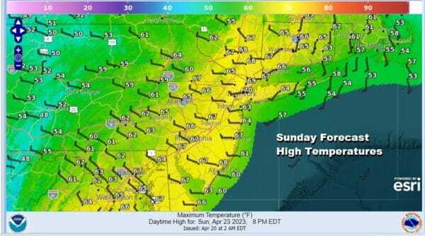
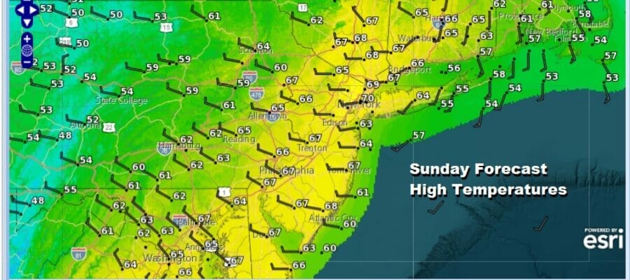
We have some work to do today as last night’ cold front with showers and thunderstorms is literally crawling eastward. We are seeing rain on the radar this morning but the rain should end from west to east this morning west of NYC while it will take longer for rain to end across Long Island and Southern New England. Sky condition improvement on this Sunday will be slow to occur with lots of leftover clouds around. Temperatures today will be mostly in the 60s.
SATELLITE

WEATHER RADAR

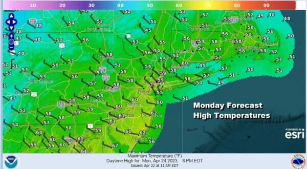
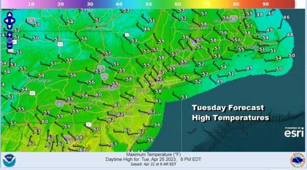
The week ahead will feature a cooler than normal weather pattern setting up with storm tracks to the south. Chilly Canadain air for this time of year will spread across much of the Eastern US. Tonight skies should partially clear with lows mostly in the 40s. Monday and Tuesday will be two cool days with an unstable atmosphere creating partly sunny conditions. Highs Monday and Tuesday will likely be just in the 50s to at best near 60 degrees in one or two warm spots.
The blocky nature of the pattern for this coming week will be taking storms and tracking them to our south rather than to our west. This will bring lots of rain from Gulf States to the Southeast US along with the chance for some severe weather along the way later this week.

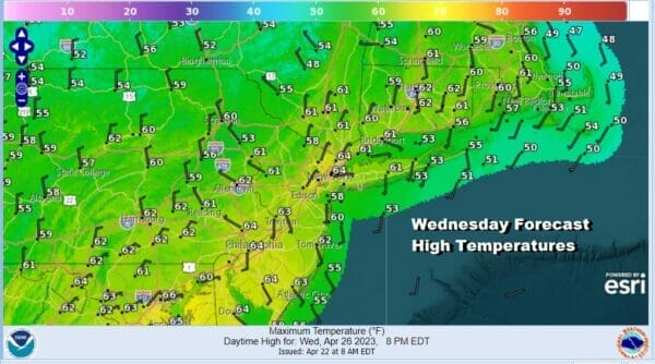
This leaves us with no issues for Wednesday which right now looks to be the best day of the week. Sunshine should be abundant with the atmosphere more stable and highs Wednesday will likely reach into the 60s in most places. Winds will be come more variable and that could lead to local sea breezes in areas where we have south and east facing shorelines.
Some rain could make it up the coast late Thursday or Friday as low pressure develops off the Southeast US coast and attempts to move northward. The northern part of the jet stream will be rather strong and could attempt to suppress this system to the south. We will have to see how this evolves over the next few days. For now we will call Thursday cloudy or increasing clouds with highs in the upper 50s to lower 60s and will throw in the chance for some rain Thursday night and Friday with highs again in the upper 50s to lower 60s, though that could be too high if we wind up with some sort of low offshore, rain and a northeast wind.
BE SURE TO DOWNLOAD THE FREE METEOROLOGIST JOE CIOFFI WEATHER APP &
ANGRY BEN’S FREE WEATHER APP “THE ANGRY WEATHERMAN!
MANY THANKS TO TROPICAL TIDBITS & F5 WEATHER FOR THE USE OF MAPS
Please note that with regards to any severe weather, tropical storms, or hurricanes, should a storm be threatening, please consult your local National Weather Service office or your local government officials about what action you should be taking to protect life and property.


