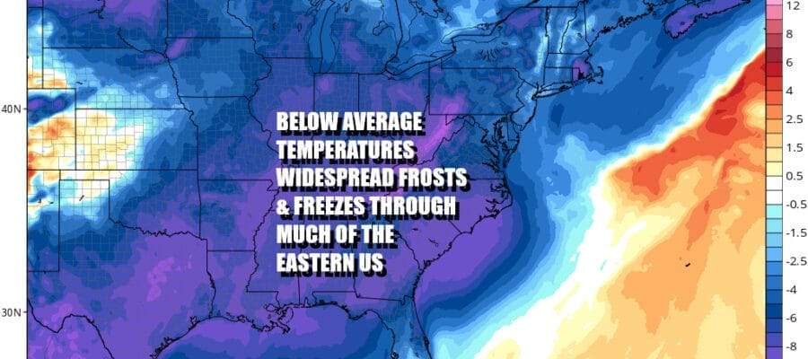
Week Ahead Much Colder Widespread Frosts Freezes
Tuesday Night Wednesday Night

Week Ahead Much Colder Widespread Frosts Freezes
Tuesday Night Wednesday Night
We have now put an end to the record high temperatures and we begin the stair step down to the coldest air of the Autumn season so far. Showers are on the radar today and we will see on and off showers though most of the showers will be to the north of Route 78 in Pennsylvania and New Jersey with less rain to the south. This will be the case both today and for Monday as another wave moves along a stalled cold front.

Radars are showing areas of showers moving southwest to northeast as the first wave runs up into New England today. The frontal passage and the position of the wave will lead to a rather wide range in temperatures today. Close to the boundary in Southern New Jersey and Southern Pennsylvania most highs will be in the 60s and a few warm spots could touch 70 while north of Route 80 in New Jersey northeastward into Southern New England, most highs will be in the upper 40s to mid 50s.

Satellite loops and radar loops show clouds and showers moving along from southwest to northeast. Heavier rains are moving through Upstate NY and Interior New England. We should see a break in the shower activity later today and tonight and then one more push of showers will move through Monday. That push doesn’t look especially robust.
SATELLITE

WEATHER RADAR

Tonight we will have cloudy skies with most lows in the 50s. Monday we will be another day of wide ranges in temperatures from 60s and 70s Southern Pennsylvania and Southern New Jersey southward, and 50s and 60s to the north. Once the final push moves through and the front can prgress offshore, colder air will start to come in.

Colder air will begin to spread eastward and southward. This is a widespeead shot of cold air that will bring frosts and freezes to a large portion of the Northeast, Mid Atlantic, Southeast, Deep South, Ohio Valley and Great Lakes. For the Northeast and Mid Atlantic states, Tuesday night into Wednesday morning and Wednesday night into Thursday morning will see the coldest temperatures with many areas down in the 20s.

We will have a cold day Tuesday with highs just in the 40s to around 50 area wide with lots of clouds around. Models are still showing low pressure well east of Florida moving northward and this may clip coastal areas of New Jersey and Long Island with a little rain late Tuesday into Tuesday night but it should not amount to much from what we are seeing. Otherwise we will see skies clear Tuesday night with lows in the 20s inland and middle 30s coast and warmer urban locations.


Wednesday we will see some sunshine and a few clouds but highs will just be in the 40s to around 50 or so and then down we go again Wednesday night into Thursday morning with lows in the 20s inland and low to mid 30s along coastal locations and in warmer urban areas.


Temperatures should start to bounce Thursday with highs back into the 50s in most areas. The core of the cold air will move out Thursday and this leaves us with a chilly night Thursday night into Friday morning but off the lows of the week. Friday looks nice and sunny with highs in the 50s.
SATELLITE WITH LIGHTNING STRIKES

WEATHER RADAR
BE SURE TO DOWNLOAD THE FREE METEOROLOGIST JOE CIOFFI WEATHER APP &
ANGRY BEN’S FREE WEATHER APP “THE ANGRY WEATHERMAN!
MANY THANKS TO TROPICAL TIDBITS FOR THE USE OF MAPS
Please note that with regards to any severe weather, tropical storms, or hurricanes, should a storm be threatening, please consult your local National Weather Service office or your local government officials about what action you should be taking to protect life and property.
(Amazon is an affilate of Meteorologist Joe Cioffi & earns commissions on sales.)


