Last Day of Record Highs Much Colder Pattern Takes Hold
First Frosts Freezes & Maybe Flakes

Last Day of Record Highs Much Colder Pattern Takes Hold
First Frosts Freezes & Maybe Flakes

It has been quite the warm weather pattern and today will be the third and last day of record highs as a cold front will begin the process of taking us back down to where we should be for this time of year and eventually we will see genuine late October cold. First off though we have today which will be the better of the two weekend days. Sunshine will take highs to the upper 70s and lower 80s. Winds will be northwest today which will add to the daytime heating. There are no issues on the radar as showers are definitely not an issue today nor tonight.
SATELLITE WITH LIGHTNING STRIKES

WEATHER RADAR

A cold front moves through late today and stalls out just offshore and to our south overnight. This will set the stage for a much different Sunday. The stalled front and a wave that will be developing on the front will cause clouds to increase overnight. Most overnight lows will be in the upper 40s to mid 50s.
Showery rains will develop Sunday morning and continue on and off into Sunday evening as the first wave goes by. The frontal boundary will lie across Southern Pennsylvania and Southern New Jersey so the further south you go the less rain you will see. Also we will see large temperature changes. The largest changes will be north of New York City, the Hudson Valley, Southern New England and Long Island where highs will only be in the upper 40s to lower 50s. A raw northeast wind and rain will keep temperatures in check.
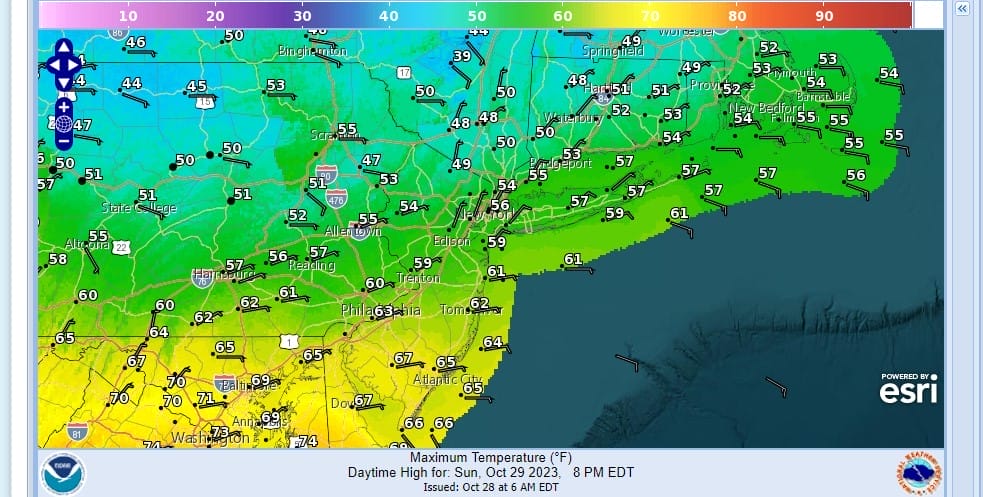
Closer to the frontal boundary in Southern Pennsylvania and Southern New Jersey highs will be in the lower 60s We are talking about 20 to 30 degree temperatures swings which is rather impressive. We will see a break from showers Sunday night but they will fire up again early Monday morning and continue until mid or late afternoon. Temperatures Monday will be like Sunday in a wide range from upper 40s and lower 50s north of NYC and low to mid 60s south and southeast of Philadelphia.

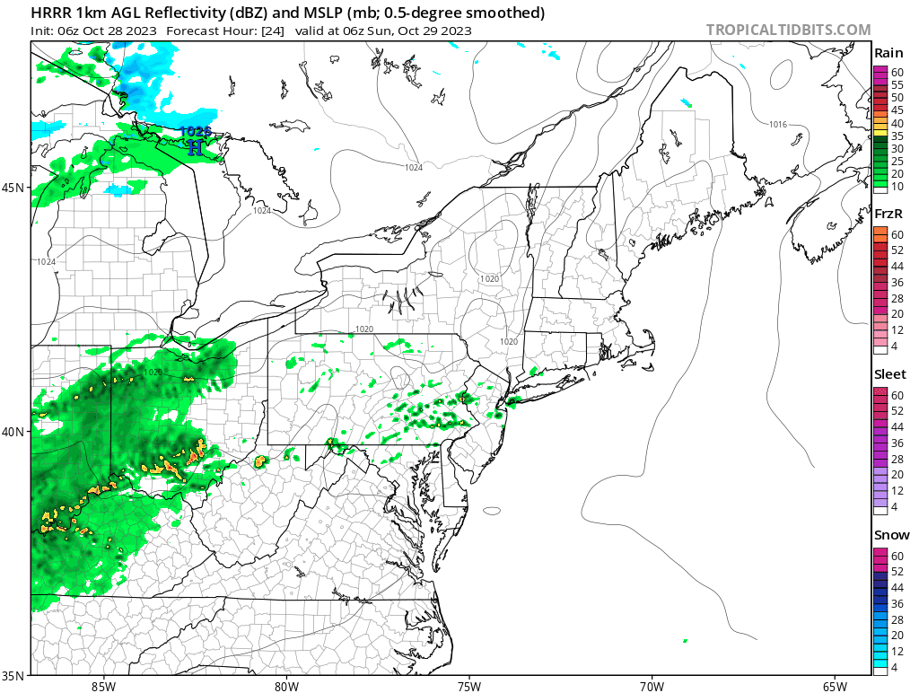
Even colder air comes in Tuesday with the frontal boundary just offshore and it seems that we will see a third wave develop just offshore. Though the GFS above has the wave suppressed the other models do not and this will lead us to a cloudy day Tuesday with most highs just in the 40s to around 50. Rain will develope from south to north late Tuesday and last into early Wednesday. Temperatures will drop into the 30s Tuesday night and it is possible that inland areas could see some sleet or wet snow mixing in. This wave should pull out Wednesday morning leaving us very cold with a gusty wind and highs just in the 40s.
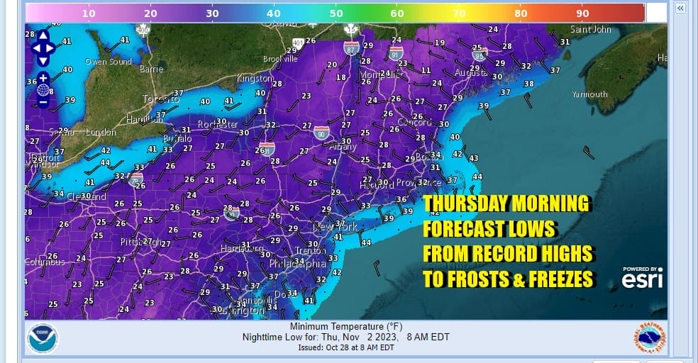
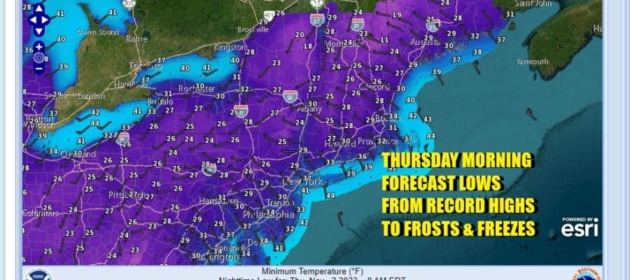
Areas inland will see freezes Wednesday morning but Frosts and freezes are likely over a wide area Wednesday night into Thursday morning as lows will be in the 20s in many inland areas and low to mid 30s along the coast. Wednesday and Thursday highs will be just in the 40s during the day. The cold air mass will pull out Friday and we should see higher temperatures next weekend.
BE SURE TO DOWNLOAD THE FREE METEOROLOGIST JOE CIOFFI WEATHER APP &
ANGRY BEN’S FREE WEATHER APP “THE ANGRY WEATHERMAN!
MANY THANKS TO TROPICAL TIDBITS FOR THE USE OF MAPS
Please note that with regards to any severe weather, tropical storms, or hurricanes, should a storm be threatening, please consult your local National Weather Service office or your local government officials about what action you should be taking to protect life and property.
(Amazon is an affilate of Meteorologist Joe Cioffi & earns commissions on sales.)


