
Week Ahead Mostly Dry Cautious On Memorial Day Weekend Outlook

Week Ahead Mostly Dry Cautious On Memorial Day Weekend Outlook
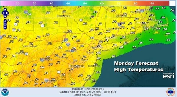
The work week begins on a good note as skies are clear across the Northeast and Mid Atlantic states and so are the radars. It will be a nice day of sunshine from start to finish. The satellite loop shows lower pressures offshore with clouds and rain but that low is racing away to the northeast and of no issue here. Highs this afternoon will be mostly in the low to mid 70s with temperatures a little cooler along south and east facing shorelines thanks to the sea breeze.
SATELLITE

WEATHER RADAR

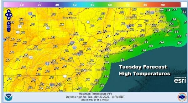
We are pretty much in cruise control into Wednesday so skies tonight should be mostly clear with most lows in the upper 40s to mid 50s. Tuesday will be a nice day with the high to the northeast. Yes the flow will be onshore and that will hold temperatures down somewhat. Highs will be in the mid to upper 60s along south and east facing shorelines while inland highs will be in a range of 70 to 75.
Wednesday sees a bit of a change as the high to the northeast loses its grip and we look northward to a cold front that will be dropping south from Eastern Canada and New England. Winds will bend more to the west especailly inland so highs Wednesday will reach the middle to upper 70s inland. The coast will still have some onshore flow impacts so highs will be lower there.
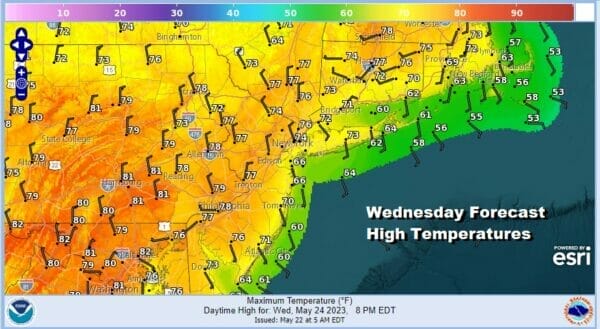
There will be a fair amount of sunshine for most of the day Wednesday. The front will produce some clouds and there is the outside chance for a shower, mainly over New England. Otherwise it passes through and drops southward as a very strong high pressure cell builds in from the Northern Great Lakes for Thursday and Friday.

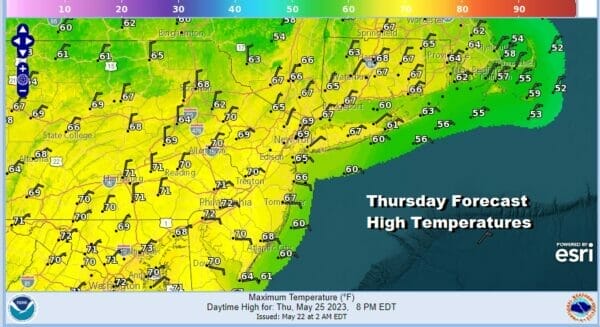
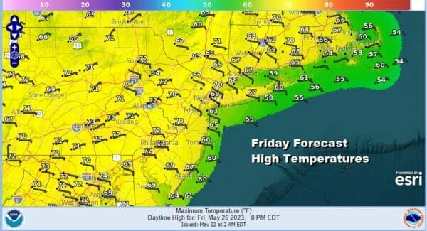
We can say that there are no issues for Thursday and Friday. High pressure will be in total control but notice that the onshore flow over the Middle and South Atlantic states creates low pressure off the Southeast coast late this week. With that low comes an area of rain over the Coastal Carolinas. While all that is going on, Eastern Pennsylvania to Southern New England will have sunshine Thursday and at least some sun for Friday. The winds will be from the northeast or east so temperatures will be held down somewhat. Highs both days will be in the upper 60s coast and low to mid 70s well inland.
The issue for the weekend will be whether the high to the north will be strong enough to suppress the developing low off the Southeast US coast which would normally try to move northward. The latest European run shows the idea that the low is suppressed to the south for the entire weekend. The Gfs model shows the low being suppressed to the south Saturday but then it moves northward with rain for Sunday and Monday.

Right now I am leaning to the idea that Saturday could be okay with some sunshine and clouds and a wind from the northeast so it will be on the cool side. Highs will be in the upper 60s along coastal areas and lower 70s inland. Beyond Saturday it becomes more of a question mark and the Memorial Day holiday weekend is usually a weekend where we lose 1 and sometimes 2 days to clouds and some rain. I think there is a fair chance we could see the high to the north win out and suppress the coastal system to the south and east but we need to see models come in a bit more in the coming days. As for temperatures this weekend, with the winds off the ocean, highs will likely be on the cool side for this time of year, mid and upper 60s coast and low to middle 70s inland, assuming that we don’t see any rain.
BE SURE TO DOWNLOAD THE FREE METEOROLOGIST JOE CIOFFI WEATHER APP &
ANGRY BEN’S FREE WEATHER APP “THE ANGRY WEATHERMAN!
MANY THANKS TO TROPICAL TIDBITS FOR THE USE OF MAPS
Please note that with regards to any severe weather, tropical storms, or hurricanes, should a storm be threatening, please consult your local National Weather Service office or your local government officials about what action you should be taking to protect life and property.
(Amazon is an affilate of Meteorologist Joe Cioffi & earns commissions on sales.)


